Search results for tag #space
![[?]](https://files.defcon.social/dcsocial-s3/accounts/avatars/113/208/344/507/078/943/original/014820ad22daee1c.jpg)
Star Trails Over Indonesia
*Image Credit & Licence: HuiChieh (my dark sky)
Explanation:
Both land and sky were restless. The unsettled land included erupting Mount Semeru in the distance, the caldera of steaming Mount Bromo on the left, flowing fog, and the lights of moving cars along roads that thread between hills and volcanoes in Bromo Tengger Semeru National Park in East Java, Indonesia. The stirring sky included stars circling the South Celestial Pole and a meteor streaking across the image right. The above 270-image composite was taken from King Kong Hill in mid-June over two hours, with a rising Moon lighting the landscape.
https://apod.nasa.gov/apod/ap140818.html
#space #earth #astrophotography #photography #astroart #art #science #nature

Explanation:
Both land and sky were restless. The unsettled land included erupting Mount Semeru in the distance, the caldera of steaming Mount Bromo on the left, flowing fog, and the lights of moving cars along roads that thread between hills and volcanoes in Bromo Tengger Semeru National Park in East Java, Indonesia. The stirring sky included stars circling the South Celestial Pole and a meteor streaking across the image right. The above 270-image composite was taken from King Kong Hill in mid-June over two hours, with a rising Moon lighting the landscape.
Authors & editors: Robert Nemiroff (MTU) & Jerry Bonnell (UMCP)
NASA Official: Phillip Newman Specific rights apply.
NASA Web Privacy Policy and Important Notices
A service of: ASD at NASA / GSFC
& Michigan Tech. U.")
Alt...
2014 August 18
Star Trails Over Indonesia
*Image Credit & Licence: HuiChieh (my dark sky)
Explanation:
Both land and sky were restless. The unsettled land included erupting Mount Semeru in the distance, the caldera of steaming Mount Bromo on the left, flowing fog, and the lights of moving cars along roads that thread between hills and volcanoes in Bromo Tengger Semeru National Park in East Java, Indonesia. The stirring sky included stars circling the South Celestial Pole and a meteor streaking across the image right. The above 270-image composite was taken from King Kong Hill in mid-June over two hours, with a rising Moon lighting the landscape.
Authors & editors: Robert Nemiroff (MTU) & Jerry Bonnell (UMCP)
NASA Official: Phillip Newman Specific rights apply.
NASA Web Privacy Policy and Important Notices
A service of: ASD at NASA / GSFC
& Michigan Tech. U.
A Luminous Night
* Image Credit & Copyright: Phil Hart
Explanation:
What shines in the world at night? Just visible to the eye, a rare electric blue glow spread along the shores of Victoria Lake on January 16, 2013. Against reflections of a light near the horizon, this digitally stacked long exposure recorded the bioluminescence of Noctiluca scintillans, plankton stimulated by the lapping waves. Above, the night skies of the Gippsland Lakes region, Victoria, Australia shine with a fainter greenish airglow. Oxygen atoms in the upper atmosphere, initially excited by ultraviolet sunlight, produce the more widely seen fading atmospheric chemiluminescence. Washed out by the Earth's rotation, the faint band of the southern summer Milky Way stretches from the horizon as star trails circle the South Celestial Pole.
https://apod.nasa.gov/apod/ap140809.html
#space #earth #astrophotography #photography #astroart #art #science #education
 & Jerry Bonnell (UMCP)
NASA Official: Phillip Newman Specific rights apply.
NASA Web Privacy Policy and Important Notices
A service of: ASD at NASA / GSFC
& Michigan Tech. U.")
Alt...
2014 August 9
A Luminous Night
* Image Credit & Copyright: Phil Hart
Explanation:
What shines in the world at night? Just visible to the eye, a rare electric blue glow spread along the shores of Victoria Lake on January 16, 2013. Against reflections of a light near the horizon, this digitally stacked long exposure recorded the bioluminescence of Noctiluca scintillans, plankton stimulated by the lapping waves. Above, the night skies of the Gippsland Lakes region, Victoria, Australia shine with a fainter greenish airglow. Oxygen atoms in the upper atmosphere, initially excited by ultraviolet sunlight, produce the more widely seen fading atmospheric chemiluminescence. Washed out by the Earth's rotation, the faint band of the southern summer Milky Way stretches from the horizon as star trails circle the South Celestial Pole.
Authors & editors: Robert Nemiroff (MTU) & Jerry Bonnell (UMCP)
NASA Official: Phillip Newman Specific rights apply.
NASA Web Privacy Policy and Important Notices
A service of: ASD at NASA / GSFC
& Michigan Tech. U.
Rio at Night
* Image Credit & Copyright: Babak Tafreshi (TWAN)
Explanation:
In this night skyscape setting stars trail above the western horizon over Rio de Janeiro, Brazil, a venue for the 2014 World Cup. Gentle arcs from the bright, colorful stars of Orion are near the center of the frame, while the starfield itself straddles planet Earth's celestial equator during the long exposure. Of course, trails from more local lights seem to create the strident paths through the scene. Air traffic smears an intense glow over an airport at the far right, while helicopters fly above the city and boats cruise near the coast. Striping the waterfront are tantalizing reflections of bright lights along Rio's central beaches, Botafogo and Flamengo. Near the horizon, the brightest fixed light is the famous Cristo statue overlooking Rio at night.
https://apod.nasa.gov/apod/ap140620.html
#space #earth #astrophotography #photography #astroart #art #science #nature

Explanation:
In this night skyscape setting stars trail above the western horizon over Rio de Janeiro, Brazil, a venue for the 2014 World Cup. Gentle arcs from the bright, colorful stars of Orion are near the center of the frame, while the starfield itself straddles planet Earth's celestial equator during the long exposure. Of course, trails from more local lights seem to create the strident paths through the scene. Air traffic smears an intense glow over an airport at the far right, while helicopters fly above the city and boats cruise near the coast. Striping the waterfront are tantalizing reflections of bright lights along Rio's central beaches, Botafogo and Flamengo. Near the horizon, the brightest fixed light is the famous Cristo statue overlooking Rio at night.
Authors & editors: Robert Nemiroff (MTU) & Jerry Bonnell (UMCP)
NASA Official: Phillip Newman Specific rights apply.
NASA Web Privacy Policy and Important Notices
A service of: ASD at NASA / GSFC
& Michigan Tech. U.")
Alt...
2014 June 20
Rio at Night
* Image Credit & Copyright: Babak Tafreshi (TWAN)
Explanation:
In this night skyscape setting stars trail above the western horizon over Rio de Janeiro, Brazil, a venue for the 2014 World Cup. Gentle arcs from the bright, colorful stars of Orion are near the center of the frame, while the starfield itself straddles planet Earth's celestial equator during the long exposure. Of course, trails from more local lights seem to create the strident paths through the scene. Air traffic smears an intense glow over an airport at the far right, while helicopters fly above the city and boats cruise near the coast. Striping the waterfront are tantalizing reflections of bright lights along Rio's central beaches, Botafogo and Flamengo. Near the horizon, the brightest fixed light is the famous Cristo statue overlooking Rio at night.
Authors & editors: Robert Nemiroff (MTU) & Jerry Bonnell (UMCP)
NASA Official: Phillip Newman Specific rights apply.
NASA Web Privacy Policy and Important Notices
A service of: ASD at NASA / GSFC
& Michigan Tech. U.
Star Trails over El Capitan
* Image Credit & Copyright: Michael Bolte (UCSC)
Explanation:
Towering 3,000 feet from base to summit, the famous granite face of El Capitan in Earth's Yosemite National Park just hides the planet's north celestial pole in this skyscape. Of course, the north celestial pole is at the center of all the star trails. Their short arcs reflecting the planet's daily rotation on its axis are traced in a digital stack of 36 sequential exposures. Linear trails of passing airplane navigation lights and a flare from car lights along the road below are also captured in the sequential stack. But the punctuated trail of light seen against the sheer El Capitan itself follows a climbing team on the night of November 8, 2013. The team is ascending toward the summit along The Nose, a historic rock climbing route.
https://apod.nasa.gov/apod/ap140321.html
#space #earth #astrophotography #photography #astroart #art #science #nature

Explanation:
Towering 3,000 feet from base to summit, the famous granite face of El Capitan in Earth's Yosemite National Park just hides the planet's north celestial pole in this skyscape. Of course, the north celestial pole is at the center of all the star trails. Their short arcs reflecting the planet's daily rotation on its axis are traced in a digital stack of 36 sequential exposures. Linear trails of passing airplane navigation lights and a flare from car lights along the road below are also captured in the sequential stack. But the punctuated trail of light seen against the sheer El Capitan itself follows a climbing team on the night of November 8, 2013. The team is ascending toward the summit along The Nose, a historic rock climbing route.
Authors & editors: Robert Nemiroff (MTU) & Jerry Bonnell (UMCP)
NASA Official: Phillip Newman Specific rights apply.
NASA Web Privacy Policy and Important Notices
A service of: ASD at NASA / GSFC
& Michigan Tech. U.")
Alt...
2014 March 21
Star Trails over El Capitan
* Image Credit & Copyright: Michael Bolte (UCSC)
Explanation:
Towering 3,000 feet from base to summit, the famous granite face of El Capitan in Earth's Yosemite National Park just hides the planet's north celestial pole in this skyscape. Of course, the north celestial pole is at the center of all the star trails. Their short arcs reflecting the planet's daily rotation on its axis are traced in a digital stack of 36 sequential exposures. Linear trails of passing airplane navigation lights and a flare from car lights along the road below are also captured in the sequential stack. But the punctuated trail of light seen against the sheer El Capitan itself follows a climbing team on the night of November 8, 2013. The team is ascending toward the summit along The Nose, a historic rock climbing route.
Authors & editors: Robert Nemiroff (MTU) & Jerry Bonnell (UMCP)
NASA Official: Phillip Newman Specific rights apply.
NASA Web Privacy Policy and Important Notices
A service of: ASD at NASA / GSFC
& Michigan Tech. U.
Warped Sky: Star Trails over Arches National Park
* Image Credit & Copyright: Vincent Brady
Explanation:
What's happened to the sky? A time warp, of sorts, and a digital space warp too. The time warp occurs because this image captured in a single frame a two and a half hour exposure of the night sky. As a result, prominent star trails are visible. The space warp occurs because the picture is actually a full 360 degree panorama, horizontally compressed to fit your browser. As the Earth rotated, stars appeared to circle both the North Celestial Pole, on the left, and the South Celestial Pole, just below the horizon on the right. The above panorama over Arches National Park in Utah, USA, was captured two weeks ago during early morning hours. While the eye-catching texture of ancient layered sandstone covers the image foreground, twenty-meter tall Delicate Arch is visible on the far right, and the distant arch of our Milky Way Galaxy is visible near the image center.
https://apod.nasa.gov/apod/ap140317.html
#space #earth #astrophotography #photography #astroart #art #science #nature
 & Jerry Bonnell (UMCP)
NASA Official: Phillip Newman Specific rights apply.
NASA Web Privacy Policy and Important Notices
A service of: ASD at NASA / GSFC
& Michigan Tech. U.")
Alt...
2014 March 17
Warped Sky: Star Trails over Arches National Park
* Image Credit & Copyright: Vincent Brady
Explanation:
What's happened to the sky? A time warp, of sorts, and a digital space warp too. The time warp occurs because this image captured in a single frame a two and a half hour exposure of the night sky. As a result, prominent star trails are visible. The space warp occurs because the picture is actually a full 360 degree panorama, horizontally compressed to fit your browser. As the Earth rotated, stars appeared to circle both the North Celestial Pole, on the left, and the South Celestial Pole, just below the horizon on the right. The above panorama over Arches National Park in Utah, USA, was captured two weeks ago during early morning hours. While the eye-catching texture of ancient layered sandstone covers the image foreground, twenty-meter tall Delicate Arch is visible on the far right, and the distant arch of our Milky Way Galaxy is visible near the image center.
Authors & editors: Robert Nemiroff (MTU) & Jerry Bonnell (UMCP)
NASA Official: Phillip Newman Specific rights apply.
NASA Web Privacy Policy and Important Notices
A service of: ASD at NASA / GSFC
& Michigan Tech. U.
Rocket Streak and Star Trails
* Image Credit & Copyright: Mike Killian / AmericaSpace
Explanation:
Fixed to a tripod and looking east across the Kennedy Space Center's Turn Basin, a camera captured these star trails as a series of short exposures over a three hour period on the evening of January 23rd. Positioned just a few miles from Space Launch Complex 41 at Cape Canaveral Air Force Station, it also captured a spectacular night launch of an Atlas V rocket carrying NASA's Tracking and Data Relay Satellite TDRS-L. Creating the trails, the apparent motion of the stars through the sky is just a reflection of the daily rotation of planet Earth on its axis. But that rotation is also the reason the rocket streak follows a path arcing east across the Atlantic. Launching toward the east, in the direction of Earth's rotation, adds the rotation velocity to the rocket and reduces the fuel needed to reach orbit. A little ironically, TDRS-L is destined for a geostationary orbit. From there, 36,000 kilometers or so above the equator, its orbital period will match Earth's rotation and the satellite will hang motionless in planet Earth's sky.
https://apod.nasa.gov/apod/ap140130.html
#space #earth #astrophotography #photography #astroart #science #nature
 & Jerry Bonnell (UMCP)
NASA Official: Phillip Newman Specific rights apply.
NASA Web Privacy Policy and Important Notices
A service of: ASD at NASA / GSFC
& Michigan Tech. U.")
Alt...
2014 January 30
Rocket Streak and Star Trails
* Image Credit & Copyright: Mike Killian / AmericaSpace
Explanation:
Fixed to a tripod and looking east across the Kennedy Space Center's Turn Basin, a camera captured these star trails as a series of short exposures over a three hour period on the evening of January 23rd. Positioned just a few miles from Space Launch Complex 41 at Cape Canaveral Air Force Station, it also captured a spectacular night launch of an Atlas V rocket carrying NASA's Tracking and Data Relay Satellite TDRS-L. Creating the trails, the apparent motion of the stars through the sky is just a reflection of the daily rotation of planet Earth on its axis. But that rotation is also the reason the rocket streak follows a path arcing east across the Atlantic. Launching toward the east, in the direction of Earth's rotation, adds the rotation velocity to the rocket and reduces the fuel needed to reach orbit. A little ironically, TDRS-L is destined for a geostationary orbit. From there, 36,000 kilometers or so above the equator, its orbital period will match Earth's rotation and the satellite will hang motionless in planet Earth's sky.
Authors & editors: Robert Nemiroff (MTU) & Jerry Bonnell (UMCP)
NASA Official: Phillip Newman Specific rights apply.
NASA Web Privacy Policy and Important Notices
A service of: ASD at NASA / GSFC
& Michigan Tech. U.
Grand Canyon Star Trails
* Image Credit & Copyright: Babak Tafreshi (TWAN)
Explanation:
One of the natural wonders of planet Earth, the Grand Canyon in the American southwest stretches across this early evening skyscape. The digitally stacked sequence reveals the canyon's layers of sedimentary rock in bright moonlight. Exposed sedimentary rock layers range in age from about 200 million to 2 billion years old, a window to history on a geological timescale. A recent study has found evidence that the canyon itself may have been carved by erosion as much as 70 million years ago. With the camera fixed to a tripod while Earth rotates, each star above carves a graceful arc through the night sky. The concentric arcs are centered on the north celestial pole, the extension of Earth's rotation axis into space, presently near the bright star Polaris.
https://apod.nasa.gov/apod/ap130303.html
#space #earth #astrophotography #photography #astroart #art #science #nature

Explanation:
One of the natural wonders of planet Earth, the Grand Canyon in the American southwest stretches across this early evening skyscape. The digitally stacked sequence reveals the canyon's layers of sedimentary rock in bright moonlight. Exposed sedimentary rock layers range in age from about 200 million to 2 billion years old, a window to history on a geological timescale. A recent study has found evidence that the canyon itself may have been carved by erosion as much as 70 million years ago. With the camera fixed to a tripod while Earth rotates, each star above carves a graceful arc through the night sky. The concentric arcs are centered on the north celestial pole, the extension of Earth's rotation axis into space, presently near the bright star Polaris.
Authors & editors: Robert Nemiroff (MTU) & Jerry Bonnell (UMCP)
NASA Official: Phillip Newman Specific rights apply.
NASA Web Privacy Policy and Important Notices
A service of: ASD at NASA / GSFC
& Michigan Tech. U.")
Alt...
2013 March 3
Grand Canyon Star Trails
* Image Credit & Copyright: Babak Tafreshi (TWAN)
Explanation:
One of the natural wonders of planet Earth, the Grand Canyon in the American southwest stretches across this early evening skyscape. The digitally stacked sequence reveals the canyon's layers of sedimentary rock in bright moonlight. Exposed sedimentary rock layers range in age from about 200 million to 2 billion years old, a window to history on a geological timescale. A recent study has found evidence that the canyon itself may have been carved by erosion as much as 70 million years ago. With the camera fixed to a tripod while Earth rotates, each star above carves a graceful arc through the night sky. The concentric arcs are centered on the north celestial pole, the extension of Earth's rotation axis into space, presently near the bright star Polaris.
Authors & editors: Robert Nemiroff (MTU) & Jerry Bonnell (UMCP)
NASA Official: Phillip Newman Specific rights apply.
NASA Web Privacy Policy and Important Notices
A service of: ASD at NASA / GSFC
& Michigan Tech. U.
Teimareh Petroglyphs and Star Trails
* Image Credit & Copyright: Babak Tafreshi (TWAN)
Explanation:
Engraved in rock, these ancient petroglyphs are abundant in the Teimareh valley, located in the Zagros Mountains of central Iran. They likely tell a tale of hunters and animals found in the middle eastern valley 6,000 years ago or more, etched by artists in a prehistoric age. In the night sky above are star trails etched by the rotation of planet Earth during the long composite exposure made with a modern digital camera. On the left, the center of the star trail arcs is the North Celestial Pole (NCP), the extension of Earth's axis into space. Polaris, the North Star, leaves the bright, short, stubby trail closest to the NCP. But when these petroglyphs were carved, Polaris would have made a long arc through the night. Since the Earth's rotation axis precesses like a wobbling top, 6,000 years ago the NCP was near the border of the constellations Draco and Ursa Major, some 30 degrees from its current location in planet Earth's sky.
https://apod.nasa.gov/apod/ap120712.html
#space #earth #astrophotography #photography #astroart #art #science #nature

Explanation:
Engraved in rock, these ancient petroglyphs are abundant in the Teimareh valley, located in the Zagros Mountains of central Iran. They likely tell a tale of hunters and animals found in the middle eastern valley 6,000 years ago or more, etched by artists in a prehistoric age. In the night sky above are star trails etched by the rotation of planet Earth during the long composite exposure made with a modern digital camera. On the left, the center of the star trail arcs is the North Celestial Pole (NCP), the extension of Earth's axis into space. Polaris, the North Star, leaves the bright, short, stubby trail closest to the NCP. But when these petroglyphs were carved, Polaris would have made a long arc through the night. Since the Earth's rotation axis precesses like a wobbling top, 6,000 years ago the NCP was near the border of the constellations Draco and Ursa Major, some 30 degrees from its current location in planet Earth's sky.
Authors & editors: Robert Nemiroff (MTU) & Jerry Bonnell (UMCP)
NASA Official: Phillip Newman Specific rights apply.
NASA Web Privacy Policy and Important Notices
A service of: ASD at NASA / GSFC
& Michigan Tech. U.")
Alt...
2012 July 12
Teimareh Petroglyphs and Star Trails
* Image Credit & Copyright: Babak Tafreshi (TWAN)
Explanation:
Engraved in rock, these ancient petroglyphs are abundant in the Teimareh valley, located in the Zagros Mountains of central Iran. They likely tell a tale of hunters and animals found in the middle eastern valley 6,000 years ago or more, etched by artists in a prehistoric age. In the night sky above are star trails etched by the rotation of planet Earth during the long composite exposure made with a modern digital camera. On the left, the center of the star trail arcs is the North Celestial Pole (NCP), the extension of Earth's axis into space. Polaris, the North Star, leaves the bright, short, stubby trail closest to the NCP. But when these petroglyphs were carved, Polaris would have made a long arc through the night. Since the Earth's rotation axis precesses like a wobbling top, 6,000 years ago the NCP was near the border of the constellations Draco and Ursa Major, some 30 degrees from its current location in planet Earth's sky.
Authors & editors: Robert Nemiroff (MTU) & Jerry Bonnell (UMCP)
NASA Official: Phillip Newman Specific rights apply.
NASA Web Privacy Policy and Important Notices
A service of: ASD at NASA / GSFC
& Michigan Tech. U.
La Silla Star Trails North and South
* Image Credit & Copyright: Alexandre Santerne (Laboratoire d'Astrophysique de Marseille / Observatoire de Haute Provence)
Explanation:
If the tripod is set up at ESO's La Silla Observatory, high in the Atacama desert of Chile, your star trails would look something like this. Spanning about 4 hours on the night of January 24, the image is actually a composite of 250 consecutive 1-minute exposures, looking toward the north. The North Celestial Pole, at the center of the star trail arcs, is just below the horizon in this southern hemisphere perspective. In the foreground, the polished 15-meter diameter dish antenna of the Swedish-ESO Submillimeter Telescope (now decommissioned) shows star trails toward the south by reflection. Sweeping around the South Celestial Pole, the distorted arcs of those stars appear underneath the southern horizon in the focusing dish's inverted view. Right of the dish is the dome of the observatory's 3.6 meter telescope, home to the planet hunting HARPS spectrograph.
https://apod.nasa.gov/apod/ap120202.html
#space #earth #astrophotography #photography #astroart #art #science #nature

Explanation:
If the tripod is set up at ESO's La Silla Observatory, high in the Atacama desert of Chile, your star trails would look something like this. Spanning about 4 hours on the night of January 24, the image is actually a composite of 250 consecutive 1-minute exposures, looking toward the north. The North Celestial Pole, at the center of the star trail arcs, is just below the horizon in this southern hemisphere perspective. In the foreground, the polished 15-meter diameter dish antenna of the Swedish-ESO Submillimeter Telescope (now decommissioned) shows star trails toward the south by reflection. Sweeping around the South Celestial Pole, the distorted arcs of those stars appear underneath the southern horizon in the focusing dish's inverted view. Right of the dish is the dome of the observatory's 3.6 meter telescope, home to the planet hunting HARPS spectrograph.
Authors & editors: Robert Nemiroff (MTU) & Jerry Bonnell (UMCP)
NASA Official: Phillip Newman Specific rights apply.
NASA Web Privacy Policy and Important Notices
A service of: ASD at NASA / GSFC
& Michigan Tech. U.")
Alt...
2012 February 2
La Silla Star Trails North and South
* Image Credit & Copyright: Alexandre Santerne (Laboratoire d'Astrophysique de Marseille / Observatoire de Haute Provence)
Explanation:
If the tripod is set up at ESO's La Silla Observatory, high in the Atacama desert of Chile, your star trails would look something like this. Spanning about 4 hours on the night of January 24, the image is actually a composite of 250 consecutive 1-minute exposures, looking toward the north. The North Celestial Pole, at the center of the star trail arcs, is just below the horizon in this southern hemisphere perspective. In the foreground, the polished 15-meter diameter dish antenna of the Swedish-ESO Submillimeter Telescope (now decommissioned) shows star trails toward the south by reflection. Sweeping around the South Celestial Pole, the distorted arcs of those stars appear underneath the southern horizon in the focusing dish's inverted view. Right of the dish is the dome of the observatory's 3.6 meter telescope, home to the planet hunting HARPS spectrograph.
Authors & editors: Robert Nemiroff (MTU) & Jerry Bonnell (UMCP)
NASA Official: Phillip Newman Specific rights apply.
NASA Web Privacy Policy and Important Notices
A service of: ASD at NASA / GSFC
& Michigan Tech. U.
MAGIC Star Trails
* Image Credit & Copyright: Babak Tafreshi (TWAN)
Explanation:
Colorful star trails arc across the night in this surreal timelapse skyscape from the Roque de los Muchachos Observatory on the Canary island of La Palma. A reflection of the Earth's daily rotation on its axis, the star trails are also reflected in one of a pair of 17 meter diameter, multi-mirrored MAGIC telescopes. The MAGIC (Major Atmospheric Gamma Imaging Cherenkov) telescope itself is intended to detect gamma rays - photons with over 100 billion times the energy of visible light. As the high energy gamma rays impact the upper atmosphere they produce air showers of high-energy particles. A fast camera monitoring the multi-mirrored surface records in detail brief flashes of optical light, called Cherenkov light, created by the air shower particles. Astronomers can then ultimately relate the optical flashes to cosmic sources of extreme gamma-rays.
https://apod.nasa.gov/apod/ap111014.html
#space #earth #astrophotography #photography #astroart #science #nature

Explanation:
Colorful star trails arc across the night in this surreal timelapse skyscape from the Roque de los Muchachos Observatory on the Canary island of La Palma. A reflection of the Earth's daily rotation on its axis, the star trails are also reflected in one of a pair of 17 meter diameter, multi-mirrored MAGIC telescopes. The MAGIC (Major Atmospheric Gamma Imaging Cherenkov) telescope itself is intended to detect gamma rays - photons with over 100 billion times the energy of visible light. As the high energy gamma rays impact the upper atmosphere they produce air showers of high-energy particles. A fast camera monitoring the multi-mirrored surface records in detail brief flashes of optical light, called Cherenkov light, created by the air shower particles. Astronomers can then ultimately relate the optical flashes to cosmic sources of extreme gamma-rays.
Authors & editors: Robert Nemiroff (MTU) & Jerry Bonnell (UMCP)
NASA Official: Phillip Newman Specific rights apply.
NASA Web Privacy Policy and Important Notices
A service of: ASD at NASA / GSFC
& Michigan Tech. U.")
Alt...
2011 October 14
MAGIC Star Trails
* Image Credit & Copyright: Babak Tafreshi (TWAN)
Explanation:
Colorful star trails arc across the night in this surreal timelapse skyscape from the Roque de los Muchachos Observatory on the Canary island of La Palma. A reflection of the Earth's daily rotation on its axis, the star trails are also reflected in one of a pair of 17 meter diameter, multi-mirrored MAGIC telescopes. The MAGIC (Major Atmospheric Gamma Imaging Cherenkov) telescope itself is intended to detect gamma rays - photons with over 100 billion times the energy of visible light. As the high energy gamma rays impact the upper atmosphere they produce air showers of high-energy particles. A fast camera monitoring the multi-mirrored surface records in detail brief flashes of optical light, called Cherenkov light, created by the air shower particles. Astronomers can then ultimately relate the optical flashes to cosmic sources of extreme gamma-rays.
Authors & editors: Robert Nemiroff (MTU) & Jerry Bonnell (UMCP)
NASA Official: Phillip Newman Specific rights apply.
NASA Web Privacy Policy and Important Notices
A service of: ASD at NASA / GSFC
& Michigan Tech. U.
A Summer Night's Dream
* Image Credit & Copyright: Mike Rosinski
Explanation:
Fix your digital camera to a tripod, start a long series of exposures, and you too can record star trails. The concentric arcs traced by the stars as planet Earth rotates on its axis often produce dreamlike scenes in otherwise familiar situations. Fall asleep, though, and the results might surprise you. Setting up on a summer night, photographer Mike Rosinski began his exposures, initially planning to capture about 45-55 minutes worth of star trails from his yard in Hartland, Michigan, USA. But he dozed, only to awaken some 3 hours later to find his camera had continued to run until the battery died. Composing the resulting images, the graceful concentric star trails were expected, along with light from a late rising Moon glinting on windows. Still, as he slept on the warm night a blizzard of yellow streaks flooded the scene, not left by fairies but fireflies.
https://apod.nasa.gov/apod/ap110805.html
#space #earth #astrophotography #photography #astroart #science #nature
 & Jerry Bonnell (UMCP)
NASA Official: Phillip Newman Specific rights apply.
NASA Web Privacy Policy and Important Notices
A service of: ASD at NASA / GSFC
& Michigan Tech. U.")
Alt...
2011 August 5
A Summer Night's Dream
* Image Credit & Copyright: Mike Rosinski
Explanation:
Fix your digital camera to a tripod, start a long series of exposures, and you too can record star trails. The concentric arcs traced by the stars as planet Earth rotates on its axis often produce dreamlike scenes in otherwise familiar situations. Fall asleep, though, and the results might surprise you. Setting up on a summer night, photographer Mike Rosinski began his exposures, initially planning to capture about 45-55 minutes worth of star trails from his yard in Hartland, Michigan, USA. But he dozed, only to awaken some 3 hours later to find his camera had continued to run until the battery died. Composing the resulting images, the graceful concentric star trails were expected, along with light from a late rising Moon glinting on windows. Still, as he slept on the warm night a blizzard of yellow streaks flooded the scene, not left by fairies but fireflies.
Authors & editors: Robert Nemiroff (MTU) & Jerry Bonnell (UMCP)
NASA Official: Phillip Newman Specific rights apply.
NASA Web Privacy Policy and Important Notices
A service of: ASD at NASA / GSFC
& Michigan Tech. U.
Lewin's Challenge: 360 Degree Star Trails
* Image Credit & Copyright: Peter Wienerroither (U. Wien)
Explanation:
You could be the first person ever to take a real single-exposure image like this. The above image from Vienna, Austria is not real in the sense that the 360 degree star trails in the sky appear only because of a digital trick. Real star trails observed above Vienna could never go 360 degrees around because the Sun would rise at some time during the exposure and dominate the frame. Star trails of any length occur because as the Earth spins on its axis, the sky seems to rotate around us. This motion, called diurnal motion, produces the beautiful concentric arcs traced by stars during long time exposures. Towards the middle of the above digitally stretched picture is the North Celestial Pole (NCP), easily identified as the point in the sky at the center of all the star trail arcs. The star Polaris, commonly known as the North Star, made the very short bright circle near the NCP. Walter Lewin, though, has asked APOD to pose this as a challenge to astrophotographers: create a real single-exposure image of a clear night sky that features 360 degree star trails. Of course, such an image would only be possible near the poles of our fair planet, because only there could a nighttime run for more than 24 hours.
https://apod.nasa.gov/apod/ap110717.html
#space #earth #astrophotography #photography #astroart #science #nature

Explanation:
You could be the first person ever to take a real single-exposure image like this. The above image from Vienna, Austria is not real in the sense that the 360 degree star trails in the sky appear only because of a digital trick. Real star trails observed above Vienna could never go 360 degrees around because the Sun would rise at some time during the exposure and dominate the frame. Star trails of any length occur because as the Earth spins on its axis, the sky seems to rotate around us. This motion, called diurnal motion, produces the beautiful concentric arcs traced by stars during long time exposures. Towards the middle of the above digitally stretched picture is the North Celestial Pole (NCP), easily identified as the point in the sky at the center of all the star trail arcs. The star Polaris, commonly known as the North Star, made the very short bright circle near the NCP. Walter Lewin, though, has asked APOD to pose this as a challenge to astrophotographers: create a real single-exposure image of a clear night sky that features 360 degree star trails. Of course, such an image would only be possible near the poles of our fair planet, because only there could a nighttime run for more than 24 hours.
Authors & editors: Robert Nemiroff (MTU) & Jerry Bonnell (UMCP)
NASA Official: Phillip Newman Specific rights apply.")
Alt...
2011 July 17
Lewin's Challenge: 360 Degree Star Trails
* Image Credit & Copyright: Peter Wienerroither (U. Wien)
Explanation:
You could be the first person ever to take a real single-exposure image like this. The above image from Vienna, Austria is not real in the sense that the 360 degree star trails in the sky appear only because of a digital trick. Real star trails observed above Vienna could never go 360 degrees around because the Sun would rise at some time during the exposure and dominate the frame. Star trails of any length occur because as the Earth spins on its axis, the sky seems to rotate around us. This motion, called diurnal motion, produces the beautiful concentric arcs traced by stars during long time exposures. Towards the middle of the above digitally stretched picture is the North Celestial Pole (NCP), easily identified as the point in the sky at the center of all the star trail arcs. The star Polaris, commonly known as the North Star, made the very short bright circle near the NCP. Walter Lewin, though, has asked APOD to pose this as a challenge to astrophotographers: create a real single-exposure image of a clear night sky that features 360 degree star trails. Of course, such an image would only be possible near the poles of our fair planet, because only there could a nighttime run for more than 24 hours.
Authors & editors: Robert Nemiroff (MTU) & Jerry Bonnell (UMCP)
NASA Official: Phillip Newman Specific rights apply.
Scintillating
* Image Credit & Copyright: Juergen Michelberger
Explanation:
On June 4, 2010 Regulus, alpha star of the constellation Leo, and wandering planet Mars were at about the same apparent brightness, separated on the sky by 1.5 degrees. An ingenious and creative 10 second exposure from a swinging camera recorded these gyrating trails of the celestial pairing. Can you tell which trail belongs to the star and which to the planet? Hint: atmospheric turbulence causes the image of the star to scintillate or vary in brightness and color more readily than the planet. The scintillation is more pronounced because the star is effectively a point source of light seen as a narrow bundle of light rays. Rapidly changing refraction due to turbulence along the line of sight affects different colors of light by different amounts and generally produces a twinkling effect for stars. But Mars is much closer than the distant stars and an extended source of light. Though tiny, its disk is seen as a bundle of light rays that is substantially broader compared to a star's and so, on average, less affected by small scale turbulence. The result is the varied, rainbow like trail for Regulus (left) and the steadier, consistently reddish trail for Mars.
https://apod.nasa.gov/apod/ap110428.html
#space #earth #astrophotography #photography #astroart #science #nature
 and the steadier, consistently reddish trail for Mars.
Authors & editors: Robert Nemiroff (MTU) & Jerry Bonnell (UMCP)
NASA Official: Phillip Newman Specific rights apply.
NASA Web Privacy Policy and Important Notices
A service of: ASD at NASA / GSFC
& Michigan Tech. U.")
Alt...
2011 April 28
Scintillating
* Image Credit & Copyright: Juergen Michelberger
Explanation:
On June 4, 2010 Regulus, alpha star of the constellation Leo, and wandering planet Mars were at about the same apparent brightness, separated on the sky by 1.5 degrees. An ingenious and creative 10 second exposure from a swinging camera recorded these gyrating trails of the celestial pairing. Can you tell which trail belongs to the star and which to the planet? Hint: atmospheric turbulence causes the image of the star to scintillate or vary in brightness and color more readily than the planet. The scintillation is more pronounced because the star is effectively a point source of light seen as a narrow bundle of light rays. Rapidly changing refraction due to turbulence along the line of sight affects different colors of light by different amounts and generally produces a twinkling effect for stars. But Mars is much closer than the distant stars and an extended source of light. Though tiny, its disk is seen as a bundle of light rays that is substantially broader compared to a star's and so, on average, less affected by small scale turbulence. The result is the varied, rainbow like trail for Regulus (left) and the steadier, consistently reddish trail for Mars.
Authors & editors: Robert Nemiroff (MTU) & Jerry Bonnell (UMCP)
NASA Official: Phillip Newman Specific rights apply.
NASA Web Privacy Policy and Important Notices
A service of: ASD at NASA / GSFC
& Michigan Tech. U.
Night and Day above Almost Planet Sounio
* Credit & Copyright: Chris Kotsiopoulos (GreekSky)
Explanation:
Has a new planet been discovered? What is pictured above is a remarkable 24 hour mosaic surrounding a spot on Sounio, Greece, right here on planet Earth. Images taken at night compose the top half of the picture, with star trails lasting as long as 11 hours visible. Contrastingly, images taken during the day compose the bottom of the image, with the Sun being captured once every 15 minutes. The image center shows a Little Prince wide angle projection centered on the ground but including gravel, grass, trees, Saint John's church, clouds, crepuscular rays, and even a signature icon of the photographer -- the Temple of Poseidon. Meticulous planning as well as several transition shots and expert digital processing eventually culminated in this image documenting half of the final two days of last year.
https://apod.nasa.gov/apod/ap110117.html
#space #earth #astrophotography #photography #astroart #art #science #nature

Explanation:
Has a new planet been discovered? What is pictured above is a remarkable 24 hour mosaic surrounding a spot on Sounio, Greece, right here on planet Earth. Images taken at night compose the top half of the picture, with star trails lasting as long as 11 hours visible. Contrastingly, images taken during the day compose the bottom of the image, with the Sun being captured once every 15 minutes. The image center shows a Little Prince wide angle projection centered on the ground but including gravel, grass, trees, Saint John's church, clouds, crepuscular rays, and even a signature icon of the photographer -- the Temple of Poseidon. Meticulous planning as well as several transition shots and expert digital processing eventually culminated in this image documenting half of the final two days of last year.
Authors & editors: Robert Nemiroff (MTU) & Jerry Bonnell (UMCP)
NASA Official: Phillip Newman Specific rights apply.
NASA Web Privacy Policy and Important Notices
A service of: ASD at NASA / GSFC
& Michigan Tech. U.")
Alt...
2011 January 17
Night and Day above Almost Planet Sounio
* Credit & Copyright: Chris Kotsiopoulos (GreekSky)
Explanation:
Has a new planet been discovered? What is pictured above is a remarkable 24 hour mosaic surrounding a spot on Sounio, Greece, right here on planet Earth. Images taken at night compose the top half of the picture, with star trails lasting as long as 11 hours visible. Contrastingly, images taken during the day compose the bottom of the image, with the Sun being captured once every 15 minutes. The image center shows a Little Prince wide angle projection centered on the ground but including gravel, grass, trees, Saint John's church, clouds, crepuscular rays, and even a signature icon of the photographer -- the Temple of Poseidon. Meticulous planning as well as several transition shots and expert digital processing eventually culminated in this image documenting half of the final two days of last year.
Authors & editors: Robert Nemiroff (MTU) & Jerry Bonnell (UMCP)
NASA Official: Phillip Newman Specific rights apply.
NASA Web Privacy Policy and Important Notices
A service of: ASD at NASA / GSFC
& Michigan Tech. U.

Explanation:
Has a new planet been discovered? What is pictured above is a remarkable 24 hour mosaic surrounding a spot on Sounio, Greece, right here on planet Earth. Images taken at night compose the top half of the picture, with star trails lasting as long as 11 hours visible. Contrastingly, images taken during the day compose the bottom of the image, with the Sun being captured once every 15 minutes. The image center shows a Little Prince wide angle projection centered on the ground but including gravel, grass, trees, Saint John's church, clouds, crepuscular rays, and even a signature icon of the photographer -- the Temple of Poseidon. Meticulous planning as well as several transition shots and expert digital processing eventually culminated in this image documenting half of the final two days of last year.
Authors & editors: Robert Nemiroff (MTU) & Jerry Bonnell (UMCP)
NASA Official: Phillip Newman Specific rights apply.
NASA Web Privacy Policy and Important Notices
A service of: ASD at NASA / GSFC
& Michigan Tech. U.")
Alt...
2011 January 17
Night and Day above Almost Planet Sounio
* Credit & Copyright: Chris Kotsiopoulos (GreekSky)
Explanation:
Has a new planet been discovered? What is pictured above is a remarkable 24 hour mosaic surrounding a spot on Sounio, Greece, right here on planet Earth. Images taken at night compose the top half of the picture, with star trails lasting as long as 11 hours visible. Contrastingly, images taken during the day compose the bottom of the image, with the Sun being captured once every 15 minutes. The image center shows a Little Prince wide angle projection centered on the ground but including gravel, grass, trees, Saint John's church, clouds, crepuscular rays, and even a signature icon of the photographer -- the Temple of Poseidon. Meticulous planning as well as several transition shots and expert digital processing eventually culminated in this image documenting half of the final two days of last year.
Authors & editors: Robert Nemiroff (MTU) & Jerry Bonnell (UMCP)
NASA Official: Phillip Newman Specific rights apply.
NASA Web Privacy Policy and Important Notices
A service of: ASD at NASA / GSFC
& Michigan Tech. U.
Quadrantids over Qumis
* Image Credit & Copyright: Babak Tafreshi (TWAN)
Explanation:
The Quadrantid Meteor Shower is an annual event for planet Earth's northern hemisphere skygazers. It usually peaks briefly in the cold, early morning hours of January 4. The shower is named for its radiant point on the sky within the old, astronomically obsolete constellation Quadrans Muralis. That position is situated near the boundaries of the modern constellations Hercules, Bootes, and Draco. In this haunting time exposure, two quadrantid meteor streaks are captured crossing trails left by rising stars of the constellations Virgo and Corvus, but Saturn leaves the brightest "star" trail. The meteor streaks, one bright and one faint, are nearly parallel above and right of center in the frame. Fittingly, the old cistern structure in the foreground lies above the now buried city of Qumis. Known as a city of many gates, Qumis (in Greek history Hecatompylos), was founded 2300 years ago in ancient Persia.
https://apod.nasa.gov/apod/ap110114.html
#space #earth #astrophotography #photography #science #nature

Explanation:
The Quadrantid Meteor Shower is an annual event for planet Earth's northern hemisphere skygazers. It usually peaks briefly in the cold, early morning hours of January 4. The shower is named for its radiant point on the sky within the old, astronomically obsolete constellation Quadrans Muralis. That position is situated near the boundaries of the modern constellations Hercules, Bootes, and Draco. In this haunting time exposure, two quadrantid meteor streaks are captured crossing trails left by rising stars of the constellations Virgo and Corvus, but Saturn leaves the brightest \"star\" trail. The meteor streaks, one bright and one faint, are nearly parallel above and right of center in the frame. Fittingly, the old cistern structure in the foreground lies above the now buried city of Qumis. Known as a city of many gates, Qumis (in Greek history Hecatompylos), was founded 2300 years ago in ancient Persia.
Authors & editors: Robert Nemiroff (MTU) & Jerry Bonnell (UMCP)
NASA Official: Phillip Newman Specific rights apply.
NASA Web Privacy Policy and Important Notices
A service of: ASD at NASA / GSFC
& Michigan Tech. U.")
Alt...
2011 January 14
Quadrantids over Qumis
* Image Credit & Copyright: Babak Tafreshi (TWAN)
Explanation:
The Quadrantid Meteor Shower is an annual event for planet Earth's northern hemisphere skygazers. It usually peaks briefly in the cold, early morning hours of January 4. The shower is named for its radiant point on the sky within the old, astronomically obsolete constellation Quadrans Muralis. That position is situated near the boundaries of the modern constellations Hercules, Bootes, and Draco. In this haunting time exposure, two quadrantid meteor streaks are captured crossing trails left by rising stars of the constellations Virgo and Corvus, but Saturn leaves the brightest "star" trail. The meteor streaks, one bright and one faint, are nearly parallel above and right of center in the frame. Fittingly, the old cistern structure in the foreground lies above the now buried city of Qumis. Known as a city of many gates, Qumis (in Greek history Hecatompylos), was founded 2300 years ago in ancient Persia.
Authors & editors: Robert Nemiroff (MTU) & Jerry Bonnell (UMCP)
NASA Official: Phillip Newman Specific rights apply.
NASA Web Privacy Policy and Important Notices
A service of: ASD at NASA / GSFC
& Michigan Tech. U.
Star Trails in the North
* Image Credit & Copyright: P-M Hedén (Clear Skies, TWAN)
Explanation:
Pointing skyward, the wall of this ruined Viking church still stands after a thousand winters, near the town of Vallentuna, Sweden. The time exposure records the scene on December 14th as stars leave graceful arcing trails during a long night, reflecting planet Earth's daily rotation on its axis. The Earth's axis points toward Polaris, the North Star, near the center of the concentric trails. Welcomed by skygazers on this winter's night, a bright meteor from the annual Geminid meteor shower also flashes through the frame. The meteor cuts across the star trails just above the lower church wall. Contributing to the beautiful composition, meteor streak and church apex both gesture toward the North Celestial Pole.
https://apod.nasa.gov/apod/ap101224.html
#space #earth #astrophotography #photography #astroart #art #science #nature

Explanation:
Pointing skyward, the wall of this ruined Viking church still stands after a thousand winters, near the town of Vallentuna, Sweden. The time exposure records the scene on December 14th as stars leave graceful arcing trails during a long night, reflecting planet Earth's daily rotation on its axis. The Earth's axis points toward Polaris, the North Star, near the center of the concentric trails. Welcomed by skygazers on this winter's night, a bright meteor from the annual Geminid meteor shower also flashes through the frame. The meteor cuts across the star trails just above the lower church wall. Contributing to the beautiful composition, meteor streak and church apex both gesture toward the North Celestial Pole.
Authors & editors: Robert Nemiroff (MTU) & Jerry Bonnell (UMCP)
NASA Official: Phillip Newman Specific rights apply.
NASA Web Privacy Policy and Important Notices
A service of: ASD at NASA / GSFC
& Michigan Tech. U.")
Alt...
2010 December 24
Star Trails in the North
* Image Credit & Copyright: P-M Hedén (Clear Skies, TWAN)
Explanation:
Pointing skyward, the wall of this ruined Viking church still stands after a thousand winters, near the town of Vallentuna, Sweden. The time exposure records the scene on December 14th as stars leave graceful arcing trails during a long night, reflecting planet Earth's daily rotation on its axis. The Earth's axis points toward Polaris, the North Star, near the center of the concentric trails. Welcomed by skygazers on this winter's night, a bright meteor from the annual Geminid meteor shower also flashes through the frame. The meteor cuts across the star trails just above the lower church wall. Contributing to the beautiful composition, meteor streak and church apex both gesture toward the North Celestial Pole.
Authors & editors: Robert Nemiroff (MTU) & Jerry Bonnell (UMCP)
NASA Official: Phillip Newman Specific rights apply.
NASA Web Privacy Policy and Important Notices
A service of: ASD at NASA / GSFC
& Michigan Tech. U.
Star Trails and the Captain's Ghost
* Credit & Copyright: Chris Kotsiopoulos (GreekSky)
Explanation:
Look closely at this surreal nightscape. In the dreamlike scene, star trails arc over an old ship run aground on a beach near Gytheio, Peloponnesus in southern Greece. Could that be the captain's ghost haunting the beach, gazing forlornly at the decaying wreck, hovering over starlight reflected in still water? Actually, the ephemeral shape is the photographer. Instead of a single long exposure to record the motion of the stars as the Earth rotates on its axis, the picture is composed of 90 consecutive images, each exposure 90 seconds long. Digitally stacking the individual exposures then reconstructs the star trails. It also creates a ghostly, semi-transparent figure of the photographer who was captured standing on the beach in only one of the exposures.
https://apod.nasa.gov/apod/ap101029.html
#space #earth #astrophotography #photography #astroart #science #nature

Explanation:
Look closely at this surreal nightscape. In the dreamlike scene, star trails arc over an old ship run aground on a beach near Gytheio, Peloponnesus in southern Greece. Could that be the captain's ghost haunting the beach, gazing forlornly at the decaying wreck, hovering over starlight reflected in still water? Actually, the ephemeral shape is the photographer. Instead of a single long exposure to record the motion of the stars as the Earth rotates on its axis, the picture is composed of 90 consecutive images, each exposure 90 seconds long. Digitally stacking the individual exposures then reconstructs the star trails. It also creates a ghostly, semi-transparent figure of the photographer who was captured standing on the beach in only one of the exposures.
Authors & editors: Robert Nemiroff (MTU) & Jerry Bonnell (UMCP)
NASA Official: Phillip Newman Specific rights apply.
NASA Web Privacy Policy and Important Notices
A service of: ASD at NASA / GSFC
& Michigan Tech. U.")
Alt...
2010 October 29
Star Trails and the Captain's Ghost
* Credit & Copyright: Chris Kotsiopoulos (GreekSky)
Explanation:
Look closely at this surreal nightscape. In the dreamlike scene, star trails arc over an old ship run aground on a beach near Gytheio, Peloponnesus in southern Greece. Could that be the captain's ghost haunting the beach, gazing forlornly at the decaying wreck, hovering over starlight reflected in still water? Actually, the ephemeral shape is the photographer. Instead of a single long exposure to record the motion of the stars as the Earth rotates on its axis, the picture is composed of 90 consecutive images, each exposure 90 seconds long. Digitally stacking the individual exposures then reconstructs the star trails. It also creates a ghostly, semi-transparent figure of the photographer who was captured standing on the beach in only one of the exposures.
Authors & editors: Robert Nemiroff (MTU) & Jerry Bonnell (UMCP)
NASA Official: Phillip Newman Specific rights apply.
NASA Web Privacy Policy and Important Notices
A service of: ASD at NASA / GSFC
& Michigan Tech. U.
Star Trails and Tajinastes
* Image Credit & Copyright: Daniel López
Explanation:
What bizarre planet do these alien creatures inhabit? It's only planet Earth, of course. In this well-composed scene, the sky is filled with star trails around the north celestial pole. A reflection of the Earth's daily rotation on its axis, star trails are familiar to photographers who fix their camera to a tripod and make long exposures of the night sky. But the imposing forms gazing skyward probably look strange to many denizens of Earth. Found on the Canary Island of Tenerife, they are red tajinastes, rare flowering plants that grow to a height of up to 3 meters. Hidden among the rocks of the volcanic terrain, tajinastes bloom in spring and early summer and then die after their seeds mature. On the distant horizon, below and left of the celestial pole, lies the Teide volcano.
https://apod.nasa.gov/apod/ap100618.html
#space #earth #astrophotography #photography #astroart #science #nature
 & Jerry Bonnell (UMCP)
NASA Official: Phillip Newman Specific rights apply.
NASA Web Privacy Policy and Important Notices
A service of: ASD at NASA / GSFC
& Michigan Tech. U.")
Alt...
2010 June 18
Star Trails and Tajinastes
* Image Credit & Copyright: Daniel López
Explanation:
What bizarre planet do these alien creatures inhabit? It's only planet Earth, of course. In this well-composed scene, the sky is filled with star trails around the north celestial pole. A reflection of the Earth's daily rotation on its axis, star trails are familiar to photographers who fix their camera to a tripod and make long exposures of the night sky. But the imposing forms gazing skyward probably look strange to many denizens of Earth. Found on the Canary Island of Tenerife, they are red tajinastes, rare flowering plants that grow to a height of up to 3 meters. Hidden among the rocks of the volcanic terrain, tajinastes bloom in spring and early summer and then die after their seeds mature. On the distant horizon, below and left of the celestial pole, lies the Teide volcano.
Authors & editors: Robert Nemiroff (MTU) & Jerry Bonnell (UMCP)
NASA Official: Phillip Newman Specific rights apply.
NASA Web Privacy Policy and Important Notices
A service of: ASD at NASA / GSFC
& Michigan Tech. U.
Illuminated Cloud Trails Above Greece
* Credit & Copyright: Chris Kotsiopoulos
Explanation:
It may appear to be day, but it's night. Those wondrous orange streaks may appear to be rays from the setting Sun, but they're actually thin clouds illuminated by the Moon as they quickly streaked toward the distant horizon. The thick clouds on the far left may appear to have many layers, but actually they are just a few simple clouds captured on numerous separate exposures. What is surely true, though, is that the above time lapse image sequence was taken over two hours, about two weeks ago, in Sounio, Greece. Also, those really are star trails swirling around the north star Polaris on the upper right of the image. But what about the building in the foreground? It may appear to be a famous ancient structure, but it's actually a small deserted church built only last century.
https://apod.nasa.gov/apod/ap100315.html
#space #earth #astrophotography #photography #astroart #science #nature
 & Jerry Bonnell (UMCP)
NASA Official: Phillip Newman Specific rights apply.
NASA Web Privacy Policy and Important Notices
A service of: ASD at NASA / GSFC
& Michigan Tech. U.")
Alt...
2010 March 15
Illuminated Cloud Trails Above Greece
* Credit & Copyright: Chris Kotsiopoulos
Explanation:
It may appear to be day, but it's night. Those wondrous orange streaks may appear to be rays from the setting Sun, but they're actually thin clouds illuminated by the Moon as they quickly streaked toward the distant horizon. The thick clouds on the far left may appear to have many layers, but actually they are just a few simple clouds captured on numerous separate exposures. What is surely true, though, is that the above time lapse image sequence was taken over two hours, about two weeks ago, in Sounio, Greece. Also, those really are star trails swirling around the north star Polaris on the upper right of the image. But what about the building in the foreground? It may appear to be a famous ancient structure, but it's actually a small deserted church built only last century.
Authors & editors: Robert Nemiroff (MTU) & Jerry Bonnell (UMCP)
NASA Official: Phillip Newman Specific rights apply.
NASA Web Privacy Policy and Important Notices
A service of: ASD at NASA / GSFC
& Michigan Tech. U.
Yukon Aurora with Star Trails
* Image Credit & Copyright: Yuichi Takasaka / TWAN / www.blue-moon.ca
Explanation:
Fixed to a tripod, a camera can record graceful trails traced by stars as planet Earth rotates on its axis. But at high latitudes during March and April, it can also capture an aurora shimmering in the night. In fact, the weeks surrounding the equinox, in both spring and fall, offer a favorable season for aurora hunters. The possibilities are demonstrated in this beautiful moonlit vista from northwestern Canadian territory the Yukon. It was taken during the early morning of March 1, off the Klondike Highway about 60 kilometers south of Dawson City. To compose the picture, many short exposures were digitally combined to follow the concentric star trail arcs while including the greenish auroral curtains also known as the northern lights.
https://apod.nasa.gov/apod/ap100311.html
#space #earth #astrophotography #photography #science #nature
 & Jerry Bonnell (UMCP)
NASA Official: Phillip Newman Specific rights apply.
NASA Web Privacy Policy and Important Notices
A service of: ASD at NASA / GSFC
& Michigan Tech. U.")
Alt...
2010 March 11
Yukon Aurora with Star Trails
* Image Credit & Copyright: Yuichi Takasaka / TWAN / www.blue-moon.ca
Explanation:
Fixed to a tripod, a camera can record graceful trails traced by stars as planet Earth rotates on its axis. But at high latitudes during March and April, it can also capture an aurora shimmering in the night. In fact, the weeks surrounding the equinox, in both spring and fall, offer a favorable season for aurora hunters. The possibilities are demonstrated in this beautiful moonlit vista from northwestern Canadian territory the Yukon. It was taken during the early morning of March 1, off the Klondike Highway about 60 kilometers south of Dawson City. To compose the picture, many short exposures were digitally combined to follow the concentric star trail arcs while including the greenish auroral curtains also known as the northern lights.
Authors & editors: Robert Nemiroff (MTU) & Jerry Bonnell (UMCP)
NASA Official: Phillip Newman Specific rights apply.
NASA Web Privacy Policy and Important Notices
A service of: ASD at NASA / GSFC
& Michigan Tech. U.
Star Trails Over Oregon
* Credit & Copyright: Joshua Bury
Explanation:
As the Earth spins on its axis, the sky seems to rotate around us. This motion, called diurnal motion, produces the beautiful concentric trails traced by stars during time exposures. Partial-circle star trails are pictured above over Grants Pass, Oregon, USA last month. Near the middle of the circles is the North Celestial Pole (NCP), easily identified as the point in the sky at the center of all the star trail arcs. The star Polaris, commonly known as the North Star, made the very short bright circle near the NCP. About 12,000 years ago, the bright star Vega was the North Star, and in about 14,000 years, as the Earth's spin axis slowly continues to precess, Vega will become the North Star again.
https://apod.nasa.gov/apod/ap090909.html
#space #earth #astrophotography #photography #astroart #science #nature
, easily identified as the point in the sky at the center of all the star trail arcs. The star Polaris, commonly known as the North Star, made the very short bright circle near the NCP. About 12,000 years ago, the bright star Vega was the North Star, and in about 14,000 years, as the Earth's spin axis slowly continues to precess, Vega will become the North Star again.
Authors & editors: Robert Nemiroff (MTU) & Jerry Bonnell (UMCP)
NASA Official: Phillip Newman Specific rights apply.
NASA Web Privacy Policy and Important Notices
A service of: ASD at NASA / GSFC
& Michigan Tech. U.")
Alt...
2009 September 9
Star Trails Over Oregon
* Credit & Copyright: Joshua Bury
Explanation:
As the Earth spins on its axis, the sky seems to rotate around us. This motion, called diurnal motion, produces the beautiful concentric trails traced by stars during time exposures. Partial-circle star trails are pictured above over Grants Pass, Oregon, USA last month. Near the middle of the circles is the North Celestial Pole (NCP), easily identified as the point in the sky at the center of all the star trail arcs. The star Polaris, commonly known as the North Star, made the very short bright circle near the NCP. About 12,000 years ago, the bright star Vega was the North Star, and in about 14,000 years, as the Earth's spin axis slowly continues to precess, Vega will become the North Star again.
Authors & editors: Robert Nemiroff (MTU) & Jerry Bonnell (UMCP)
NASA Official: Phillip Newman Specific rights apply.
NASA Web Privacy Policy and Important Notices
A service of: ASD at NASA / GSFC
& Michigan Tech. U.
Running Messier's Marathon
* Credit & Copyright: Amir Hossein Abolfath
Explanation:
Gripped by an astronomical spring fever, many northern hemisphere stargazers embark on a Messier Marathon. Completing the marathon requires viewing all 110 objects in 18th century French astronomer Charles Messier's catalog in one glorious dusk-to-dawn observing run. As daunting as it sounds, there are often favorable weekend dates for completing the task that fall on nearly moonless nights near the March equinox. This colorful, six hour long time exposure of a group dedicated to running this year's Messier marathon includes celestial star trails along with terrestrial lighting trails from about 200 amateur astronomers. It was recorded from the isolated, ancient Bahram Palace in northern Iran's Kavir National Park. Astronomer and former Messier Marathon organizer for the ASIAC Babak Tafreshi offers this intriguing time-lapse movie (2MB wmv file) of the event.
https://apod.nasa.gov/apod/ap080419.html
#space #earth #astrophotography #photography #astroart #science #nature
 of the event.
Authors & editors: Robert Nemiroff (MTU) & Jerry Bonnell (UMCP)
NASA Official: Phillip Newman Specific rights apply.
NASA Web Privacy Policy and Important Notices
A service of: ASD at NASA / GSFC
& Michigan Tech. U.")
Alt...
2008 April 19
Running Messier's Marathon
* Credit & Copyright: Amir Hossein Abolfath
Explanation:
Gripped by an astronomical spring fever, many northern hemisphere stargazers embark on a Messier Marathon. Completing the marathon requires viewing all 110 objects in 18th century French astronomer Charles Messier's catalog in one glorious dusk-to-dawn observing run. As daunting as it sounds, there are often favorable weekend dates for completing the task that fall on nearly moonless nights near the March equinox. This colorful, six hour long time exposure of a group dedicated to running this year's Messier marathon includes celestial star trails along with terrestrial lighting trails from about 200 amateur astronomers. It was recorded from the isolated, ancient Bahram Palace in northern Iran's Kavir National Park. Astronomer and former Messier Marathon organizer for the ASIAC Babak Tafreshi offers this intriguing time-lapse movie (2MB wmv file) of the event.
Authors & editors: Robert Nemiroff (MTU) & Jerry Bonnell (UMCP)
NASA Official: Phillip Newman Specific rights apply.
NASA Web Privacy Policy and Important Notices
A service of: ASD at NASA / GSFC
& Michigan Tech. U.
Star Trails at 19,000 Feet
* Credit & Copyright: Serge Brunier
Explanation:
In myth, Atlas holds up the heavens, but in this stunning view a mountain appears to serve as the southern night sky pivots around a snowy peak. Recorded during a climbing expedition at an altitude above 19,000 feet (temperature -18 degrees C), the picture places the South Celestial Pole over the Andes mountain Ojos del Salado. Topping out at over 22,000 feet, the Ojos del Salado is a stratovolcano, the highest active volcano on planet Earth. The time exposure lasted for an hour, recording the graceful arcing star trails along with the rising Milky Way (left) and setting Magellanic clouds.
https://apod.nasa.gov/apod/ap061202.html
#space #earth #astrophotography #photography #astroart #science #nature
, the picture places the South Celestial Pole over the Andes mountain Ojos del Salado. Topping out at over 22,000 feet, the Ojos del Salado is a stratovolcano, the highest active volcano on planet Earth. The time exposure lasted for an hour, recording the graceful arcing star trails along with the rising Milky Way (left) and setting Magellanic clouds.
Authors & editors: Robert Nemiroff (MTU) & Jerry Bonnell (USRA)
NASA Web Site Statements, Warnings, and Disclaimers
NASA Official: Phil Newman Specific rights apply.
A service of: ASD at NASA / GSFC
& Michigan Tech. U.")
Alt...
2006 December 2
Star Trails at 19,000 Feet
* Credit & Copyright: Serge Brunier
Explanation:
In myth, Atlas holds up the heavens, but in this stunning view a mountain appears to serve as the southern night sky pivots around a snowy peak. Recorded during a climbing expedition at an altitude above 19,000 feet (temperature -18 degrees C), the picture places the South Celestial Pole over the Andes mountain Ojos del Salado. Topping out at over 22,000 feet, the Ojos del Salado is a stratovolcano, the highest active volcano on planet Earth. The time exposure lasted for an hour, recording the graceful arcing star trails along with the rising Milky Way (left) and setting Magellanic clouds.
Authors & editors: Robert Nemiroff (MTU) & Jerry Bonnell (USRA)
NASA Web Site Statements, Warnings, and Disclaimers
NASA Official: Phil Newman Specific rights apply.
A service of: ASD at NASA / GSFC
& Michigan Tech. U.
Gemini South Star Trails
* Credit & Copyright: Elke Schulz
Explanation:
Stars seem to arc through southern skies in this surrealistic time exposure -- recorded before moonrise from the Gemini South Observatory, Cerro Pachon, Chile, Planet Earth. During the one hour 40 minute exposure camera and tripod were fixed, so the concentric star trails are a reflection of Earth's daily rotation about its axis. The view looks to the south and includes the Gemini telescope enclosure in the foreground. At the apparent center of the curving trails, the South Celestial Pole lies just off the upper left edge. Two faint, wide streaks track the Magellanic Clouds, satellites of the Milky Way Galaxy, while a meteor flashes throught the scene just left of the observatory.
https://apod.nasa.gov/apod/ap060901.html
#space #earth #astrophotography #photography #astroart #science #nature
 & Jerry Bonnell (USRA)
NASA Web Site Statements, Warnings, and Disclaimers
NASA Official: Phil Newman Specific rights apply.
A service of: ASD at NASA / GSFC
& Michigan Tech. U.")
Alt...
2006 September 1
Gemini South Star Trails
* Credit & Copyright: Elke Schulz
Explanation:
Stars seem to arc through southern skies in this surrealistic time exposure -- recorded before moonrise from the Gemini South Observatory, Cerro Pachon, Chile, Planet Earth. During the one hour 40 minute exposure camera and tripod were fixed, so the concentric star trails are a reflection of Earth's daily rotation about its axis. The view looks to the south and includes the Gemini telescope enclosure in the foreground. At the apparent center of the curving trails, the South Celestial Pole lies just off the upper left edge. Two faint, wide streaks track the Magellanic Clouds, satellites of the Milky Way Galaxy, while a meteor flashes throught the scene just left of the observatory.
Authors & editors: Robert Nemiroff (MTU) & Jerry Bonnell (USRA)
NASA Web Site Statements, Warnings, and Disclaimers
NASA Official: Phil Newman Specific rights apply.
A service of: ASD at NASA / GSFC
& Michigan Tech. U.
Star Trails Above Mauna Kea
* Credit & Copyright: Peter Michaud (Gemini Observatory), AURA, NSF
Explanation:
Is there a road to the stars? Possibly there are many, but the physical road pictured above leads up to the top of a dormant volcano that is a premier spot on planet Earth for observing stars and astronomical phenomena. At the top of Hawaii's Mauna Kea are some of the largest optical telescopes on Earth, including the Keck telescopes, Gemini, Subaru, CFHT, and the IRTF. Together, these 10-meter eyes have made many universe-redefining discoveries, including detailing that most of the universe is made not of familiar matter but of mysterious dark matter and dark energy. The above picture was compiled from over 150 one-minute exposures from a digital camera. During that time, the rotation of the Earth made the stars far in the distance appear to have long star trails. The foreground landscape was illuminated by the Moon.
https://apod.nasa.gov/apod/ap051220.html
#space #earth #astrophotography #photography #astroart #science #nature
, AURA, NSF
Explanation:
Is there a road to the stars? Possibly there are many, but the physical road pictured above leads up to the top of a dormant volcano that is a premier spot on planet Earth for observing stars and astronomical phenomena. At the top of Hawaii's Mauna Kea are some of the largest optical telescopes on Earth, including the Keck telescopes, Gemini, Subaru, CFHT, and the IRTF. Together, these 10-meter eyes have made many universe-redefining discoveries, including detailing that most of the universe is made not of familiar matter but of mysterious dark matter and dark energy. The above picture was compiled from over 150 one-minute exposures from a digital camera. During that time, the rotation of the Earth made the stars far in the distance appear to have long star trails. The foreground landscape was illuminated by the Moon.
Authors & editors: Robert Nemiroff (MTU) & Jerry Bonnell (USRA)
NASA Web Site Statements, Warnings, and Disclaimers
NASA Official: Phil Newman Specific rights apply.
A service of: ASD at NASA / GSFC
& Michigan Tech. U.")
Alt...
2005 December 20
Star Trails Above Mauna Kea
* Credit & Copyright: Peter Michaud (Gemini Observatory), AURA, NSF
Explanation:
Is there a road to the stars? Possibly there are many, but the physical road pictured above leads up to the top of a dormant volcano that is a premier spot on planet Earth for observing stars and astronomical phenomena. At the top of Hawaii's Mauna Kea are some of the largest optical telescopes on Earth, including the Keck telescopes, Gemini, Subaru, CFHT, and the IRTF. Together, these 10-meter eyes have made many universe-redefining discoveries, including detailing that most of the universe is made not of familiar matter but of mysterious dark matter and dark energy. The above picture was compiled from over 150 one-minute exposures from a digital camera. During that time, the rotation of the Earth made the stars far in the distance appear to have long star trails. The foreground landscape was illuminated by the Moon.
Authors & editors: Robert Nemiroff (MTU) & Jerry Bonnell (USRA)
NASA Web Site Statements, Warnings, and Disclaimers
NASA Official: Phil Newman Specific rights apply.
A service of: ASD at NASA / GSFC
& Michigan Tech. U.
The Star Trails of Kilimanjaro
* Credit & Copyright: Dan Heller
Explanation:
The night had no moon, but the stars were out. And camped at 16,000 feet on Mt. Kilimanjaro, photographer Dan Heller recorded this marvelous 3 1/2 hour long exposure. Here the landscape is lit mostly by the stars. Flashlights give the tents an erie internal radiance while the greenish glow from the distant city lights of Moshi, Tanzania filter through the clouds below. The view from this famous equatorial African mountain is toward the south, putting the South Celestial Pole close to the horizon on the far left, near the center of the graceful concentric star trail arcs. In the thin air and clear dark skies, even the ghostly Milky Way left a faint triangular glow as it swept across the middle of the dreamlike scene.
https://apod.nasa.gov/apod/ap040911.html
#space #earth #astrophotography #photography #astroart #science #nature
 & Jerry Bonnell (USRA)
NASA Web Site Statements, Warnings, and Disclaimers
NASA Official: Phil Newman Specific rights apply.
A service of: ASD at NASA / GSFC
& Michigan Tech. U.")
Alt...
2004 September 11
The Star Trails of Kilimanjaro
* Credit & Copyright: Dan Heller
Explanation:
The night had no moon, but the stars were out. And camped at 16,000 feet on Mt. Kilimanjaro, photographer Dan Heller recorded this marvelous 3 1/2 hour long exposure. Here the landscape is lit mostly by the stars. Flashlights give the tents an erie internal radiance while the greenish glow from the distant city lights of Moshi, Tanzania filter through the clouds below. The view from this famous equatorial African mountain is toward the south, putting the South Celestial Pole close to the horizon on the far left, near the center of the graceful concentric star trail arcs. In the thin air and clear dark skies, even the ghostly Milky Way left a faint triangular glow as it swept across the middle of the dreamlike scene.
Authors & editors: Robert Nemiroff (MTU) & Jerry Bonnell (USRA)
NASA Web Site Statements, Warnings, and Disclaimers
NASA Official: Phil Newman Specific rights apply.
A service of: ASD at NASA / GSFC
& Michigan Tech. U.
Savudrija Star Trails
* Image Credit & Copyright: Branko Nadj
https://www.instagram.com/bnastro000/
Explanation:
Savudrija lighthouse shines along the coast near the northern end of the Istrian peninsula in this well-composed night skyscape. A navigational aid for sailors on the Adriatic Sea, the historic lighthouse was constructed in the early 19th century. But an even older aid to navigation shines in the sky above, Polaris, alpha star of the constellation Ursa Minor and also known as the North Star. In this scene Polaris forms the shortest bright arc near the North Celestial Pole, the extension of Earth's axis of rotation into space. Of course, the North Celestial Pole lies exactly at the center of all the concentric startrails. The composite image is a digital stack of 400 exposures, each 30 seconds long, taken with camera and tripod fixed to a rotating planet.
https://en.wikipedia.org/wiki/Savudrija_Lighthouse
https://apod.nasa.gov/apod/ap110514.html
https://science.nasa.gov/solar-system/skywatching/whats-up-june-2025-skywatching-tips-from-nasa/
https://apod.nasa.gov/apod/ap250605.html
#space #earth #astrophotography #photography #astroart #science #nature
 & Jerry Bonnell (UMCP)
NASA Official: Amber Straughn Specific rights apply.
NASA Web Privacy Policy and Important Notices
A service of: ASD at NASA / GSFC,
NASA Science Activation
& Michigan Tech. U.")
Alt...
2025 June 5
Savudrija Star Trails
* Image Credit & Copyright: Branko Nadj
Explanation:
Savudrija lighthouse shines along the coast near the northern end of the Istrian peninsula in this well-composed night skyscape. A navigational aid for sailors on the Adriatic Sea, the historic lighthouse was constructed in the early 19th century. But an even older aid to navigation shines in the sky above, Polaris, alpha star of the constellation Ursa Minor and also known as the North Star. In this scene Polaris forms the shortest bright arc near the North Celestial Pole, the extension of Earth's axis of rotation into space. Of course, the North Celestial Pole lies exactly at the center of all the concentric startrails. The composite image is a digital stack of 400 exposures, each 30 seconds long, taken with camera and tripod fixed to a rotating planet.
Authors & editors: Robert Nemiroff (MTU) & Jerry Bonnell (UMCP)
NASA Official: Amber Straughn Specific rights apply.
NASA Web Privacy Policy and Important Notices
A service of: ASD at NASA / GSFC,
NASA Science Activation
& Michigan Tech. U.
2022 July 28
North Celestial Tree
* Image Credit & Copyright: Jeff Dai (TWAN)
https://twanight.org/profile/jeff-dai/
Explanation:
An ancient tree seems to reach out and touch Earth's North Celestial Pole in this well-planned night skyscape. Consecutive exposures for the timelapse composition were recorded with a camera fixed to a tripod in the Yiwu Desert Poplar Forests in northwest Xinjiang, China. The graceful star trail arcs reflect Earth's daily rotation around its axis. By extension, the axis of rotation leads to the center of the concentric arcs in the night sky. Known as the North Star, bright star Polaris is a friend to northern hemisphere night sky photographers and celestial navigators alike. That's because Polaris lies very close to the North Celestial Pole on the sky. Of course it can be found at the tip of an outstretched barren branch in a postcard from a rotating planet.
https://apod.nasa.gov/apod/ap220728.html
#space #earth #astrophotography #photography #astroart #science #nature

Explanation:
An ancient tree seems to reach out and touch Earth's North Celestial Pole in this well-planned night skyscape. Consecutive exposures for the timelapse composition were recorded with a camera fixed to a tripod in the Yiwu Desert Poplar Forests in northwest Xinjiang, China. The graceful star trail arcs reflect Earth's daily rotation around its axis. By extension, the axis of rotation leads to the center of the concentric arcs in the night sky. Known as the North Star, bright star Polaris is a friend to northern hemisphere night sky photographers and celestial navigators alike. That's because Polaris lies very close to the North Celestial Pole on the sky. Of course it can be found at the tip of an outstretched barren branch in a postcard from a rotating planet.
Authors & editors: Robert Nemiroff (MTU) & Jerry Bonnell (UMCP)
NASA Official: Phillip Newman Specific rights apply.
NASA Web Privacy Policy and Important Notices
A service of: ASD at NASA / GSFC,
NASA Science Activation
& Michigan Tech. U.")
Alt...
2022 July 28
North Celestial Tree
* Image Credit & Copyright: Jeff Dai (TWAN)
Explanation:
An ancient tree seems to reach out and touch Earth's North Celestial Pole in this well-planned night skyscape. Consecutive exposures for the timelapse composition were recorded with a camera fixed to a tripod in the Yiwu Desert Poplar Forests in northwest Xinjiang, China. The graceful star trail arcs reflect Earth's daily rotation around its axis. By extension, the axis of rotation leads to the center of the concentric arcs in the night sky. Known as the North Star, bright star Polaris is a friend to northern hemisphere night sky photographers and celestial navigators alike. That's because Polaris lies very close to the North Celestial Pole on the sky. Of course it can be found at the tip of an outstretched barren branch in a postcard from a rotating planet.
Authors & editors: Robert Nemiroff (MTU) & Jerry Bonnell (UMCP)
NASA Official: Phillip Newman Specific rights apply.
NASA Web Privacy Policy and Important Notices
A service of: ASD at NASA / GSFC,
NASA Science Activation
& Michigan Tech. U.
..
some annotations for previous image and a nice infobanner by STARFRONT OBSERVATORIES
* Image Credit & Copyright: J. De Winter, C. Humbert, C. Robert & V. Sabet
https://www.instagram.com/dwj85
https://www.instagram.com/astro.berto54
https://www.instagram.com/charlesrbert
https://app.astrobin.com/u/victorf#gallery
* Text: Ogetay Kayali (MTU)
https://wwhttps://www.mtu.edu/physics/w.ogetay.com/
Please read more on:
https://www.astrobin.com/jliezm/?force-classic-view
#space #nebula #cluster #astrophotography #photography #science #astronomy #nature #NASA #ESA #education

Alt...
Some annotations for the previous post from their astrobin account.
 released their own breathtaking take on this region. Not only was their processing exquisite, but their scientific analysis of the field was remarkable. We warmly encourage you to explore their description — without a doubt the finest explanation of this part of the sky that we know of")
Alt...
a nice infobanner by STARFRONT OBSERVATORIES
The final result brings together three cosmic actors: the Lagoon and Trifid — stellar nurseries where countless new suns are born — and, right beside them, the delicate filaments left behind by a star at the very end of its life.
This contrast between creation and destruction, between stellar birth and stellar death, is what inspired the title of this mosaic.
Just a few weeks ago, Team FACT (@French Amateur Collaborative Telescope) released their own breathtaking take on this region. Not only was their processing exquisite, but their scientific analysis of the field was remarkable. We warmly encourage you to explore their description — without a doubt the finest explanation of this part of the sky that we know of
2025 September 17
Nebulas and Clusters in Sagittarius
* Image Credit & Copyright: J. De Winter, C. Humbert, C. Robert & V. Sabet
https://www.instagram.com/dwj85
https://www.instagram.com/astro.berto54
https://www.instagram.com/charlesrbert
https://app.astrobin.com/u/victorf#gallery
* Text: Ogetay Kayali (MTU)
https://www.ogetay.com/
https://www.mtu.edu/physics/
Explanation:
Can you spot famous celestial objects in this image? 18th-century astronomer Charles Messier cataloged only two of them: the bright Lagoon Nebula (M8) at the bottom, and the colorful Trifid Nebula (M20) at the upper right. The one on the left that resembles a cat's paw is NGC 6559, and it is much fainter than the other two. Even harder to spot are the thin blue filaments on the left, from supernova remnant (SNR G007.5-01.7). Their glow comes from small amounts of glowing oxygen atoms that are so faint that it took over 17 hours of exposure with just one blue color to bring up. Framing this scene of stellar birth and death are two star clusters: the open cluster M21 just above Trifid, and the globular cluster NGC 6544 at lower left.
https://app.astrobin.com/i/jliezm
https://science.nasa.gov/people/explore-the-night-sky-hubbleatms-messier-catalog-bio/
https://science.gsfc.nasa.gov/662/research/snrs.html
https://en.wikipedia.org/wiki/Doubly_ionized_oxygen
https://en.wikipedia.org/wiki/Open_cluster
https://en.wikipedia.org/wiki/Globular_cluster
https://en.wikipedia.org/wiki/Messier_21
https://apod.nasa.gov/apod/ap250917.html
#space #nebula #cluster #astrophotography #photography #science #astronomy #nature #NASA #education

Explanation:
Can you spot famous celestial objects in this image? 18th-century astronomer Charles Messier cataloged only two of them: the bright Lagoon Nebula (M8) at the bottom, and the colorful Trifid Nebula (M20) at the upper right. The one on the left that resembles a cat's paw is NGC 6559, and it is much fainter than the other two. Even harder to spot are the thin blue filaments on the left, from supernova remnant (SNR G007.5-01.7). Their glow comes from small amounts of glowing oxygen atoms that are so faint that it took over 17 hours of exposure with just one blue color to bring up. Framing this scene of stellar birth and death are two star clusters: the open cluster M21 just above Trifid, and the globular cluster NGC 6544 at lower left.
Authors & editors: Robert Nemiroff (MTU) & Jerry Bonnell (UMCP)
NASA Official: Amber Straughn Specific rights apply.
NASA Web Privacy, Accessibility, Notices;
A service of: ASD at NASA / GSFC,
NASA Science Activation
& Michigan Tech. U.")
Alt...
2025 September 17
A starfield surrounds a several large nebulas that appear mostly red but also white and blue. Dark dust and blue filaments also populate the frame.
Nebulas and Clusters in Sagittarius
* Image Credit & Copyright: J. De Winter, C. Humbert, C. Robert & V. Sabet
* Text: Ogetay Kayali (MTU)
Explanation:
Can you spot famous celestial objects in this image? 18th-century astronomer Charles Messier cataloged only two of them: the bright Lagoon Nebula (M8) at the bottom, and the colorful Trifid Nebula (M20) at the upper right. The one on the left that resembles a cat's paw is NGC 6559, and it is much fainter than the other two. Even harder to spot are the thin blue filaments on the left, from supernova remnant (SNR G007.5-01.7). Their glow comes from small amounts of glowing oxygen atoms that are so faint that it took over 17 hours of exposure with just one blue color to bring up. Framing this scene of stellar birth and death are two star clusters: the open cluster M21 just above Trifid, and the globular cluster NGC 6544 at lower left.
Authors & editors: Robert Nemiroff (MTU) & Jerry Bonnell (UMCP)
NASA Official: Amber Straughn Specific rights apply.
NASA Web Privacy, Accessibility, Notices;
A service of: ASD at NASA / GSFC,
NASA Science Activation
& Michigan Tech. U.
TOPIC> Our Solar System
2025 September 14
Planets of the Solar System: Tilts and Spins
* Video Credit: NASA
https://www.nasa.gov/
* Animation: James O'Donoghue (U. Reading)
https://bsky.app/profile/interplanetary.bsky.social
https://www.reading.ac.uk/meteorology/
Explanation:
How does your favorite planet spin? Does it spin rapidly around a nearly vertical axis, or horizontally, or backwards? The featured video animates NASA images of all eight planets in our Solar System to show them spinning side-by-side for an easy comparison. In the time-lapse video, a day on Earth -- one Earth rotation -- takes just a few seconds. Jupiter rotates the fastest, while Venus spins not only the slowest (can you see it?), but backwards. The inner rocky planets across the top underwent dramatic spin-altering collisions during the early days of the Solar System. Why planets spin and tilt as they do remains a topic of research with much insight gained from modern computer modeling and the recent discovery and analysis of hundreds of exoplanets: planets orbiting other stars.
https://apod.nasa.gov/apod/ap250914.html
#space #planets #solarsystem #astrophotography #photography #nature #science #astronomy #physics #NASA #ESA #education
TOPIC> Comets
2025 September 16
New Comet SWAN25B over Mexico
* Image Credit & Copyright: Daniel Korona
Explanation:
A newly discovered comet is already visible with binoculars. The comet, C/2025 R2 (SWAN) and nicknamed SWAN25B, is brightening significantly as it emerges from the Sun's direction and might soon become visible on your smartphone -- if not your eyes. Although the brightnesses of comets are notoriously hard to predict, many comets appear brighter as they approach the Earth, with SWAN25B reaching only a quarter of the Earth-Sun distance near October 19. Nighttime skygazers will also be watching for a SWAN25B-spawned meteor shower around October 5 when our Earth passes through the plane of the comet's orbit. The unexpectedly bright comet was discovered by an amateur astronomer in images of the SWAN instrument on NASA's SOHO satellite. The comet is currently best observed in southern skies but is slowly moving north. The featured image was captured at sunset three days ago just above the western horizon in Zacatecas, Mexico.
https://earthsky.org/space/new-comet-swan25b-2025/
https://earthsky.org/space/new-comet-swan25b-2025/
https://soho.nascom.nasa.gov/data/summary/swan/
https://soho.nascom.nasa.gov/about/about.html
https://apod.nasa.gov/apod/ap250916.html
#space #comets #astrophotography #photography #science #astronomy #nature #NASA #ESA #education
 and nicknamed SWAN25B, is brightening significantly as it emerges from the Sun's direction and might soon become visible on your smartphone -- if not your eyes. Although the brightnesses of comets are notoriously hard to predict, many comets appear brighter as they approach the Earth, with SWAN25B reaching only a quarter of the Earth-Sun distance near October 19. Nighttime skygazers will also be watching for a SWAN25B-spawned meteor shower around October 5 when our Earth passes through the plane of the comet's orbit. The unexpectedly bright comet was discovered by an amateur astronomer in images of the SWAN instrument on NASA's SOHO satellite. The comet is currently best observed in southern skies but is slowly moving north. The featured image was captured at sunset three days ago just above the western horizon in Zacatecas, Mexico.
Authors & editors: Robert Nemiroff (MTU) & Jerry Bonnell (UMCP)
NASA Official: Amber Straughn Specific rights apply.
NASA Web Privacy, Accessibility, Notices;
A service of: ASD at NASA / GSFC,
NASA Science Activation
& Michigan Tech. U.")
Alt...
2025 September 16
A starfield is seen above a horizon and an orange sunset. In the starfield, near the horizon, is a comet with a green head and long tail.
New Comet SWAN25B over Mexico
* Image Credit & Copyright: Daniel Korona
Explanation:
A newly discovered comet is already visible with binoculars. The comet, C/2025 R2 (SWAN) and nicknamed SWAN25B, is brightening significantly as it emerges from the Sun's direction and might soon become visible on your smartphone -- if not your eyes. Although the brightnesses of comets are notoriously hard to predict, many comets appear brighter as they approach the Earth, with SWAN25B reaching only a quarter of the Earth-Sun distance near October 19. Nighttime skygazers will also be watching for a SWAN25B-spawned meteor shower around October 5 when our Earth passes through the plane of the comet's orbit. The unexpectedly bright comet was discovered by an amateur astronomer in images of the SWAN instrument on NASA's SOHO satellite. The comet is currently best observed in southern skies but is slowly moving north. The featured image was captured at sunset three days ago just above the western horizon in Zacatecas, Mexico.
Authors & editors: Robert Nemiroff (MTU) & Jerry Bonnell (UMCP)
NASA Official: Amber Straughn Specific rights apply.
NASA Web Privacy, Accessibility, Notices;
A service of: ASD at NASA / GSFC,
NASA Science Activation
& Michigan Tech. U.
2025 September 12
Lunar Eclipse in Two Hemispheres
* Image Credit & Copyright: North - Zhouyue Zhu, South - Lucy Yunxi Hu
https://www.fantasticjoe.com/#/
https://www.astrolucyhu.com/about-lucy
Explanation:
September's total lunar eclipse is tracked across night skies from both the northern and southern hemispheres of planet Earth in these two dramatic timelapse series. In the northern hemisphere sequence (top panel) the Moon’s trail arcs from the upper left to the lower right. It passes below bright planet Saturn, seen under mostly clear skies from the international campus of Zhejiang University in China at about 30 degrees north latitude. In contrast, the southern hemisphere view from Lake Griffin, Canberra, Australia at 35 degrees south latitude, records the Moon’s trail from the upper right to the lower left. Multiple lightning flashes from thunderstorms near the horizon appear reflected in the lake. Both sequences were photographed with 16mm wide-angle lenses and both cover the entire eclipse, with the darkened red Moon totally immersed in Earth's umbral shadow near center. But the different orientations of the Moon’s path across the sky reveal the perspective shifts caused by the views from northern vs. southern latitudes.
https://www.astrolucyhu.com/about-lucy
#space #moon #astrophotography #photography #science #astronomy #nature #NASA #education
 the Moon’s trail arcs from the upper left to the lower right. It passes below bright planet Saturn, seen under mostly clear skies from the international campus of Zhejiang University in China at about 30 degrees north latitude. In contrast, the southern hemisphere view from Lake Griffin, Canberra, Australia at 35 degrees south latitude, records the Moon’s trail from the upper right to the lower left. Multiple lightning flashes from thunderstorms near the horizon appear reflected in the lake. Both sequences were photographed with 16mm wide-angle lenses and both cover the entire eclipse, with the darkened red Moon totally immersed in Earth's umbral shadow near center. But the different orientations of the Moon’s path across the sky reveal the perspective shifts caused by the views from northern vs. southern latitudes.
Authors & editors: Robert Nemiroff (MTU) & Jerry Bonnell (UMCP)
NASA Official: Amber Straughn Specific rights apply.
NASA Web Privacy, Accessibility, Notices;
A service of: ASD at NASA / GSFC,
NASA Science Activation
& Michigan Tech. U.")
Alt...
2025 September 12
Lunar Eclipse in Two Hemispheres
* Image Credit & Copyright: North - Zhouyue Zhu, South - Lucy Yunxi Hu
Explanation:
September's total lunar eclipse is tracked across night skies from both the northern and southern hemispheres of planet Earth in these two dramatic timelapse series. In the northern hemisphere sequence (top panel) the Moon’s trail arcs from the upper left to the lower right. It passes below bright planet Saturn, seen under mostly clear skies from the international campus of Zhejiang University in China at about 30 degrees north latitude. In contrast, the southern hemisphere view from Lake Griffin, Canberra, Australia at 35 degrees south latitude, records the Moon’s trail from the upper right to the lower left. Multiple lightning flashes from thunderstorms near the horizon appear reflected in the lake. Both sequences were photographed with 16mm wide-angle lenses and both cover the entire eclipse, with the darkened red Moon totally immersed in Earth's umbral shadow near center. But the different orientations of the Moon’s path across the sky reveal the perspective shifts caused by the views from northern vs. southern latitudes.
Authors & editors: Robert Nemiroff (MTU) & Jerry Bonnell (UMCP)
NASA Official: Amber Straughn Specific rights apply.
NASA Web Privacy, Accessibility, Notices;
A service of: ASD at NASA / GSFC,
NASA Science Activation
& Michigan Tech. U.
May 17, 2013
Bright Explosion on the Moon - NASA Science
by Alicia Cermak
For the past 8 years, NASA astronomers have been monitoring the Moon for signs of explosions caused by meteoroids hitting the lunar surface. "Lunar meteor showers" have turned out to be more common than anyone expected, with hundreds of detectable impacts occurring every year.
They've just seen the biggest explosion in the history of the program.
"On March 17, 2013, an object about the size of a small boulder hit the lunar surface in Mare Imbrium," says Bill Cooke of NASA's Meteoroid Environment Office. "It exploded in a flash nearly 10 times as bright as anything we've ever seen before."
Anyone looking at the Moon at the moment of impact could have seen the explosion--no telescope required. For about one second, the impact site was glowing like a 4th magnitude star.
Ron Suggs, an analyst at the Marshall Space Flight Center, was the first to notice the impact in a digital video recorded by one of the monitoring program's 14-inch telescopes. "It jumped right out at me, it was so bright," he recalls.
The 40 kg meteoroid measuring 0.3 to 0.4 meters wide hit the Moon traveling 56,000 mph. The resulting explosion1 packed as much punch as 5 tons of TNT.
These false-color frames extracted from the original black and white video show the explosion in progress. At its peak, the flash was as bright as a 4th magnitude star.
Cooke believes the lunar impact might have been part of a much larger event.
"On the night of March 17, NASA and University of Western Ontario all-sky cameras picked up an unusual number of deep-penetrating meteors right here on Earth," he says. "These fireballs were traveling along nearly identical orbits between Earth and the asteroid belt."
[...]
Read more: https://science.nasa.gov/science-research/planetary-science/16may_lunarimpact/
Credits:
Author: Dr. Tony Phillips | Production editor: Dr. Tony Phillips | Credit: Science@NASA
#space #moon #astrophotography #photography #science #astronomy #nature #NASA #education
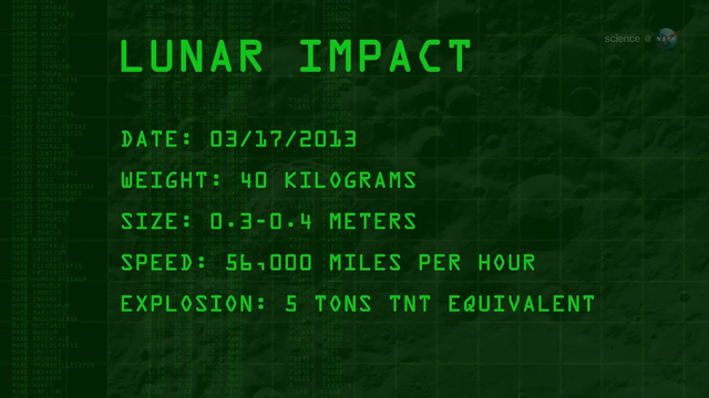
Alt...
A ScienceCast video describes the bright lunar explosion of March 17, 2013.
2019 January 25
Moon Struck
* Image Credit & Copyright: Petr Horálek
https://www.petrhoralek.com/?page_id=20
Explanation:
Craters produced by ancient impacts on the airless Moon have long been a familiar sight. But only since the 1990s have observers began to regularly record and study optical flashes on the lunar surface, likely explosions resulting from impacting meteoroids. Of course, the flashes are difficult to see against a bright, sunlit lunar surface. But during the January 21 total eclipse many imagers serendipitously captured a meteoroid impact flash against the dim red Moon. Found while examining images taken shortly before the total eclipse phase began, the flash is indicated in the inset above, near the Moon's darkened western limb. Estimates based on the flash duration recorded by the Moon Impact Detection and Analysis System (MIDAS) telescopes in southern Spain indicate the impactor's mass was about 10 kilograms and created a crater between seven and ten meters in diameter.
https://www.petrhoralek.com/?p=4458
https://www.scientificamerican.com/article/in-a-first-earthlings-spot-a-meteor-strike-the-eclipse-darkenhttps://spaceweather.com/archive.php?view=1&day=23&month=01&year=2019ed-moon/
https://spaceweathergallery.com/eclipse_gallery.html
https://apod.nasa.gov/apod/ap011208.html
https://apod.nasa.gov/apod/ap190125.html
#space #moon #astrophotography #photography #science #astronomy #nature #NASA #education
 telescopes in southern Spain indicate the impactor's mass was about 10 kilograms and created a crater between seven and ten meters in diameter.
Authors & editors: Robert Nemiroff (MTU) & Jerry Bonnell (UMCP)
NASA Official: Phillip Newman Specific rights apply.
NASA Web Privacy Policy and Important Notices
A service of: ASD at NASA / GSFC
& Michigan Tech. U.")
Alt...
2019 January 25
Moon Struck
* Image Credit & Copyright: Petr Horálek
Explanation:
Craters produced by ancient impacts on the airless Moon have long been a familiar sight. But only since the 1990s have observers began to regularly record and study optical flashes on the lunar surface, likely explosions resulting from impacting meteoroids. Of course, the flashes are difficult to see against a bright, sunlit lunar surface. But during the January 21 total eclipse many imagers serendipitously captured a meteoroid impact flash against the dim red Moon. Found while examining images taken shortly before the total eclipse phase began, the flash is indicated in the inset above, near the Moon's darkened western limb. Estimates based on the flash duration recorded by the Moon Impact Detection and Analysis System (MIDAS) telescopes in southern Spain indicate the impactor's mass was about 10 kilograms and created a crater between seven and ten meters in diameter.
Authors & editors: Robert Nemiroff (MTU) & Jerry Bonnell (UMCP)
NASA Official: Phillip Newman Specific rights apply.
NASA Web Privacy Policy and Important Notices
A service of: ASD at NASA / GSFC
& Michigan Tech. U.
2007 September 1
Kalamalka Lake Eclipse
* Credit & Copyright: Yuichi Takasaka
http://www.blue-moon.ca/
Explanation:
Recorded on August 28th, this serene total lunar eclipse sequence looks southwest down Kalamalka Lake toward the lights of Coldstream, British Columbia. An exposure every 4 minutes captured the Moon's position and eclipse phase, until the Moon set behind the town lights and a hill on the horizon. In fact, the sequence effectively measures the duration of the total phase of the eclipse. Around 270 BC, the Greek astronomer Aristarchus also measured the duration of lunar eclipses - though probably without the benefit of digital clocks and cameras. Still, using geometry, he devised a simple and impressively accurate way to calculate the Moon's distance, in terms of the radius of planet Earth, from the eclipse duration.
http://www.phy6.org/stargaze/Shipprc2.htm
https://www.mreclipse.com/Special/LEprimer.html
https://apod.nasa.gov/apod/ap070901.html
#space #moon #astrophotography #photography #science #astronomy #nature #NASA #education
 & Jerry Bonnell (UMCP)
NASA Official: Phillip Newman Specific rights apply.
NASA Web Privacy Policy and Important Notices
A service of: ASD at NASA / GSFC
& Michigan Tech. U.")
Alt...
2007 September 1
Kalamalka Lake Eclipse
* Credit & Copyright: Yuichi Takasaka
Explanation:
Recorded on August 28th, this serene total lunar eclipse sequence looks southwest down Kalamalka Lake toward the lights of Coldstream, British Columbia. An exposure every 4 minutes captured the Moon's position and eclipse phase, until the Moon set behind the town lights and a hill on the horizon. In fact, the sequence effectively measures the duration of the total phase of the eclipse. Around 270 BC, the Greek astronomer Aristarchus also measured the duration of lunar eclipses - though probably without the benefit of digital clocks and cameras. Still, using geometry, he devised a simple and impressively accurate way to calculate the Moon's distance, in terms of the radius of planet Earth, from the eclipse duration.
Authors & editors: Robert Nemiroff (MTU) & Jerry Bonnell (UMCP)
NASA Official: Phillip Newman Specific rights apply.
NASA Web Privacy Policy and Important Notices
A service of: ASD at NASA / GSFC
& Michigan Tech. U.
2025 September 11
The Umbra of Earth
* Image Credit & Copyright: Wang Letian (Eyes at Night)
http://www.luckwlt.com/About%20Me.html
http://www.luckwlt.com/
Explanation:
The dark, inner shadow of planet Earth is called the umbra. Shaped like a cone extending into space, it has a circular cross section most easily seen during a lunar eclipse. And on the night of September 7/8 the Full Moon passed near the center of Earth's umbral cone, entertaining eclipse watchers around much of our fair planet, including parts of Antarctica, Australia, Asia, Europe, and Africa. Recorded from Zhangjiakou City, China, this timelapse composite image uses successive pictures from the total lunar eclipse, progressing left to right, to reveal the curved cross-section of the umbral shadow sliding across the Moon. Sunlight scattered by the atmosphere into Earth's umbra causes the lunar surface to appear reddened during totality. But close to the umbra's edge, the limb of the eclipsed Moon shows a distinct blue hue. The blue eclipsed moonlight originates as rays of sunlight pass through layers high in the upper stratosphere, colored by ozone that scatters red light and transmits blue. In the total phase of this leisurely lunar eclipse, the Moon was completely within the Earth's umbra for about 83 minutes.
https://science.nasa.gov/moon/eclipses/
https://en.wikipedia.org/wiki/Lunar_eclipse#Total_lunar_eclipse
https://earthsky.org/astronomy-essentials/total-lunar-eclipse-september-7-2025/
https://earthsky.org/astronomy-essentials/total-lunar-eclipse-september-7-2025/
https://apod.nasa.gov/apod/ap250911.html
#space #moon #astrophotography #photography #science #astronomy #nature #NASA #education

Explanation:
The dark, inner shadow of planet Earth is called the umbra. Shaped like a cone extending into space, it has a circular cross section most easily seen during a lunar eclipse. And on the night of September 7/8 the Full Moon passed near the center of Earth's umbral cone, entertaining eclipse watchers around much of our fair planet, including parts of Antarctica, Australia, Asia, Europe, and Africa. Recorded from Zhangjiakou City, China, this timelapse composite image uses successive pictures from the total lunar eclipse, progressing left to right, to reveal the curved cross-section of the umbral shadow sliding across the Moon. Sunlight scattered by the atmosphere into Earth's umbra causes the lunar surface to appear reddened during totality. But close to the umbra's edge, the limb of the eclipsed Moon shows a distinct blue hue. The blue eclipsed moonlight originates as rays of sunlight pass through layers high in the upper stratosphere, colored by ozone that scatters red light and transmits blue. In the total phase of this leisurely lunar eclipse, the Moon was completely within the Earth's umbra for about 83 minutes.
Authors & editors: Robert Nemiroff (MTU) & Jerry Bonnell (UMCP)
NASA Official: Amber Straughn Specific rights apply.
NASA Web Privacy, Accessibility, Notices;
A service of: ASD at NASA / GSFC,
NASA Science Activation
& Michigan Tech. U.")
Alt...
2025 September 11
The Umbra of Earth
* Image Credit & Copyright: Wang Letian (Eyes at Night)
Explanation:
The dark, inner shadow of planet Earth is called the umbra. Shaped like a cone extending into space, it has a circular cross section most easily seen during a lunar eclipse. And on the night of September 7/8 the Full Moon passed near the center of Earth's umbral cone, entertaining eclipse watchers around much of our fair planet, including parts of Antarctica, Australia, Asia, Europe, and Africa. Recorded from Zhangjiakou City, China, this timelapse composite image uses successive pictures from the total lunar eclipse, progressing left to right, to reveal the curved cross-section of the umbral shadow sliding across the Moon. Sunlight scattered by the atmosphere into Earth's umbra causes the lunar surface to appear reddened during totality. But close to the umbra's edge, the limb of the eclipsed Moon shows a distinct blue hue. The blue eclipsed moonlight originates as rays of sunlight pass through layers high in the upper stratosphere, colored by ozone that scatters red light and transmits blue. In the total phase of this leisurely lunar eclipse, the Moon was completely within the Earth's umbra for about 83 minutes.
Authors & editors: Robert Nemiroff (MTU) & Jerry Bonnell (UMCP)
NASA Official: Amber Straughn Specific rights apply.
NASA Web Privacy, Accessibility, Notices;
A service of: ASD at NASA / GSFC,
NASA Science Activation
& Michigan Tech. U.
TOPIC> The Moon
2025 July 20
Lunar Nearside
* Image Credit: NASA / GSFC / Arizona State Univ. / Lunar Reconnaissance Orbiter
https://www.nasa.gov/
https://www.gsfc.nasa.gov/
https://lroc.sese.asu.edu/index.html
Explanation:
About 1,300 images from the Lunar Reconnaissance Orbiter spacecraft's wide angle camera were used to compose this spectacular view of a familiar face - the lunar nearside. But why is there a lunar nearside? The Moon rotates on its axis and orbits the Earth at the same rate, about once every 28 days. Tidally locked in this configuration, the synchronous rotation always keeps one side, the nearside, facing Earth. As a result, featured in remarkable detail in the full resolution mosaic, the smooth, dark, lunar maria (actually lava-flooded impact basins), and rugged highlands, are well-known to earthbound skygazers. To find your favorite mare or large crater, just follow this link or slide your cursor over the picture. The LRO images used to construct the mosaic were recorded over a two week period in December 2010.
https://lroc.im-ldi.com/visit/exhibits/1/gallery/17
https://apod.nasa.gov/apod/ap250720.html
#space #moon #astrophotography #photography #science #astronomy #nature #NASA #ESA #education

CREDIT
NASA/GSFC/Arizona State University
2025 July 20
Lunar Nearside
* Image Credit: NASA / GSFC / Arizona State Univ. / Lunar Reconnaissance Orbiter
Explanation:
About 1,300 images from the Lunar Reconnaissance Orbiter spacecraft's wide angle camera were used to compose this spectacular view of a familiar face - the lunar nearside. But why is there a lunar nearside? The Moon rotates on its axis and orbits the Earth at the same rate, about once every 28 days. Tidally locked in this configuration, the synchronous rotation always keeps one side, the nearside, facing Earth. As a result, featured in remarkable detail in the full resolution mosaic, the smooth, dark, lunar maria (actually lava-flooded impact basins), and rugged highlands, are well-known to earthbound skygazers. To find your favorite mare or large crater, just follow this link or slide your cursor over the picture. The LRO images used to construct the mosaic were recorded over a two week period in December 2010.
Authors & editors: Robert Nemiroff (MTU) & Jerry Bonnell (UMCP)
NASA Official: Amber Straughn Specific rights apply.
NASA Web Privacy, Accessibility, Notices;
A service of: ASD at NASA / GSFC,
NASA Science Activation
& Michigan Tech. U.")
Alt...
Moon Nearside mosaic
The Moon's diameter is 3474 km (2159 miles)
CREDIT
NASA/GSFC/Arizona State University
2025 July 20
Lunar Nearside
* Image Credit: NASA / GSFC / Arizona State Univ. / Lunar Reconnaissance Orbiter
Explanation:
About 1,300 images from the Lunar Reconnaissance Orbiter spacecraft's wide angle camera were used to compose this spectacular view of a familiar face - the lunar nearside. But why is there a lunar nearside? The Moon rotates on its axis and orbits the Earth at the same rate, about once every 28 days. Tidally locked in this configuration, the synchronous rotation always keeps one side, the nearside, facing Earth. As a result, featured in remarkable detail in the full resolution mosaic, the smooth, dark, lunar maria (actually lava-flooded impact basins), and rugged highlands, are well-known to earthbound skygazers. To find your favorite mare or large crater, just follow this link or slide your cursor over the picture. The LRO images used to construct the mosaic were recorded over a two week period in December 2010.
Authors & editors: Robert Nemiroff (MTU) & Jerry Bonnell (UMCP)
NASA Official: Amber Straughn Specific rights apply.
NASA Web Privacy, Accessibility, Notices;
A service of: ASD at NASA / GSFC,
NASA Science Activation
& Michigan Tech. U.

CREDIT
NASA/GSFC/Arizona State University")
Alt...
Annotations Moon Nearside
Same WAC mosaic with major mare and craters labeled. The Moon's diameter is 3474 km (2159 miles)
CREDIT
NASA/GSFC/Arizona State University
2025 June 28
Lunar Farside
* Image Credit: NASA / GSFC / Arizona State Univ. / Lunar Reconnaissance Orbiter
https://www.nasa.gov/
https://www.gsfc.nasa.gov/
https://lroc.sese.asu.edu/index.html
Explanation:
Tidally locked in synchronous rotation, the Moon always presents its familiar nearside to denizens of planet Earth. From lunar orbit, the Moon's farside can become familiar, though. In fact this sharp picture, a mosaic from the Lunar Reconnaissance Orbiter's wide angle camera, is centered on the lunar farside. Part of a global mosaic of over 15,000 images acquired between November 2009 and February 2011, the highest resolution version shows features at a scale of 100 meters per pixel. Surprisingly, the rough and battered surface of the farside looks very different from the nearside covered with smooth dark lunar maria. A likely explanation is that the farside crust is thicker, making it harder for molten material from the interior to flow to the surface and form dark, smooth maria.
https://apod.nasa.gov/apod/ap250628.html
#space #moon #astrophotography #photography #science #astronomy #nature #NASA #ESA #education
 & Jerry Bonnell (UMCP)
NASA Official: Amber Straughn Specific rights apply.
NASA Web Privacy, Accessibility, Notices;
A service of: ASD at NASA / GSFC,
NASA Science Activation
& Michigan Tech. U.")
Alt...
The lunar farside as never seen before! LROC WAC orthographic projection centered at 180° longitude, 0° latitude
CREDIT
NASA/GSFC/Arizona State University
2025 June 28
Lunar Farside
* Image Credit: NASA / GSFC / Arizona State Univ. / Lunar Reconnaissance Orbiter
Explanation:
Tidally locked in synchronous rotation, the Moon always presents its familiar nearside to denizens of planet Earth. From lunar orbit, the Moon's farside can become familiar, though. In fact this sharp picture, a mosaic from the Lunar Reconnaissance Orbiter's wide angle camera, is centered on the lunar farside. Part of a global mosaic of over 15,000 images acquired between November 2009 and February 2011, the highest resolution version shows features at a scale of 100 meters per pixel. Surprisingly, the rough and battered surface of the farside looks very different from the nearside covered with smooth dark lunar maria. A likely explanation is that the farside crust is thicker, making it harder for molten material from the interior to flow to the surface and form dark, smooth maria.
Authors & editors: Robert Nemiroff (MTU) & Jerry Bonnell (UMCP)
NASA Official: Amber Straughn Specific rights apply.
NASA Web Privacy, Accessibility, Notices;
A service of: ASD at NASA / GSFC,
NASA Science Activation
& Michigan Tech. U.

Alt...
Annotations for the lunar farside.
LROC WAC orthographic projection centered at 180° longitude, 0° latitude
CREDIT
NASA/GSFC/Arizona State University
* The annotations are still unofficial
Tidal locking
results in the Moon rotating about its axis in about the same time it takes to orbit the Earth. Except for libration effects, this results in it keeping the same face turned towards the Earth, as seen in the figure on the upper left. (The Moon is shown in polar view, and is not drawn to scale.)
+ Upper left:
> If the Moon didn't spin at all, then it would alternately show its near and far sides to the Earth while moving around our planet in orbit.
+ Upper right:
> If rotational frequency is larger than orbital frequency, a small torque counteracting the rotation arises, eventually locking the frequencies (situation depicted in green)
+ Down left:
> A simulation shows the variability in the portion of the Moon visible from Earth due to libration over the course of an orbit. Lighting phases from the Sun are not included.
+ Down right:
> Animation of the Moon as it cycles through its phases. The apparent wobbling of the Moon is known as libration
From Wikipedia, the free encyclopedia
CREDITS
Contributors to Wikimedia projects
* Stigmatella aurantiaca
* Jim McKeeth
* Tom Ruen
* Poopooman-ger
#space #moon #astrophotography #photography #science #astronomy #nature #NASA #ESA #education
Alt...
At left, the Moon rotates at the same rate it orbits the Earth, keeping the same face toward the planet. At right, if the Moon did not rotate then the face would change over the course of an orbit. Viewed from above; not to scale.
CREDIT
Stigmatella aurantiaca

CREDIT
Jim McKeeth")
Alt...
If rotational frequency is larger than orbital frequency, a small torque counteracting the rotation arises, eventually locking the frequencies (situation depicted in green)
CREDIT
Jim McKeeth
Alt...
This simulation shows the variability in the portion of the Moon visible from Earth due to libration over the course of an orbit. Lighting phases from the Sun are not included.
One anomalistic lunar cycle (Apogee to Apogee) for April 2007. No phase shown.
CREDIT
Tom Ruen - Own work, created with "Full Sky Observatory" Source bitmap for projection from Nasa's Clementine Spacecraft: USGS: Global simple cylindrical projection at 10 km/pixel. Software: "Full Sky Observatory", by Tom Ruen, described at File:FullSkyAstronomySoftwareLogo.png Source book: "Astronomical Formulae for Calculators, 4th edition", Jean Meeus, 1988, published by "Willmann-Bell, Inc" Chapter 30 "Position of the Moon"
Alt...
Animation of the Moon as it cycles through its phases. The apparent wobbling of the Moon is known as libration.
CREDIT
Poopooman-ger
Orbit the Moon! - LROC WAC Global Mosaic and DTM
The Lunar Reconnaissance Orbiter Camera (LROC) WAC is a push-frame camera that captures seven color bands (321, 360, 415, 566, 604, 643, and 689 nm) with a 57-km swath (105-km swath in monochrome mode) from a 50 km orbit. One of the primary objectives of LROC is to provide a global 100 m/pixel monochrome (643 nm) base map with incidence angles between 55°-70° at the equator, lighting that is favorable for morphological interpretations. Each month, the WAC provides nearly complete coverage of the Moon under unique lighting. As an added bonus, the orbit-to-orbit image overlap provides stereo coverage. Reducing all these stereo images into a global topographic map is a big job, and is being led by LROC Team Members from the German Aerospace Center (Deutsches Zentrum für Luft- und Raumfahrt; DLR). Several preliminary WAC topographic products have appeared in LROC featured images (Orientale basin, Sinus Iridum). For a sneak preview of the WAC global DEM with the WAC global mosaic, view a rotating composite Moon (Full Res).
The global mosaic comprised of over 15,000 WAC images acquired between November 2009 and February 2011. The non-polar images were map projected onto the GLD100 shape model (WAC derived 100 m/pixel DTM), while polar images were map projected on the LOLA shape model. In addition, the LOLA derived crossover corrected ephemeris, and improved camera pointing, provide accurate positioning (100 m) of each WAC image.
CREDIT
LROC
WAC
DLR
https://lroc.im-ldi.com/images/298
#space #moon #astrophotography #photography #science #astronomy #nature #NASA #ESA #education
Alt...
LROC WAC Global Mosaic and DTM
The Lunar Reconnaissance Orbiter Camera (LROC) WAC is a push-frame camera that captures seven color bands (321, 360, 415, 566, 604, 643, and 689 nm) with a 57-km swath (105-km swath in monochrome mode) from a 50 km orbit. One of the primary objectives of LROC is to provide a global 100 m/pixel monochrome (643 nm) base map with incidence angles between 55°-70° at the equator, lighting that is favorable for morphological interpretations. Each month, the WAC provides nearly complete coverage of the Moon under unique lighting. As an added bonus, the orbit-to-orbit image overlap provides stereo coverage. Reducing all these stereo images into a global topographic map is a big job, and is being led by LROC Team Members from the German Aerospace Center (Deutsches Zentrum für Luft- und Raumfahrt; DLR). Several preliminary WAC topographic products have appeared in LROC featured images (Orientale basin, Sinus Iridum). For a sneak preview of the WAC global DEM with the WAC global mosaic, view a rotating composite Moon (Full Res).
The global mosaic comprised of over 15,000 WAC images acquired between November 2009 and February 2011. The non-polar images were map projected onto the GLD100 shape model (WAC derived 100 m/pixel DTM), while polar images were map projected on the LOLA shape model. In addition, the LOLA derived crossover corrected ephemeris, and improved camera pointing, provide accurate positioning (100 m) of each WAC image.
CREDIT
LROC
WAC
DLR
"I'm sorry for you Mastodon users due to insufficiently configured software on your server side you unfortunately only see a third of the displayed images. I can expressly recommend the platform defcon.social to scientifically and creatively interested and committed users of the Fediverse."
Moon Phases
In our entire solar system, the only object that shines with its own light is the Sun. That light always beams onto Earth and Moon from the direction of the Sun, illuminating half of our planet in its orbit and reflecting off the surface of the Moon to create moonlight. Sometimes the entire face of the Moon glows brightly. Other times we see only a thin crescent of light. Sometimes the Moon seems to disappear. These shifts are called moon phases.
The eight lunar phases are, in order: new moon, waxing crescent, first quarter, waxing gibbous, full moon, waning gibbous, third quarter, and waning crescent. The cycle repeats about once a month (every 29.5 days).
Like Earth, the Moon has a day side and a night side, which change as the Moon rotates. The Sun always illuminates half of the Moon while the other half remains dark, but how much we are able to see of that illuminated half changes as the Moon travels through its orbit.
Images:
1.
Position of the Moon and the Sun during each of the Moon’s phases
2. - 9.
All Moon Phases
Let’s take a look at the individual phases, and how the movements of the Moon and Sun appear to us as we watch from the Northern Hemisphere on Earth.
10.
Overview From Space
The Moon orbits Earth from a viewpoint above the North Pole in this animation. The blue gridlines show how the same side of the Moon always faces Earth. The size of the Earth and Moon are enlarged 20 times.
CREDITS:
* NASA's Scientific Visualization Studio
* NASA/JPL-Caltech
https://science.nasa.gov/moon/moon-phases/
#space #moon #astrophotography #photography #science #astronomy #nature #NASA #ESA #education #fediverse #mastodon #defconsocial

Alt...
This graphic shows the position of the Moon and the Sun during each of the Moon’s phases and the Moon as it appears from Earth during each phase.
CREDIT
NASA/JPL-Caltech

Alt...
New Moon
This is the invisible phase of the Moon, with the illuminated side of the Moon facing the Sun and the night side facing Earth. In this phase, the Moon is in the same part of the sky as the Sun and rises and sets with the Sun. Not only is the illuminated side facing away from the Earth, it’s also up during the day! Remember, in this phase, the Moon doesn’t usually pass directly between Earth and the Sun, due to the inclination of the Moon’s orbit. It only passes near the Sun from our perspective on Earth.
CREDIT
NASA/JPL-Caltech

Alt...
Waxing Crescent
This silver sliver of a Moon occurs when the illuminated half of the Moon faces mostly away from Earth, with only a tiny portion visible to us from our planet. It grows daily as the Moon’s orbit carries the Moon’s dayside farther into view. Every day, the Moon rises a little bit later.
CREDIT
NASA/JPL-Caltech

Alt...
First Quarter
The Moon is now a quarter of the way through its monthly journey and you see half of its illuminated side. People may casually call this a half moon, but remember, that’s not really what you’re witnessing in the sky. You’re seeing just a slice of the entire Moon ― half of the illuminated half. A first quarter moon rises around noon and sets around midnight. It’s high in the sky in the evening and makes for excellent viewing.
CREDIT
NASA/JPL-Caltech

Alt...
Waxing Gibbous
Now most of the Moon’s dayside has come into view, and the Moon appears brighter in the sky.
CREDIT
NASA/JPL-Caltech
. The Moon is opposite the Sun, as viewed from Earth, revealing the Moon’s dayside. A full moon rises around sunset and sets around sunrise. The Moon will appear full for a couple of days before it moves into…
CREDIT
NASA/JPL-Caltech")
Alt...
Full Moon
This is as close as we come to seeing the Sun’s illumination of the entire day side of the Moon (so, technically, this would be the real half moon). The Moon is opposite the Sun, as viewed from Earth, revealing the Moon’s dayside. A full moon rises around sunset and sets around sunrise. The Moon will appear full for a couple of days before it moves into…
CREDIT
NASA/JPL-Caltech

Alt...
Waning Gibbous
As the Moon begins its journey back toward the Sun, the opposite side of the Moon now reflects the Moon’s light. The lighted side appears to shrink, but the Moon’s orbit is simply carrying it out of view from our perspective. The Moon rises later and later each night.
CREDIT
NASA/JPL-Caltech

Alt...
Last Quarter
The Moon looks like it’s half illuminated from the perspective of Earth, but really you’re seeing half of the half of the Moon that’s illuminated by the Sun ― or a quarter. A last quarter moon, also known as a third quarter moon, rises around midnight and sets around noon.
CREDIT
NASA/JPL-Caltech

Alt...
Waning Crescent
The Moon is nearly back to the point in its orbit where its dayside directly faces the Sun, and all that we see from our perspective is a thin curve.
CREDIT
NASA/JPL-Caltech
Alt...
The Moon orbits Earth from a viewpoint above the North Pole in this animation. The blue gridlines show how the same side of the Moon always faces Earth. The size of the Earth and Moon are enlarged 20 times.
Overview From Space
Imagine you’re in a spaceship, traveling away from Earth. As you sail onward, you see our planet and its Moon locked together in their endless, circling, gravitational embrace. Your distant view gives you a unique perspective on the Moon that can be hard to visualize from the ground, where the Moon appears to sweep through the sky as an ever-changing globe of light.
From your astronaut’s viewpoint, you can see that the Moon is an average of 238,855 miles (384,399 km) from Earth, or about the space that could be occupied by 30 Earths. It travels around our planet once every 27.322 days in an elliptical orbit, an elongated circle. (It takes about 27.3 days to complete a revolution, but 29.5 days to change from new moon to new moon.) The Moon is tidally locked with Earth, which means that it spins on its axis exactly once each time it orbits our planet. Because of this, people on Earth only ever see one side of the Moon. We call this motion synchronous rotation.
CREDIT:
NASA's Scientific Visualization Studio
"Hello my dear moon addicts, I hope you enjoy this year's moon phases as much as I do. The best thing to do is to put on headphones, adopt a comfortable posture and a chilled drink would also be the order of the day, enjoy!"
This wonderful visualization shows the Moon's phase and libration at hourly intervals throughout 2025, as viewed from the Northern Hemisphere. Each frame represents one hour. In addition, this visualization shows the Moon's orbit position, sub-Earth and subsolar points, and distance from the Earth at true scale. Craters near the terminator are labeled, as are Apollo landing sites, maria, and other albedo features in sunlight.
https://svs.gsfc.nasa.gov/5415
https://svs.gsfc.nasa.gov/5415
* Video credit:
NASA’s Goddard Space Flight Center
* Data visualization by: Ernie Wright (USRA)
* Producer & Editor: James Tralie
* Music Provided by Universal Production Music: "Shine a Light," "Space and Time," and "Spiralling Stars" by Timothy James Cornick
#space #moon #astrophotography #photography #science #astronomy #nature #NASA #ESA #education
The main Moon phases
Diagram of the main lunar phases. With the Sun assumed to be far off to the right, the inner circle shows the positions of the Moon as seen from above Earth’s North Pole that correspond to the phases of the Moon that we see from Earth as shown on the outer circle.
When the Moon is in other different positions in its orbit around Earth, it will appear as a crescent and other partial shapes. As the Moon shifts from new Moon to full Moon — as it moves to where we can see more of the part brightened by the Sun — we say the Moon is waxing. During the other half of the time, when the Moon is passing from full Moon to new Moon, we say the Moon is waning.
There can also be “supermoons”. Because the Moon’s orbit is slightly oblong instead of a perfect circle, there are times when the Moon is closer to Earth than usual and appears larger in the sky. When that also coincides with full Moon or new Moon, it’s called a supermoon. A supermoon will look slightly larger than normal, but the change is not big enough to be obvious to the naked eye.
CREDIT
NASA
https://www.planetary.org/space-images/the-main-moon-phases
#space #moon #astrophotography #photography #science #astronomy #nature #NASA #ESA #education

Alt...
The main Moon phases
Diagram of the main lunar phases, not to scale. With the Sun assumed to be far off to the right, the inner circle shows the positions of the Moon as seen from above Earth’s North Pole that correspond to the phases of the Moon that we see from Earth as shown on the outer circle.
CREDIT
NASA
Lunar eclipse
A lunar eclipse is an astronomical event that occurs when the Moon moves into the Earth's shadow, causing the Moon to be darkened. Such an alignment occurs during an eclipse season, approximately every six months, during the full moon phase, when the Moon's orbital plane is closest to the plane of the Earth's orbit.
This can occur only when the Sun, Earth, and Moon are exactly or very closely aligned (in syzygy) with Earth between the other two, which can happen only on the night of a full moon when the Moon is near either lunar node. The type and length of a lunar eclipse depend on the Moon's proximity to the lunar node.
When the Moon is totally eclipsed by the Earth (a "deep eclipse"), it takes on a reddish color that is caused by the planet when it completely blocks direct sunlight from reaching the Moon's surface, as the only light that is reflected from the lunar surface is what has been refracted by the Earth's atmosphere. This light appears reddish due to the Rayleigh scattering of blue light, the same reason sunrises and sunsets are more orange than during the day.
Unlike a solar eclipse, which can only be viewed from a relatively small area of the world, a lunar eclipse may be viewed from anywhere on the night side of Earth. A total lunar eclipse can last up to nearly two hours (while a total solar eclipse lasts only a few minutes at any given place) because the Moon's shadow is smaller. Also unlike solar eclipses, lunar eclipses are safe to view without any eye protection or special precautions.
TEXT
From Wikipedia, the free encyclopedia
VIDEO
Lunar Eclipse Essentials
Explainer Video about Lunar Eclipses
Updated April 22, 2022
Credit
* Scientific Visualization Studio/NASA
* Goddard Space Flight Center.
* Lead Producer: Chris Smith.
* Lead Visualizer: Ernie Wright.
* Producer: David Ladd.
* Technical Support: Aaron Lepsch.
#space #moon #astrophotography #photography #science #astronomy #nature #NASA #ESA #education
Alt...
Lunar Eclipse Essentials
Explainer Video about Lunar Eclipses
April 22, 2022
Credit
* Scientific Visualization Studio/NASA
* Goddard Space Flight Center.
* Lead Producer: Chris Smith.
* Lead Visualizer: Ernie Wright.
* Producer: David Ladd.
* Technical Support: Aaron Lepsch.
2025 August 30
A Two Percent Moon
* Image Credit & Copyright: Marina Prol
https://www.marinaprol.com/
Explanation:
A young crescent moon can be hard to see. That's because when the Moon shows it's crescent phase (young or old) it can never be far from the Sun in planet Earth's sky. And even though the sky is still bright, a slender sunlit lunar crescent is cleary visible in this early evening skyscape. The telephoto snapshot was captured on August 24, with the Moon very near the western horizon at sunset. Seen in a narrow crescent phase about 1.5 days old, the visible sunlit portion is a mere two percent of the surface of the Moon's familiar nearside. At the Canary Islands Space Centre, a steerable radio dish for communication with spacecraft is titled in the direction of the two percent Moon. The sunset sky's pastel pinkish coloring is partly due to fine sand and dust from the Sahara Desert blown by the prevailing winds.
https://svs.gsfc.nasa.gov/5415/
https://science.nasa.gov/skywatching/
https://apod.nasa.gov/apod/ap080411.html
https://apod.nasa.gov/apod/ap250830.html
#space #moon #astrophotography #photography #science #astronomy #nature #NASA #ESA #education
 it can never be far from the Sun in planet Earth's sky. And even though the sky is still bright, a slender sunlit lunar crescent is cleary visible in this early evening skyscape. The telephoto snapshot was captured on August 24, with the Moon very near the western horizon at sunset. Seen in a narrow crescent phase about 1.5 days old, the visible sunlit portion is a mere two percent of the surface of the Moon's familiar nearside. At the Canary Islands Space Centre, a steerable radio dish for communication with spacecraft is titled in the direction of the two percent Moon. The sunset sky's pastel pinkish coloring is partly due to fine sand and dust from the Sahara Desert blown by the prevailing winds.
Authors & editors: Robert Nemiroff (MTU) & Jerry Bonnell (UMCP)
NASA Official: Amber Straughn Specific rights apply.
NASA Web Privacy, Accessibility, Notices;
A service of: ASD at NASA / GSFC,
NASA Science Activation
& Michigan Tech. U.")
Alt...
2025 August 30
A Two Percent Moon
* Image Credit & Copyright: Marina Prol
Explanation:
A young crescent moon can be hard to see. That's because when the Moon shows it's crescent phase (young or old) it can never be far from the Sun in planet Earth's sky. And even though the sky is still bright, a slender sunlit lunar crescent is cleary visible in this early evening skyscape. The telephoto snapshot was captured on August 24, with the Moon very near the western horizon at sunset. Seen in a narrow crescent phase about 1.5 days old, the visible sunlit portion is a mere two percent of the surface of the Moon's familiar nearside. At the Canary Islands Space Centre, a steerable radio dish for communication with spacecraft is titled in the direction of the two percent Moon. The sunset sky's pastel pinkish coloring is partly due to fine sand and dust from the Sahara Desert blown by the prevailing winds.
Authors & editors: Robert Nemiroff (MTU) & Jerry Bonnell (UMCP)
NASA Official: Amber Straughn Specific rights apply.
NASA Web Privacy, Accessibility, Notices;
A service of: ASD at NASA / GSFC,
NASA Science Activation
& Michigan Tech. U.
https://www.youtube.com/watch?v=TNhtAh3U_sc&list=RDTNhtAh3U_sc&start_radio=1
https://en.wikipedia.org/wiki/The_Pentateuch_of_the_Cosmogony
https://www.progarchives.com/Review.asp?id=78341
https://www.independent.co.uk/news/obituaries/patrick-woodroffe-fantasy-artist-who-illustrated-sciencefiction-books-and-album-covers-9647922.html