Search results for tag #space
![[?]](https://files.defcon.social/dcsocial-s3/accounts/avatars/113/208/344/507/078/943/original/014820ad22daee1c.jpg)
April 6, 2011
Dry Ice on Mars
by Melody
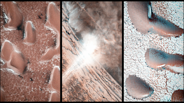
On Mars the seasonal polar caps are composed of dry ice (carbon dioxide). In the springtime as the sun shines on the ice, it turns from solid to gas and causes erosion of the surface. Dry ice goes directly from solid to vapor, unlike water ice which melts into liquid when it gets warm.
On Mars the seasonal polar caps are composed of dry ice (carbon dioxide). In the springtime as the sun shines on the ice, it turns from solid to gas and causes erosion of the surface. I enjoy the incredible diversity of forms that the erosion takes, and am studying the factors that give us "spiders", "caterpillars", or "starbursts", all colloquial words for what we rigorously name "araneiform" terrain.
This particular example shows eroded channels filled with bright ice, in contrast to the muted red of the underlying ground. In the summer the ice will disappear into the atmosphere, and we will see just the channels of ghostly spiders carved in the surface. This is truly Martian terrain - this type of erosion does not take place anywhere naturally on earth because our climate is too warm.
Credit:
NASA/JPL/University of Arizona
#space #mars #astrophotography #photography #science #astronomy #nature #NASA
 camera on the Mars Reconnaissance Orbiter on Jan. 12, 2011.")
Alt...
Dry Ice on Mars
Spidery ice formations on the surface of Mars as seen from orbit.
This image was taken with the High Resolution Imaging Science Experiment (HiRISE) camera on the Mars Reconnaissance Orbiter on Jan. 12, 2011.
Oct. 26, 2023
Distribution of Buried Ice on Mars
These Mars global maps show the likely distribution of water ice buried within the upper 3 feet (1 meter) of the planet's surface and represent the latest data from the Subsurface Water Ice Mapping project, or SWIM. SWIM uses data acquired by science instruments aboard three NASA orbital missions to estimate where ice may be hiding below the surface. Superimposed on the globes are the locations of ice-exposing meteoroid impacts, which provide an independent means to test the mapping results.
The ice-exposing impacts were spotted by the High-Resolution Imaging Science Experiment (HiRISE), a camera aboard NASA's Mars Reconnaissance Orbiter. While other instruments at Mars can only suggest where buried water ice is located, HiRISE's imagery of ice-exposing impacts can confirm where ice is present.
Most of these craters are no more than 33 feet (10 meters) in diameter, although in 2022 HiRISE captured a 492-foot-wide (150-meter-wide) impact crater that revealed a motherlode of ice that had been hiding beneath the surface. This crater is indicated with a circle in the upper-left portion of the right-most globe above.
Scientists can use mapping data like this to decide where the first astronauts on Mars should land: Buried ice will be a vital resource for the first people to set foot on Mars, serving as drinking water and a key ingredient for rocket fuel. It would also be a major scientific target: Astronauts or robots could one day drill ice cores much as scientists do on Earth, uncovering the climate history of Mars and exploring potential habitats (past or present) for microbial life.
Credit:
NASA Jet Propulsion Laboratory (JPL)
#space #mars #science #astronomy #physics #geology #nature #education #NASA
 of the planet's surface and represent the latest data from the Subsurface Water Ice Mapping project, or SWIM. SWIM uses data acquired by science instruments aboard three NASA orbital missions to estimate where ice may be hiding below the surface. Superimposed on the globes are the locations of ice-exposing meteoroid impacts, which provide an independent means to test the mapping results.
The need to look for subsurface ice arises because liquid water isn't stable on the Martian surface: The atmosphere is so thin that water immediately vaporizes. There's plenty of ice at the Martian poles – mostly made of water, although carbon dioxide, or dry ice, can be found as well – but those regions are too cold for astronauts (or robots) to survive for long.")
Alt...
Distribution of Buried Ice on Mars
Oct. 26, 2023
These Mars global maps show the likely distribution of water ice buried within the upper 3 feet (1 meter) of the planet's surface and represent the latest data from the Subsurface Water Ice Mapping project, or SWIM. SWIM uses data acquired by science instruments aboard three NASA orbital missions to estimate where ice may be hiding below the surface. Superimposed on the globes are the locations of ice-exposing meteoroid impacts, which provide an independent means to test the mapping results.
The need to look for subsurface ice arises because liquid water isn't stable on the Martian surface: The atmosphere is so thin that water immediately vaporizes. There's plenty of ice at the Martian poles – mostly made of water, although carbon dioxide, or dry ice, can be found as well – but those regions are too cold for astronauts (or robots) to survive for long.
Dec 20, 2024
Avalanches, Icy Explosions, and Dunes:
NASA Is Tracking New Year on Mars
By NASA
[...]
“Springtime on Earth has lots of trickling as water ice gradually melts. But on Mars, everything happens with a bang,” said Serina Diniega, who studies planetary surfaces at NASA’s Jet Propulsion Laboratory in Southern California.
Mars’ wispy atmosphere doesn’t allow liquids to pool on the surface, like on Earth. Instead of melting, ice sublimates, turning directly into a gas. The sudden transition in spring means a lot of violent changes as both water ice and carbon dioxide ice — dry ice, which is much more plentiful on Mars than frozen water — weaken and break.
[...]
Using the cameras and other sensors aboard NASA’s Mars Reconnaissance Orbiter (MRO), which launched in 2005, scientists study all this activity to improve their understanding of the forces shaping the dynamic Martian surface. Here’s some of what they track.
In 2015, MRO’s High-Resolution Imaging Science Experiment (HiRISE) camera captured a 66-foot-wide (20-meter-wide) chunk of carbon dioxide frost in freefall. Chance observations like this are reminders of just how different Mars is from Earth, Diniega said, especially in springtime, when these surface changes are most noticeable.
[...]
Diniega has relied on HiRISE to study another quirk of Martian springtime: gas geysers that blast out of the surface, throwing out dark fans of sand and dust. These explosive jets form due to energetic sublimation of carbon dioxide ice. As sunlight shines through the ice, its bottom layers turn to gas, building pressure until it bursts into the air, creating those dark fans of material.
But to see the best examples of the newest fans, researchers will have to wait until December 2025, when spring starts in the southern hemisphere. There, the fans are bigger and more clearly defined.
[...]
#space #mars #astrophotography #photography #science #astronomy #physics #nature #NASA
Alt...
It’s a new year on Mars, and while New Year’s means winter in Earth’s northern hemisphere, it’s the start of spring in the same region of the Red Planet. And that means ice is thawing, leading to all sorts of interesting things. JPL research scientist Serina Diniega explains. NASA/JPL-Caltech
2025 July 6
The Spiral North Pole of Mars
* Image Credit: ESA/DLR/FU Berlin; NASA MGS MOLA Science Team
http://www.esa.int/
http://www.dlr.de/pf/
http://www.fu-berlin.de/
https://www.nasa.gov/
https://mars.nasa.gov/programmissions/missions/past/globalsurveyor/
https://attic.gsfc.nasa.gov/mola/
Explanation:
Why is there a spiral around the North Pole of Mars? Each winter this pole develops a new outer layer about one meter thick composed of carbon dioxide frozen out of the thin Martian atmosphere. This fresh layer is deposited on a water-ice layer that exists year round. Strong winds blow down from above the cap's center and swirl due to the spin of the red planet -- contributing to Planum Boreum's spiral structure. The featured image is a perspective mosaic generated in 2017 from numerous images taken by ESA's Mars Express and elevations extracted from the laser altimeter aboard NASA's Mars Global Surveyor mission.
https://www.esa.int/ESA_Multimedia/Images/2017/02/Perspective_view_of_Mars_north_polar_ice_cap
!>>https://ilrs.gsfc.nasa.gov/lw16/docs/presentations/sci_6_Smith.pdf
https://en.wikipedia.org/wiki/Planum_Boreum
https://en.wikipedia.org/wiki/Katabatic_wind
https://apod.nasa.gov/apod/ap250706.html
#space #mars #astrophotography #photography #science #astronomy #geology #nature #NASA
 & Jerry Bonnell (UMCP)
NASA Official: Amber Straughn Specific rights apply.
NASA Web Privacy, Accessibility, Notices;
A service of: ASD at NASA / GSFC,
NASA Science Activation
& Michigan Tech. U.")
Alt...
2025 July 6
A computer construction of what the north pole of Mars looks like. The picture was constructed from measured altitude data. A spiral landscape is seen that is colored red but is mostly covered with white ice.
The Spiral North Pole of Mars
* Image Credit: ESA/DLR/FU Berlin; NASA MGS MOLA Science Team
Explanation:
Why is there a spiral around the North Pole of Mars? Each winter this pole develops a new outer layer about one meter thick composed of carbon dioxide frozen out of the thin Martian atmosphere. This fresh layer is deposited on a water-ice layer that exists year round. Strong winds blow down from above the cap's center and swirl due to the spin of the red planet -- contributing to Planum Boreum's spiral structure. The featured image is a perspective mosaic generated in 2017 from numerous images taken by ESA's Mars Express and elevations extracted from the laser altimeter aboard NASA's Mars Global Surveyor mission.
Authors & editors: Robert Nemiroff (MTU) & Jerry Bonnell (UMCP)
NASA Official: Amber Straughn Specific rights apply.
NASA Web Privacy, Accessibility, Notices;
A service of: ASD at NASA / GSFC,
NASA Science Activation
& Michigan Tech. U.
"27 years ago, the first 3D visualizations of the North Pole of Mars were published and if you take into account the technical possibilities at that time and the resulting state of knowledge, then this image was a world sensation"
December 16, 1998
3-D Mars' North Pole
* Credit: MOLA Team, MGS Project, NASA
* Image: Greg Shirah (SVS)
Explanation:
This dramatic premier three-dimensional visualization of Mars' north pole is based on elevation measurements made by an orbiting laser. During the Spring and Summer of 1998 the Mars Orbiter Laser Altimeter (MOLA) flashed laser pulses toward the Martian surface from the Global Surveyor spacecraft and recorded the time it took to detect the reflection. This timing data has now been translated to a detailed topographic map of Mars' north polar terrain. The map indicates that the ice cap is is about 1,200 kilometers across, a maximum of 3 kilometers thick, and cut by canyons and troughs up to 1 kilometer deep. The measurements also indicate that the cap is composed primarily of water ice with a total volume of only about four percent of planet Earth's Antarctic ice sheet. In all it represents at most a tenth of the amount of water some scientists believe once existed on ancient Mars. Where did all the water go?
https://ilrs.gsfc.nasa.gov/lw16/docs/presentations/sci_6_Smith.pdf
https://apod.nasa.gov/apod/ap981216.html
#space #mars #astrophotography #photography #science #astronomy #geology #history #nature #NASA

Explanation:
This dramatic premier three-dimensional visualization of Mars' north pole is based on elevation measurements made by an orbiting laser. During the Spring and Summer of 1998 the Mars Orbiter Laser Altimeter (MOLA) flashed laser pulses toward the Martian surface from the Global Surveyor spacecraft and recorded the time it took to detect the reflection. This timing data has now been translated to a detailed topographic map of Mars' north polar terrain. The map indicates that the ice cap is is about 1,200 kilometers across, a maximum of 3 kilometers thick, and cut by canyons and troughs up to 1 kilometer deep. The measurements also indicate that the cap is composed primarily of water ice with a total volume of only about four percent of planet Earth's Antarctic ice sheet. In all it represents at most a tenth of the amount of water some scientists believe once existed on ancient Mars. Where did all the water go?
Authors & editors: Robert Nemiroff (MTU) & Jerry Bonnell (USRA)
NASA Technical Rep.: Jay Norris. Specific rights apply.
A service of: LHEA at NASA/ GSFC
&: Michigan Tech. U.")
Alt...
December 16, 1998
3-D Mars' North Pole
* Credit: MOLA Team, MGS Project, NASA
* Image: Greg Shirah (SVS)
Explanation:
This dramatic premier three-dimensional visualization of Mars' north pole is based on elevation measurements made by an orbiting laser. During the Spring and Summer of 1998 the Mars Orbiter Laser Altimeter (MOLA) flashed laser pulses toward the Martian surface from the Global Surveyor spacecraft and recorded the time it took to detect the reflection. This timing data has now been translated to a detailed topographic map of Mars' north polar terrain. The map indicates that the ice cap is is about 1,200 kilometers across, a maximum of 3 kilometers thick, and cut by canyons and troughs up to 1 kilometer deep. The measurements also indicate that the cap is composed primarily of water ice with a total volume of only about four percent of planet Earth's Antarctic ice sheet. In all it represents at most a tenth of the amount of water some scientists believe once existed on ancient Mars. Where did all the water go?
Authors & editors: Robert Nemiroff (MTU) & Jerry Bonnell (USRA)
NASA Technical Rep.: Jay Norris. Specific rights apply.
A service of: LHEA at NASA/ GSFC
&: Michigan Tech. U.
Some laser-based toporaphic views of the surface of Mars
#space #mars #astrophotography #photography #science #astronomy #geology #topography #nature #NASA
")
Alt...
This is a Global topographic map of Mars with major surface features labeled. (Credit: MOLA Science Team)
. These maps are orthographic projections that contain over 200,000,000 points and about 5,000,000 altimetric crossovers. The spatial resolution is about 15 kilometers at the equator and less at higher latitudes. The vertical accuracy is less than 5 meters.")
Alt...
Global false-color topographic views of Mars from the Mars Orbiter Laser Altimeter (MOLA). These maps are orthographic projections that contain over 200,000,000 points and about 5,000,000 altimetric crossovers. The spatial resolution is about 15 kilometers at the equator and less at higher latitudes. The vertical accuracy is less than 5 meters.
Cappuccino swirls at Mars’ south pole
This picture is, perhaps surprisingly, from ESA’s Mars Express, which has been exploring and imaging the martian surface and atmosphere since 2003. We may be used to seeing numerous images of red and brown-hued soil and ruddy landscapes peppered with craters, but the Red Planet isn’t always so red.
The bright white region of this image shows the icy cap that covers Mars’ south pole, composed of frozen water and carbon dioxide. While it looks smooth in this image, at close quarters the cap is a layered mix of peaks, troughs and flat plains, and has been likened in appearance to swiss cheese.
The southern cap reaches some 3 km thick in places, and is around 350 km in diameter. This icy region is permanent; in the martian winter another, thinner ice cap forms over the top of it, stretching further out across the planet and disappearing again when the weather warms up.
The cap is around 150 km north of Mars’ geographical south pole and Mars Express has shed light on why this ice cap is displaced. Deep impact craters – notably the Hellas Basin, the largest impact structure on the entire planet at 7 km deep and 2300 km across – funnel the strong winds that blow across Mars towards its southern pole, creating a mix of different low- and high-pressure systems. The carbon dioxide in the polar cap sublimates at different rates in these regions with contrasting pressure, resulting in the cap’s lopsided structure.
Mars Express imaged this area of Mars on 17 December 2012, in infrared, green and blue light, using its High Resolution Stereo Camera. This image was processed by Bill Dunford, using data available from the ESA Planetary Science Archive.
CREDIT
ESA/DLR/FU Berlin / Bill Dunford
#space #mars #astrophotography #photography #science #astronomy #geology #topography #nature #NASA

Alt...
Swirls of chocolate, caramel and cream – this image is definitely one to trigger sweet-toothed cravings. Smooth cream-coloured plateaus surrounded by cocoa-dusted ridges interspersed with caramel-hued streaks create a scene reminiscent of a cosmic cappuccino.
This picture is, perhaps surprisingly, from ESA’s Mars Express, which has been exploring and imaging the martian surface and atmosphere since 2003. We may be used to seeing numerous images of red and brown-hued soil and ruddy landscapes peppered with craters, but the Red Planet isn’t always so red.
CREDIT
ESA/DLR/FU Berlin / Bill Dunford
Upper surface of icy layers covering Mars' south-polar region
This map shows the topography of the south polar region of Mars. The data were collected by the Mars Orbiter Laser Altimeter (MOLA) aboard NASA’s Mars Global Surveyor orbiter between 1997 and 2001.
The elevation of the terrain is shown by colors, with purple and blue representing the lowest areas, and orange and red the highest. The total range of elevation shown is about 5 kilometres. The black line shows the boundary of the south polar layered deposits, an ice-rich geologic unit that was probed by the Mars Advanced Radar for Subsurface and Ionospheric Sounding (MARSIS) aboard the European Space Agency's Mars Express orbiter between 2005 and 2006.
The radar data indicate that the deposit is more than 3.7 kilometres thick in places, and that the material consists of nearly pure water ice, with only a small component of dust. The MARSIS team also determined that the total volume of ice in the layered deposits is equivalent to a water layer 11 metres deep, if spread evenly across the planet. The boundary of the layered deposits was mapped by scientists from the U.S. Geological Survey. The dark circle in the upper center is the area pole-ward of 87 ° south latitude, where MARSIS data cannot be collected. The image covers an area 1670 by 1800 kilometres.
CREDIT
NASA/MOLA Science Team
#space #mars #astrophotography #photography #science #astronomy #geology #topography #nature #NASA
 aboard NASA’s Mars Global Surveyor orbiter between 1997 and 2001.")
Alt...
This map shows the topography of the south polar region of Mars. The data were collected by the Mars Orbiter Laser Altimeter (MOLA) aboard NASA’s Mars Global Surveyor orbiter between 1997 and 2001.
Hebes Chasma, perspective view
Perspective view of Hebes Chasma obtained by the High Resolution Stereo Camera (HRSC) on ESA’s Mars Express spacecraft.
Hebes Chasma is located at approximately 1° south and 282° east. The HRSC obtained image data on 16 September 2005 with a ground resolution of approximately 15 m/pixel.
CREDIT
ESA/DLR/FU Berlin (G. Neukum)
#space #mars #astrophotography #photography #science #astronomy #geology #topography #nature #NASA
 on ESA’s Mars Express spacecraft.
Hebes Chasma is located at approximately 1° south and 282° east. The HRSC obtained image data on 16 September 2005 with a ground resolution of approximately 15 m/pixel.
CREDIT
ESA/DLR/FU Berlin (G. Neukum)")
Alt...
Hebes Chasma, perspective view
Perspective view of Hebes Chasma obtained by the High Resolution Stereo Camera (HRSC) on ESA’s Mars Express spacecraft.
Hebes Chasma is located at approximately 1° south and 282° east. The HRSC obtained image data on 16 September 2005 with a ground resolution of approximately 15 m/pixel.
CREDIT
ESA/DLR/FU Berlin (G. Neukum)
2017 May 28
Collapse in Hebes Chasma on Mars
* Image Credit & License: ESA/DLR/FU Berlin (G. Neukum)
http://www.esa.int/
http://www.dlr.de/pf/
http://www.fu-berlin.de/
https://www.esa.int/Science_Exploration/Space_Science/People/Man_with_a_plan_An_interview_with_Gerhard_Neukum
Explanation:
What's happened in Hebes Chasma on Mars? Hebes Chasma is a depression just north of the enormous Valles Marineris canyon. Since the depression is unconnected to other surface features, it is unclear where the internal material went. Inside Hebes Chasma is Hebes Mensa, a 5 kilometer high mesa that appears to have undergone an unusual partial collapse -- a collapse that might be providing clues. The featured image, taken by ESA's robotic Mars Express spacecraft currently orbiting Mars, shows great details of the chasm and the unusual horseshoe shaped indentation in the central mesa. Material from the mesa appears to have flowed onto the floor of the chasm, while a possible dark layer appears to have pooled like ink on a downslope landing. A recent hypothesis holds that salty rock composes some lower layers in Hebes Chasma, with the salt dissolving in melted ice flows that drained through holes into an underground aquifer.
https://en.wikipedia.org/wiki/Hebes_Chasma
!>>http://geomorphology.sese.asu.edu/Papers/Adams_etal_hebes_chasma_salt_tectonics_geol.pdf
https://en.wikipedia.org/wiki/Aquifer
https://apod.nasa.gov/apod/ap170528.html
#space #mars #astrophotography #photography #science #astronomy #geology #topography #nature #NASA

Explanation:
What's happened in Hebes Chasma on Mars? Hebes Chasma is a depression just north of the enormous Valles Marineris canyon. Since the depression is unconnected to other surface features, it is unclear where the internal material went. Inside Hebes Chasma is Hebes Mensa, a 5 kilometer high mesa that appears to have undergone an unusual partial collapse -- a collapse that might be providing clues. The featured image, taken by ESA's robotic Mars Express spacecraft currently orbiting Mars, shows great details of the chasm and the unusual horseshoe shaped indentation in the central mesa. Material from the mesa appears to have flowed onto the floor of the chasm, while a possible dark layer appears to have pooled like ink on a downslope landing. A recent hypothesis holds that salty rock composes some lower layers in Hebes Chasma, with the salt dissolving in melted ice flows that drained through holes into an underground aquifer.
Authors & editors: Robert Nemiroff (MTU) & Jerry Bonnell (UMCP)
NASA Official: Phillip Newman Specific rights apply.
NASA Web Privacy Policy and Important Notices
A service of: ASD at NASA / GSFC
& Michigan Tech. U.")
Alt...
2017 May 28
Collapse in Hebes Chasma on Mars
* Image Credit & License: ESA/DLR/FU Berlin (G. Neukum)
Explanation:
What's happened in Hebes Chasma on Mars? Hebes Chasma is a depression just north of the enormous Valles Marineris canyon. Since the depression is unconnected to other surface features, it is unclear where the internal material went. Inside Hebes Chasma is Hebes Mensa, a 5 kilometer high mesa that appears to have undergone an unusual partial collapse -- a collapse that might be providing clues. The featured image, taken by ESA's robotic Mars Express spacecraft currently orbiting Mars, shows great details of the chasm and the unusual horseshoe shaped indentation in the central mesa. Material from the mesa appears to have flowed onto the floor of the chasm, while a possible dark layer appears to have pooled like ink on a downslope landing. A recent hypothesis holds that salty rock composes some lower layers in Hebes Chasma, with the salt dissolving in melted ice flows that drained through holes into an underground aquifer.
Authors & editors: Robert Nemiroff (MTU) & Jerry Bonnell (UMCP)
NASA Official: Phillip Newman Specific rights apply.
NASA Web Privacy Policy and Important Notices
A service of: ASD at NASA / GSFC
& Michigan Tech. U.
From Wikipedia, the free encyclopedia
Hebes Chasma
is an isolated chasma just north of the Valles Marineris canyon system of Mars. It is centered at 1 degree southern latitude and 76 degrees western longitude, just between the Martian equator and the Valles Marineris system, just east of the Tharsis region.
Hebes Chasma is a completely closed depression in the surface of Mars, with no outflows to the nearby Echus Chasma to the west, Perrotin Crater to the southwest, or Valles Marineris to the south. Its maximum extents are approximately 320 km east to west, 130 km north to south, and 5 to 6 km in depth. At the center of the depression is Hebes Mensa, a large mesa rising some 5 km off the valley floor, nearly as high as the surrounding terrain. This central plateau makes Hebes Chasma a unique valley in Martian geography.
The word Hebes comes from Hebe, the goddess of youth, who was the daughter of Zeus and Hera. Hebe was the wife of Hercules.
The walls of Hebes Chasma weather differently than the slopes on the mesa on its floor. Also, studies of the thermal inertia suggest that the mesa and the walls of the canyon are made of different substances. Thermal inertia is how long the surface holds heat. For example, rocky areas will stay warmer than dust at night. One popular idea that explains the difference between the depression's walls and the mesa slopes is that the mesa was formed from material that accumulated in a lake.
https://en.wikipedia.org/wiki/Hebes_Chasma
#space #mars #astrophotography #photography #science #astronomy #geology #topography #nature #NASA
, 2149 (16 September 2005), 3217 (12 July 2006), 5142 (3 January 2008), 5160 (8 January 2008), 5178 (13 January 2008), 6241 (11 November 2008), and 7237 (24 August 2009). The image centre lies at about 1°S / 284°E. Hebes Chasma is an enclosed, almost 8 km-deep trough stretching 315 km in an east–west direction and 125 km from north to south at its widest point. It sits about 300 km north of the vast Valles Marineris canyon. A flat-topped mesa is located in the centre of Hebes Chasma, which was likely shaped by the action of wind and water.
CREDIT
ESA/DLR/FU Berlin (G. Neukum),CC BY-SA 3.0 IGO")
Alt...
This mosaic of Hebes Chasma is composed of eight single images taken with the High Resolution Stereo Camera on Mars Express, corresponding to orbits 360 (2 May 2004), 2149 (16 September 2005), 3217 (12 July 2006), 5142 (3 January 2008), 5160 (8 January 2008), 5178 (13 January 2008), 6241 (11 November 2008), and 7237 (24 August 2009). The image centre lies at about 1°S / 284°E. Hebes Chasma is an enclosed, almost 8 km-deep trough stretching 315 km in an east–west direction and 125 km from north to south at its widest point. It sits about 300 km north of the vast Valles Marineris canyon. A flat-topped mesa is located in the centre of Hebes Chasma, which was likely shaped by the action of wind and water.
CREDIT
ESA/DLR/FU Berlin (G. Neukum),CC BY-SA 3.0 IGO
 images from the 2001 Mars Odyssey orbiter mission. The small colored globe based on Mars Orbiter Laser Altimeter (MOLA).
CREDIT
NASA, modified by Chmee2")
Alt...
This product is an infrared image mosaic generated using Thermal Emission Imaging System (THEMIS) images from the 2001 Mars Odyssey orbiter mission. The small colored globe based on Mars Orbiter Laser Altimeter (MOLA).
CREDIT
NASA, modified by Chmee2
, with a portion of Ophir Chasma at lower right, and the southern part of Echus Chasma at upper left. Perrotin Crater is just left of lower center. This image was obtained by cropping a massive 23,711 × 11,856 pixel mosaic of NASA images, and adjusting in hue and saturation. The original caption for the mosaic reads in part as follows: This mosaic image of Valles Marineris - colored to resemble the martian surface - comes from the Thermal Emission Imaging System (THEMIS), a visible-light and infrared-sensing camera on NASA's Mars Odyssey orbiter. Mars Odyssey was built by Lockheed Martin and the mission is operated by the Jet Propulsion Laboratory. Built from more than 500 daytime infrared photos, the mosaic shows the whole valley in more detail than any previous composite photo. Despite the valley's huge extent - including its western extension through Noctis Labyrinthus, it reaches some 3,000 kilometers (2,000 miles) long - the smallest details visible in the image are about the size of a football field: 100 meters (328 feet).
CREDIT
NASA / JPL-Caltech / Arizona State University")
Alt...
View of most of Hebes Chasma (upper center and right), with a portion of Ophir Chasma at lower right, and the southern part of Echus Chasma at upper left. Perrotin Crater is just left of lower center. This image was obtained by cropping a massive 23,711 × 11,856 pixel mosaic of NASA images, and adjusting in hue and saturation. The original caption for the mosaic reads in part as follows: This mosaic image of Valles Marineris - colored to resemble the martian surface - comes from the Thermal Emission Imaging System (THEMIS), a visible-light and infrared-sensing camera on NASA's Mars Odyssey orbiter. Mars Odyssey was built by Lockheed Martin and the mission is operated by the Jet Propulsion Laboratory. Built from more than 500 daytime infrared photos, the mosaic shows the whole valley in more detail than any previous composite photo. Despite the valley's huge extent - including its western extension through Noctis Labyrinthus, it reaches some 3,000 kilometers (2,000 miles) long - the smallest details visible in the image are about the size of a football field: 100 meters (328 feet).
CREDIT
NASA / JPL-Caltech / Arizona State University
Alt...
Fly-through movie of Hebes Chasma, the northernmost part of Valles Marineris. (No Audio)
The movie was created from images taken by the High Resolution Stereo Camera on Mars Express and was first published by Freie Universität Berlin in 2008.
CREDIT
ESA/DLR/FU Berlin (G. Neukum)
2014 May 11
Valles Marineris: The Grand Canyon of Mars
* Image Credit: Viking Project, USGS, NASA
https://nssdc.gsfc.nasa.gov/planetary/viking.html
https://www.usgs.gov/
http://www.nasa.gov/
Explanation:
The largest canyon in the Solar System cuts a wide swath across the face of Mars. Named Valles Marineris, the grand valley extends over 3,000 kilometers long, spans as much as 600 kilometers across, and delves as much as 8 kilometers deep. By comparison, the Earth's Grand Canyon in Arizona, USA is 800 kilometers long, 30 kilometers across, and 1.8 kilometers deep. The origin of the Valles Marineris remains unknown, although a leading hypothesis holds that it started as a crack billions of years ago as the planet cooled. Several geologic processes have been identified in the canyon. This mosaic was created from over 100 images of Mars taken by Viking Orbiters in the 1970s.
https://en.wikipedia.org/wiki/Valles_Marineris
https://www.windows2universe.org/mars/interior/Valles_Marineris.html
https://nssdc.gsfc.nasa.gov/photo_gallery/photogallery-mars.html
https://science.nasa.gov/mars/facts/
https://apod.nasa.gov/apod/ap140511.html
https://apod.nasa.gov/apod/ap140511.html
#space #mars #astrophotography #photography #science #astronomy #geology #topography #nature #NASA
 & Jerry Bonnell (UMCP)
NASA Official: Phillip Newman Specific rights apply.
NASA Web Privacy Policy and Important Notices
A service of: ASD at NASA / GSFC
& Michigan Tech. U.")
Alt...
2014 May 11
Valles Marineris: The Grand Canyon of Mars
* Image Credit: Viking Project, USGS, NASA
Explanation:
The largest canyon in the Solar System cuts a wide swath across the face of Mars. Named Valles Marineris, the grand valley extends over 3,000 kilometers long, spans as much as 600 kilometers across, and delves as much as 8 kilometers deep. By comparison, the Earth's Grand Canyon in Arizona, USA is 800 kilometers long, 30 kilometers across, and 1.8 kilometers deep. The origin of the Valles Marineris remains unknown, although a leading hypothesis holds that it started as a crack billions of years ago as the planet cooled. Several geologic processes have been identified in the canyon. The above mosaic was created from over 100 images of Mars taken by Viking Orbiters in the 1970s.
Authors & editors: Robert Nemiroff (MTU) & Jerry Bonnell (UMCP)
NASA Official: Phillip Newman Specific rights apply.
NASA Web Privacy Policy and Important Notices
A service of: ASD at NASA / GSFC
& Michigan Tech. U.
15/12/2021
ExoMars discovers hidden water in Mars’ Grand Canyon
The ESA-Roscosmos ExoMars Trace Gas Orbiter has spotted significant amounts of water at the heart of Mars’ dramatic canyon system, Valles Marineris in 2021.
The water, which is hidden beneath Mars’ surface, was found by the Trace Gas Orbiter (TGO)’s FREND instrument, which is mapping the hydrogen – a measure of water content – in the uppermost metre of Mars’ soil.
While water is known to exist on Mars, most is found in the planet’s cold polar regions as ice. Water ice is not found exposed at the surface near the equator, as temperatures here are not cold enough for exposed water ice to be stable.
Missions including ESA’s Mars Express have hunted for near-surface water – as ice covering dust grains in the soil, or locked up in minerals – at lower latitudes of Mars, and found small amounts. However, such studies have only explored the very surface of the planet; deeper water stores could exist, covered by dust.
“With TGO we can look down to one metre below this dusty layer and see what’s really going on below Mars’ surface – and, crucially, locate water-rich ‘oases’ that couldn’t be detected with previous instruments,” says Igor Mitrofanov of the Space Research Institute in Moscow, Russia.
“FREND revealed an area with an unusually large amount of hydrogen in the colossal Valles Marineris canyon system: assuming the hydrogen we see is bound into water molecules, as much as 40% of the near-surface material in this region appears to be water.”
The water-rich area is about the size of the Netherlands and overlaps with the deep valleys of Candor Chaos, part of the canyon system considered promising in our hunt for water on Mars.
[...]
More Information in the ALT-Text and read more on:
https://www.esa.int/Science_Exploration/Human_and_Robotic_Exploration/Exploration/ExoMars/ExoMars_discovers_hidden_water_in_Mars_Grand_Canyon
CREDIT
From I. Mitrofanov et al. (2021)
#space #mars #astrophotography #photography #science #astronomy #geology #topography #nature #NASA #ESA
 has discovered large amounts of water locked up within Mars’ extensive canyon system, Valles Marineris.
This feature is the largest canyon in the Solar System and can be seen stretching across this frame, overlaid by coloured shading representing the amount of water mixed into the uppermost metre of soil (ranging from low amounts in orange-red to high in purple-blue tones, as measured by TGO’s FREND (Fine Resolution Epithermal Neutron Detector)).
The coloured scale at the bottom of the frame shows the amount of ‘water-equivalent hydrogen’ (WEH) by weight (wt%). As reflected on these scales, the purple contours in the centre of this figure show the most water-rich region. In the area marked with a ‘C’, up to 40% of the near-surface material appears to be composed of water (by weight). The area marked ‘C’ is about the size of the Netherlands and overlaps with the deep valleys of Candor Chaos, part of the canyon system considered promising in our hunt for water on Mars.
The underlying grey shading in this image represents surface topography, and is based on data from the Mars Global Surveyor Mars Orbiter Laser Altimeter (MGS/MOLA). The axes around the frame show location (latitude and longitude) on Mars.
CREDIT
From I. Mitrofanov et al. (2021)")
Alt...
ESA’s ExoMars Trace Gas Orbiter (TGO) has discovered large amounts of water locked up within Mars’ extensive canyon system, Valles Marineris.
This feature is the largest canyon in the Solar System and can be seen stretching across this frame, overlaid by coloured shading representing the amount of water mixed into the uppermost metre of soil (ranging from low amounts in orange-red to high in purple-blue tones, as measured by TGO’s FREND (Fine Resolution Epithermal Neutron Detector)).
The coloured scale at the bottom of the frame shows the amount of ‘water-equivalent hydrogen’ (WEH) by weight (wt%). As reflected on these scales, the purple contours in the centre of this figure show the most water-rich region. In the area marked with a ‘C’, up to 40% of the near-surface material appears to be composed of water (by weight). The area marked ‘C’ is about the size of the Netherlands and overlaps with the deep valleys of Candor Chaos, part of the canyon system considered promising in our hunt for water on Mars.
The underlying grey shading in this image represents surface topography, and is based on data from the Mars Global Surveyor Mars Orbiter Laser Altimeter (MGS/MOLA). The axes around the frame show location (latitude and longitude) on Mars.
CREDIT
From I. Mitrofanov et al. (2021)
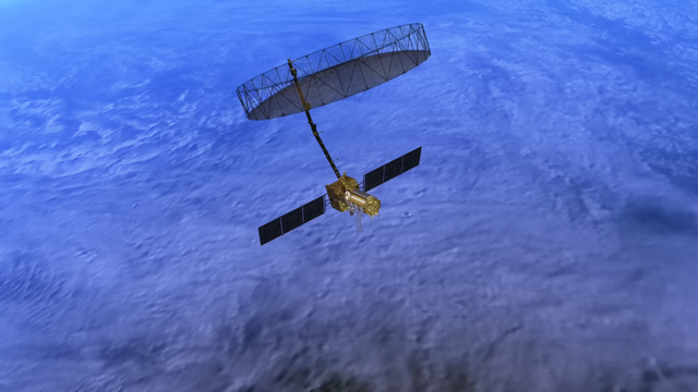
NISAR
Carrying an advanced radar system that will produce a dynamic, three-dimensional view of Earth in unprecedented detail, the NISAR (NASA-ISRO Synthetic Aperture Radar) satellite was launched from India on July 30, 2025. Jointly developed by NASA and the Indian Space Research Organisation (ISRO), the satellite can detect the movement of land and ice surfaces down to the centimeter. The mission will help protect communities by providing unique, actionable information to decision-makers in a diverse range of areas, including disaster response, infrastructure monitoring, and agricultural management.
https://science.nasa.gov/earth/
For more information on the NISAR mission, visit: https://nasa.gov/nisar.
Credit: NASA/JPL-Caltech; Additional media courtesy of USGS, ISRO, VDOS-URSC, and NPS, as marked; Earthquake imagery: NASA/JPL, N-SAIL, GeoGateway, SCEC, DOI 10.5967/5sq2-rs60, Google Earth; Licensed elements: volcano aerial footage (BlackBoxGuild/Shutterstock), flooded farmland (Vincent Film/MotionArray), helicopter over flooding (Retrofootage/Pond5)
#space #earth #astrophotography #photography #science #geology #nature #resources #climate #education
Alt...
A powerful new satellite will soon provide insights into natural hazards, ecosystems, agriculture, and other fields of study that affect communities around the globe. The NISAR mission is a collaboration between NASA and ISRO (Indian Space Research Organisation) and will use radar to track Earth’s changing surface in fine detail.
Short for NASA-ISRO Synthetic Aperture Radar, NISAR features an advanced radar system with two instruments: one from ISRO and one built at NASA’s Jet Propulsion Laboratory in Southern California. Using radar enables NISAR to map Earth’s land and ice surfaces day or night, regardless of whether skies are cloudy or clear.
NISAR will launch from ISRO’s Satish Dhawan Space Centre in Sriharikota, India. Launch is targeted for July 2025. Follow https://science.nasa.gov/blogs/nisar for the latest updates.
Credit: NASA/JPL-Caltech; Additional media courtesy of USGS, ISRO, VDOS-URSC, and NPS, as marked; Earthquake imagery: NASA/JPL, N-SAIL, GeoGateway, SCEC, DOI 10.5967/5sq2-rs60, Google Earth; Licensed elements: volcano aerial footage (BlackBoxGuild/Shutterstock), flooded farmland (Vincent Film/MotionArray), helicopter over flooding (Retrofootage/Pond5)
"All things share the same breath - the beast, the tree, the man. The air shares its spirit with all the life it supports."
-- Chief Seattle
Inside the Visualization: Aerosols
* Music Credit:
Universal Music Production: “Geology Spirals Instrumental” and “Collective Conscious Instrumental”
* Video Credits:
NASA's Goddard Space Flight Center
Emme Watkins (eMITS),
Kathleen Greer (GSFC AMA), Lesley Ott (HQ), Joseph V. Ardizzone (NASA/GSFC), Helen-Nicole Kostis (USRA)
Explanation:
NASA uses satellites, ground measurements, and powerful computer models to track tiny particles floating in our air called aerosols. These small particles can travel thousands of miles, affecting the air we breathe and how far we can see, even far from where they originated.
https://science.nasa.gov/earth/
#space #earth #astrophotography #photography #science #geology #nature #resources #climate #education
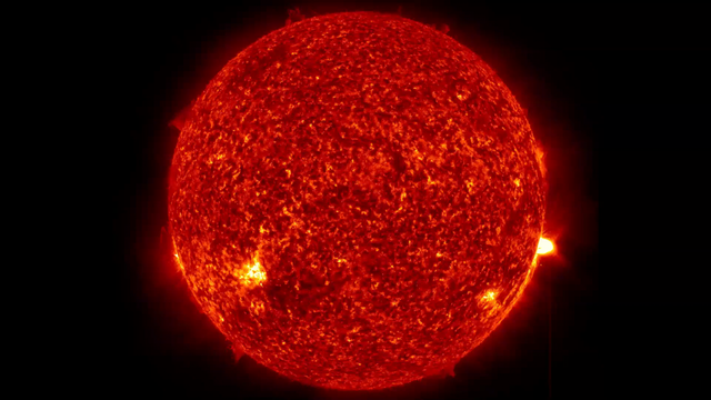
Sun news: Is the low sun activity the calm before the storm?
-- C. Alex Young
Today’s top story: Sun flare activity dropped back to low over the past day, with only faint C-class flares. But the past day’s flare count rose in contrast to recent days. We saw 15 flares in this period versus as few as six earlier in the week. Are we seeing the calm before the storm? We observed fiery activity on the northeast limb through repeated, slow, arching prominences. This action may rotate into Earth’s view in the coming days. Could it bring a surge in solar activity? Stay tuned.
https://earthsky.org/sun/sun-news-activity-solar-flare-cme-aurora-updates/
#space #sun #astrophotography #photography #science #astronomy #physics #nature #NASA #ESA
Alt...
Sun news for September 25-26, 2025. Prominence activity danced over northeast limb sending chromospheric plasma up and down in the solar corona.
Flare activity: Solar activity stayed at a low level, producing only C-class flares. The sun fired off 15 C-class flares during the period.
+ Strongest: C3.4 from AR4217 at 14:01 UTC on September 25.
* Other notable events: C2.4 (AR4226 at 19:21 UTC), C2.4 (from an incoming unnumbered region in the northeast at 6:28 UTC), and C2.3 (AR4220 at 18:53 UTC). The newcomer in the northeast led the count with seven C flares, closely followed by AR4217 with five.
Images via NOAA/GOES.

Alt...
As will other geostationary satellites, twice a year the spacecraft experiences an “eclipse” season where the Earth comes between the sun and the spacecraft for an approximately two week period.
Images via NOAA/GOES.
, C2.4 (from an incoming unnumbered region in the northeast at 6:28 UTC), and C2.3 (AR4220 at 18:53 UTC). The newcomer in the northeast led the count with seven C flares, closely followed by AR4217 with five.
Sunspot regions: Ten numbered active regions covered the Earth-facing solar disk.
The four regions — AR4230 (southeast), AR4217 (southwest), AR4226 (southeast), and AR4229 (southwest) — that showed gamma magnetic complexity yesterday, all simplified to beta configurations today.
The rest of the regions remained small, stable, or in slow decay.
A newcomer appeared in the southwest and was numbered AR4231.")
Alt...
This image shows sun activity – with the most active regions labeled – as of 4 UTC on September 27, 2025, as seen from Learmonth Solar Observatory in Australia.
* Original image, without labels, via NSO/GONG.
* Today’s sun is posted by Armando Caussade.
Q: Why are east and west on the sun reversed?
Flare activity: Solar activity stayed at a low level, producing only C-class flares. The sun fired off 15 C-class flares during the period.
Strongest: C3.4 from AR4217 at 14:01 UTC on September 25.
Other notable events: C2.4 (AR4226 at 19:21 UTC), C2.4 (from an incoming unnumbered region in the northeast at 6:28 UTC), and C2.3 (AR4220 at 18:53 UTC). The newcomer in the northeast led the count with seven C flares, closely followed by AR4217 with five.
Sunspot regions: Ten numbered active regions covered the Earth-facing solar disk.
The four regions — AR4230 (southeast), AR4217 (southwest), AR4226 (southeast), and AR4229 (southwest) — that showed gamma magnetic complexity yesterday, all simplified to beta configurations today.
The rest of the regions remained small, stable, or in slow decay.
A newcomer appeared in the southwest and was numbered AR4231.
 radio blackout observed over Africa. Total flare production also doubled compared to the previous day, with 14 flares blasted out during the past 24 hours.")
Alt...
An M1.6 solar flare from AR4224 captured by the SUVI instrument onboard the GOES spacecraft.
Images via NOAA.
Sun activity jumped up to moderate with the production of an M1.0 flare from active region AR4217 in the southwest. The blast occurred at 10:34 UTC on September 23. Along with the M flare, a type II radio emission was registered at 10:43 UTC along with an R1 (minor) radio blackout observed over Africa. Total flare production also doubled compared to the previous day, with 14 flares blasted out during the past 24 hours.
"Ahem, yes.. and no this is not First Mate Piggy's spacesuit and not Michael Jackson's costume for one of his most famous stage performances, even if this sculpture was called "Mooooonwalk", but read on for yourself..."
Suiting Up for the Moon
* Image Credit & Copyright: Robert Nemiroff (Michigan Tech. U.)
https://www.mtu.edu/physics/
https://www.mtu.edu/physics/department/faculty/nemiroff/
Explanation:
How will cows survive on the Moon? One of the most vexing questions asked about space, scientists have spent decades debating this key issue. Finally, after extensive computer modeling and over a dozen midnight milkings, engineers have designed, built, and now tested the new Lunar Grazing Module (LGM), a multi-purpose celestial bovine containment system. By now, many of you will not be surprised to be wished a Happy April Fool's Day from APOD. To the best of our knowledge, there are no current plans to launch cows into space. For one reason, cows tend to be large animals that don't launch easily or cheaply. As friendly as cows may be, head-to-head comparisons show that robotic rovers are usually more effective as scientific explorers. The featured image is of a thought-provoking work of art named "Mooooonwalk" which really is on display at a popular science museum.
+ Tech
https://www.ominous-valve.com/images/1954_c64.jpg
https://apod.nasa.gov/apod/ap140627.html
+ Science
https://science.nasa.gov/planetary-science/programs/mars-exploration/
+ Music
https://www.youtube.com/watch?v=lXKDu6cdXLI
+ Culture
https://en.wikipedia.org/wiki/April_Fools%27_Day
+ Nature
https://www.wikihow.com/Milk-a-Cow
https://apod.nasa.gov/apod/ap150401.html
#space_related #space #astrophotography #astroart #art #photography #science #nature #NASA #biology #culture #physics #Space_Culture_Club #tech

Explanation:
How will cows survive on the Moon? One of the most vexing questions asked about space, scientists have spent decades debating this key issue. Finally, after extensive computer modeling and over a dozen midnight milkings, engineers have designed, built, and now tested the new Lunar Grazing Module (LGM), a multi-purpose celestial bovine containment system. By now, many of you will not be surprised to be wished a Happy April Fool's Day from APOD. To the best of our knowledge, there are no current plans to launch cows into space. For one reason, cows tend to be large animals that don't launch easily or cheaply. As friendly as cows may be, head-to-head comparisons show that robotic rovers are usually more effective as scientific explorers. The featured image is of a thought-provoking work of art named \"Mooooonwalk\" which really is on display at a popular science museum.
Authors & editors: Robert Nemiroff (MTU) & Jerry Bonnell (UMCP)
NASA Official: Phillip Newman Specific rights apply.
NASA Web Privacy Policy and Important Notices
A service of: ASD at NASA / GSFC
& Michigan Tech. U.")
Alt...
Suiting Up for the Moon
* Image Credit & Copyright: Robert Nemiroff (Michigan Tech. U.)
Explanation:
How will cows survive on the Moon? One of the most vexing questions asked about space, scientists have spent decades debating this key issue. Finally, after extensive computer modeling and over a dozen midnight milkings, engineers have designed, built, and now tested the new Lunar Grazing Module (LGM), a multi-purpose celestial bovine containment system. By now, many of you will not be surprised to be wished a Happy April Fool's Day from APOD. To the best of our knowledge, there are no current plans to launch cows into space. For one reason, cows tend to be large animals that don't launch easily or cheaply. As friendly as cows may be, head-to-head comparisons show that robotic rovers are usually more effective as scientific explorers. The featured image is of a thought-provoking work of art named "Mooooonwalk" which really is on display at a popular science museum.
Authors & editors: Robert Nemiroff (MTU) & Jerry Bonnell (UMCP)
NASA Official: Phillip Newman Specific rights apply.
NASA Web Privacy Policy and Important Notices
A service of: ASD at NASA / GSFC
& Michigan Tech. U.
A sorrow shared is a sorrow halved, so they say ...
Shared joy is multiple joy, is another old wisdom ...
So we share the joy of you accompanying me to this party in the inner Mongolian steppe, where we are happy about little scattered light and some heavenly surprises, together with some joyful local astrophotographers:
"The Awe Perseid Meteors Party"
Feel free to make good whishes everytime you see one ...
Video Credit: Jeff Dai (TWAN); Music: Ibaotu catalog number 771024
https://spaceplace.nasa.gov/meteor-shower/en/
https://science.nasa.gov/solar-system/meteors-meteorites/facts/
https://apod.nasa.gov/apod/ap230809.html
https://apod.nasa.gov/apod/ap151118.html
https://www.youtube.com/watch?v=1NnMJUvU1L0
https://science.nasa.gov/solar-system/meteors-meteorites/perseids/
https://en.wikipedia.org/wiki/Geminids
#space_related #space #astrophotography #science #nature #culture #Space_Culture_Club #fun #wisdom
"Here, too, great parties have already been celebrated and this time with a very special fireworks display!"
2024 August 12
Perseid Meteors over Stonehenge
* Image Credit & Copyright: Josh Dury
https://www.instagram.com/josh_dury_photomedia/
Explanation:
What's happening in the sky above Stonehenge? A meteor shower: specifically, the Perseid meteor shower. A few nights ago, after the sky darkened, many images of meteors from this year's Perseids were captured separately and merged into a single frame. Although the meteors all traveled on straight paths, these paths appear slightly curved by the wide-angle lens of the capturing camera. The meteor streaks can all be traced back to a single point on the sky called the radiant, here just off the top of the frame in the constellation of Perseus. The same camera took a deep image of the background sky that brought up the central band of our Milky Way galaxy running nearly vertical through the image center. The featured image was taken from Wiltshire, England, being careful to include, at the bottom, the famous astronomical monument of Stonehenge. Although the Perseids peaked last night, some Perseid meteors should still be visible for a few more nights.
https://en.wikipedia.org/wiki/Perseids
https://apod.nasa.gov/apod/ap240811.html
https://en.wikipedia.org/wiki/Radiant_(meteor_shower)
https://en.wikipedia.org/wiki/Perseus_(constellation)
https://en.wikipedia.org/wiki/Stonehenge
https://apod.nasa.gov/apod/ap240812.html
#space_related #space #astrophotography #photography #science #nature #culture #Space_Culture_Club
 & Jerry Bonnell (UMCP)
NASA Official: Amber Straughn Specific rights apply.")
Alt...
2024 August 12
A night sky filled with stars and the band of our Milky Way galaxy is shown also filled with many streaks. The short streaks are all coordinated and together indicate a flow from the top of the image to the bottom. In the foreground at the bottom of the frame is Stonehenge.
Perseid Meteors over Stonehenge
* Image Credit & Copyright: Josh Dury
Explanation:
What's happening in the sky above Stonehenge? A meteor shower: specifically, the Perseid meteor shower. A few nights ago, after the sky darkened, many images of meteors from this year's Perseids were captured separately and merged into a single frame. Although the meteors all traveled on straight paths, these paths appear slightly curved by the wide-angle lens of the capturing camera. The meteor streaks can all be traced back to a single point on the sky called the radiant, here just off the top of the frame in the constellation of Perseus. The same camera took a deep image of the background sky that brought up the central band of our Milky Way galaxy running nearly vertical through the image center. The featured image was taken from Wiltshire, England, being careful to include, at the bottom, the famous astronomical monument of Stonehenge. Although the Perseids peaked last night, some Perseid meteors should still be visible for a few more nights.
Authors & editors: Robert Nemiroff (MTU) & Jerry Bonnell (UMCP)
NASA Official: Amber Straughn Specific rights apply.
This is the hottest party location in any case!
2013 February 26
Coronal Rain on the Sun
* Video Credit: Solar Dynamics Observatory, SVS, GSFC, NASA;
http://sdo.gsfc.nasa.gov/
https://svs.gsfc.nasa.gov/
http://www.nasa.gov/centers/goddard/home/index.html
http://www.nasa.gov/
* Music: Thunderbolt by Lars Leonhard
http://www.lars-leonhard.de/
Explanation:
Does it rain on the Sun? Yes, although what falls is not water but extremely hot plasma. An example occurred in mid-July 2012 after an eruption on the Sun that produced both a Coronal Mass Ejection and a moderate solar flare. What was more unusual, however, was what happened next. Plasma in the nearby solar corona was imaged cooling and falling back, a phenomenon known as coronal rain. Because they are electrically charged, electrons, protons, and ions in the rain were gracefully channeled along existing magnetic loops near the Sun's surface, making the scene appear as a surreal three-dimensional sourceless waterfall. The resulting surprisingly-serene spectacle is shown in ultraviolet light and highlights matter glowing at a temperature of about 50,000 Kelvin. Each second in the above time lapse video takes about 6 minutes in real time, so that the entire coronal rain sequence lasted about 10 hours.
https://en.wikipedia.org/wiki/Coronal_mass_ejection
https://apod.nasa.gov/apod/ap031029.html
https://apod.nasa.gov/apod/ap090726.html
https://en.wikipedia.org/wiki/Coronal_rain
https://apod.nasa.gov/apod/ap130226.html
#space_related #space #sun #astrophotography #Photography #science #physics #nature #Space_Culture_Club
Alt...
2013 February 26
Coronal Rain on the Sun
* Video Credit: Solar Dynamics Observatory, SVS, GSFC, NASA; Music: Thunderbolt by Lars Leonhard
Explanation:
Does it rain on the Sun? Yes, although what falls is not water but extremely hot plasma. An example occurred in mid-July 2012 after an eruption on the Sun that produced both a Coronal Mass Ejection and a moderate solar flare. What was more unusual, however, was what happened next. Plasma in the nearby solar corona was imaged cooling and falling back, a phenomenon known as coronal rain. Because they are electrically charged, electrons, protons, and ions in the rain were gracefully channeled along existing magnetic loops near the Sun's surface, making the scene appear as a surreal three-dimensional sourceless waterfall. The resulting surprisingly-serene spectacle is shown in ultraviolet light and highlights matter glowing at a temperature of about 50,000 Kelvin. Each second in the above time lapse video takes about 6 minutes in real time, so that the entire coronal rain sequence lasted about 10 hours.
Authors & editors: Robert Nemiroff (MTU) & Jerry Bonnell (UMCP)
NASA Official: Phillip Newman Specific rights apply.
NASA Web Privacy Policy and Important Notices
A service of: ASD at NASA / GSFC
& Michigan Tech. U.
2025 May 31
Afterimage Sunset
* Image Credit & Copyright: Marcella Giulia Pace
https://greenflash.photo/about-me/
Explanation:
On May 7, the Sun setting behind a church bell tower was captured in this filtered and manipulated digital skyscape from Ragusa, Sicily, planet Earth. In this version of the image the colors look bizarre. Still, an intriguing optical illusion known as an afterimage can help you experience the same scene with a more natural looking appearance. To try it, find the sunspots of active region AR4079 grouped near the bottom of the blue solar disk. Relax and stare at the dark sunspot group for about 30 seconds, then close your eyes or shift your gaze to a plain white surface. In a moment an afterimage of the sunset should faintly appear. But the afterimage sunset will have this image's complementary colors and a more normal yellow Sun against a familiar blue sky.
https://en.wikipedia.org/wiki/Afterimage
https://skyandtelescope.org/online-gallery/ar4079-giant-sunspot-with-eyes/
https://science.nasa.gov/sun/sunspots/
#space_related #space #sun #astrophotography #Photography #science #physics #nature #Space_Culture_Club
 & Jerry Bonnell (UMCP)
NASA Official: Amber Straughn Specific rights apply.
NASA Web Privacy Policy and Important Notices
A service of: ASD at NASA / GSFC,
NASA Science Activation
& Michigan Tech. U.")
Alt...
2025 May 31
Afterimage Sunset
* Image Credit & Copyright: Marcella Giulia Pace
Explanation:
On May 7, the Sun setting behind a church bell tower was captured in this filtered and manipulated digital skyscape from Ragusa, Sicily, planet Earth. In this version of the image the colors look bizarre. Still, an intriguing optical illusion known as an afterimage can help you experience the same scene with a more natural looking appearance. To try it, find the sunspots of active region AR4079 grouped near the bottom of the blue solar disk. Relax and stare at the dark sunspot group for about 30 seconds, then close your eyes or shift your gaze to a plain white surface. In a moment an afterimage of the sunset should faintly appear. But the afterimage sunset will have this image's complementary colors and a more normal yellow Sun against a familiar blue sky.
Authors & editors: Robert Nemiroff (MTU) & Jerry Bonnell (UMCP)
NASA Official: Amber Straughn Specific rights apply.
NASA Web Privacy Policy and Important Notices
A service of: ASD at NASA / GSFC,
NASA Science Activation
& Michigan Tech. U.
Electronic System is a project of the Belgian synthesizer legend Dan Lacksman.
He has performed under his own name, and in groups (most notably Telex). He was an early adopter of synth music, to the point where the first synthesizer he bought, just 3 years before the release of this song, was the first one in Belgium!
“Skylab” is a 14 minute long voyage through time and space. It’s definitely more of a lazy pleasure cruise than a hyperspace rush; you get plenty of time to appreciate the scenery.
And what scenery! The basis of the track is a sort of slow, jazzy strut, with a smooth bass part and a relaxed drum section. The dreamy electric piano lays down the primary texture for the song, which is embellished by confident Moog noodling.
The track was released in 1974 on the album Tchip.Tchip (Vol. 3), although a different version was released first in 1973 on a different version of the album called Electronic System 3, which is credited to “Dan Lacksman With Moog Synthesizer”.
Credit:
mymusic365.co.uk
#space_related #space #music #jazz #moog #skylab #grobi_muzak #Space_Culture_Club
Alt...
Electronic System is a project of the Belgian synthesizer legend Dan Lacksman.
He has performed under his own name, and in groups (most notably Telex). He was an early adopter of synth music, to the point where the first synthesizer he bought, just 3 years before the release of this song, was the first one in Belgium!
“Skylab” is a 14 minute long voyage through time and space. It’s definitely more of a lazy pleasure cruise than a hyperspace rush; you get plenty of time to appreciate the scenery.
And what scenery! The basis of the track is a sort of slow, jazzy strut, with a smooth bass part and a relaxed drum section. The dreamy electric piano lays down the primary texture for the song, which is embellished by confident Moog noodling.
The track was released in 1974 on the album Tchip.Tchip (Vol. 3), although a different version was released first in 1973 on a different version of the album called Electronic System 3, which is credited to “Dan Lacksman With Moog Synthesizer”.
And now to something completely mist irious:
2019 June 24
Anticrepuscular Rays Converge Opposite the Sun
* Image Credit & Copyright: Juraj Patekar
https://apod.nasa.gov/apod/ap190624.html
Explanation:
Is there ever anything interesting to see in the direction opposite the Sun? Sometimes there is. Notable items include your own shadow, a shadow of the Moon during a total solar eclipse, a full moon -- in eclipse if the alignment's good enough, a full earth, planets at opposition, glints from planets, the gegenschein from interplanetary dust, the center of a rainbow, hall-of-mountain fogbows, an airplane glory, and something yet again different if your timing, clouds and Sun position are just right. This different effect starts with clouds near the Sun that are causing common crepuscular rays to stream through. In the featured rare image taken from an airplane in mid-April, these beams were caught converging 180 degrees around, on the opposite side of the sky from the Sun, where they are called anticrepuscular rays. Therefore, it may look like something bright is shining at the antisolar point near the image center, but actually it is reverse-shining because, from your direction, light is streaming in, not out.
https://apod.nasa.gov/apod/ap190624.html
#space_related #space #sun #astrophotography #Photography #science #physics #nature #Space_Culture_Club
 & Jerry Bonnell (UMCP)
NASA Official: Phillip Newman Specific rights apply.
NASA Web Privacy Policy and Important Notices
A service of: ASD at NASA / GSFC
& Michigan Tech. U.")
Alt...
2019 June 24
Anticrepuscular Rays Converge Opposite the Sun
* Image Credit & Copyright: Juraj Patekar
Explanation:
Is there ever anything interesting to see in the direction opposite the Sun? Sometimes there is. Notable items include your own shadow, a shadow of the Moon during a total solar eclipse, a full moon -- in eclipse if the alignment's good enough, a full earth, planets at opposition, glints from planets, the gegenschein from interplanetary dust, the center of a rainbow, hall-of-mountain fogbows, an airplane glory, and something yet again different if your timing, clouds and Sun position are just right. This different effect starts with clouds near the Sun that are causing common crepuscular rays to stream through. In the featured rare image taken from an airplane in mid-April, these beams were caught converging 180 degrees around, on the opposite side of the sky from the Sun, where they are called anticrepuscular rays. Therefore, it may look like something bright is shining at the antisolar point near the image center, but actually it is reverse-shining because, from your direction, light is streaming in, not out.
Authors & editors: Robert Nemiroff (MTU) & Jerry Bonnell (UMCP)
NASA Official: Phillip Newman Specific rights apply.
NASA Web Privacy Policy and Important Notices
A service of: ASD at NASA / GSFC
& Michigan Tech. U.
2014 August 23
The Spectre of Veszprem
* Image Credit & Copyright: Tamas Ladanyi (TWAN)
https://www.asztrotajkep.hu/
Explanation:
The city of Veszprem, Hungary was only briefly haunted by this mysterious spectre. On the morning of August 11, its monstrous form hovered in the mist above municipal buildings near the town center. A clue to its true identity is offered by the photographer, though, who reports he took the picture from the top of a twenty story building with the rising Sun directly at his back. That special geometry suggests this is an example of an atmospheric phenomenon called the Glory or sometimes "the Spectre of the Brocken". Also seen from mountain tops and airplanes when looking opposite the Sun, the dramatic apparition is the observer's shadow on clouds or fog, the small droplets of water scattering light back towards the Sun through complex internal reflections. Careful night sky watchers can also encounter this spectre's analog in astronomy, a brightening of zodiacal light opposite the Sun known as the gegenschein.
https://apod.nasa.gov/apod/ap140823.html
#space_related #space #mist #astrophotography #Photography #science #physics #nature #Space_Culture_Club

Explanation:
The city of Veszprem, Hungary was only briefly haunted by this mysterious spectre. On the morning of August 11, its monstrous form hovered in the mist above municipal buildings near the town center. A clue to its true identity is offered by the photographer, though, who reports he took the picture from the top of a twenty story building with the rising Sun directly at his back. That special geometry suggests this is an example of an atmospheric phenomenon called the Glory or sometimes \"the Spectre of the Brocken\". Also seen from mountain tops and airplanes when looking opposite the Sun, the dramatic apparition is the observer's shadow on clouds or fog, the small droplets of water scattering light back towards the Sun through complex internal reflections. Careful night sky watchers can also encounter this spectre's analog in astronomy, a brightening of zodiacal light opposite the Sun known as the gegenschein.
Authors & editors: Robert Nemiroff (MTU) & Jerry Bonnell (UMCP)
NASA Official: Phillip Newman Specific rights apply.
NASA Web Privacy Policy and Important Notices
A service of: ASD at NASA / GSFC
& Michigan Tech. U.")
Alt...
2014 August 23
The Spectre of Veszprem
* Image Credit & Copyright: Tamas Ladanyi (TWAN)
Explanation:
The city of Veszprem, Hungary was only briefly haunted by this mysterious spectre. On the morning of August 11, its monstrous form hovered in the mist above municipal buildings near the town center. A clue to its true identity is offered by the photographer, though, who reports he took the picture from the top of a twenty story building with the rising Sun directly at his back. That special geometry suggests this is an example of an atmospheric phenomenon called the Glory or sometimes "the Spectre of the Brocken". Also seen from mountain tops and airplanes when looking opposite the Sun, the dramatic apparition is the observer's shadow on clouds or fog, the small droplets of water scattering light back towards the Sun through complex internal reflections. Careful night sky watchers can also encounter this spectre's analog in astronomy, a brightening of zodiacal light opposite the Sun known as the gegenschein.
Authors & editors: Robert Nemiroff (MTU) & Jerry Bonnell (UMCP)
NASA Official: Phillip Newman Specific rights apply.
NASA Web Privacy Policy and Important Notices
A service of: ASD at NASA / GSFC
& Michigan Tech. U.
Partager la « Nuit de la Vue Magnifique » avec la chèvre
2018 August 7
Eclipsed Moon and Mars over Mountains
* Image Credit & Copyright: Clèment Brustel
Explanation:
There is something unusual about this astronomically-oriented photograph. It's not obvious -- it was discovered only during post-processing. It is not the Moon, although capturing the Moon rising during a total lunar eclipse is quite an unusually interesting sight. It is not Mars, found to the lower right of the Moon, although Mars being captured near its brightest also makes for an unusually interesting sight. It is not the foreground mountains, although the French Alps do provide unusually spectacular perspectives on planet Earth.
It is the goat.
#space_related #space #moon #mars #mountain #astrophotography #Photography #nature #Space_Culture_Club
 & Jerry Bonnell (UMCP)
NASA Official: Phillip Newman Specific rights apply.
NASA Web Privacy Policy and Important Notices
A service of: ASD at NASA / GSFC
& Michigan Tech. U.")
Alt...
2018 August 7
Eclipsed Moon and Mars over Mountains
* Image Credit & Copyright: Clèment Brustel
Explanation:
There is something unusual about this astronomically-oriented photograph. It's not obvious -- it was discovered only during post-processing. It is not the Moon, although capturing the Moon rising during a total lunar eclipse is quite an unusually interesting sight. It is not Mars, found to the lower right of the Moon, although Mars being captured near its brightest also makes for an unusually interesting sight. It is not the foreground mountains, although the French Alps do provide unusually spectacular perspectives on planet Earth.
It is the goat.
Authors & editors: Robert Nemiroff (MTU) & Jerry Bonnell (UMCP)
NASA Official: Phillip Newman Specific rights apply.
NASA Web Privacy Policy and Important Notices
A service of: ASD at NASA / GSFC
& Michigan Tech. U.
2013 September 28
Equinox Earth
* Image Credit: Roscosmos / NTSOMZ / zelenyikot.livejournal.com
https://zelenyikot.livejournal.com/17213.html
* Courtesy: Igor Tirsky, Vitaliy Egorov
Explanation:
From a geostationary orbit 36,000 kilometers above the equator, Russian meteorological satellite Elektro-L takes high-resolution images of our fair planet every 30 minutes. But only twice a year, during an Equinox, can it capture an image like this one, showing an entire hemisphere bathed in sunlight. At an Equinox, the Earth's axis of rotation is not tilted toward or away from the Sun, so the solar illumination can extend to both the planet's poles. Of course, this Elektro-L picture was recorded on September 22nd, at the northern hemisphere's autumnal equinox. For a moment on that date, the Sun was behind the geostationary satellite and a telltale glint of reflected sunlight is seen crossing the equator, at the location on the planet with satellite and sun directly overhead
https://apod.nasa.gov/apod/ap130928.html
#space_related #space #earth #equinox #astrophotography #Photography #science #nature #Space_Culture_Club
.
Authors & editors: Robert Nemiroff (MTU) & Jerry Bonnell (UMCP)
NASA Official: Phillip Newman Specific rights apply.
NASA Web Privacy Policy and Important Notices
A service of: ASD at NASA / GSFC
& Michigan Tech. U.")
Alt...
2013 September 28
Equinox Earth
* Image Credit: Roscosmos / NTSOMZ / zelenyikot.livejournal.com
* Courtesy: Igor Tirsky, Vitaliy Egorov
Explanation:
From a geostationary orbit 36,000 kilometers above the equator, Russian meteorological satellite Elektro-L takes high-resolution images of our fair planet every 30 minutes. But only twice a year, during an Equinox, can it capture an image like this one, showing an entire hemisphere bathed in sunlight. At an Equinox, the Earth's axis of rotation is not tilted toward or away from the Sun, so the solar illumination can extend to both the planet's poles. Of course, this Elektro-L picture was recorded on September 22nd, at the northern hemisphere's autumnal equinox. For a moment on that date, the Sun was behind the geostationary satellite and a telltale glint of reflected sunlight is seen crossing the equator, at the location on the planet with satellite and sun directly overhead (5MB animated gif).
Authors & editors: Robert Nemiroff (MTU) & Jerry Bonnell (UMCP)
NASA Official: Phillip Newman Specific rights apply.
NASA Web Privacy Policy and Important Notices
A service of: ASD at NASA / GSFC
& Michigan Tech. U.
2014 January 14
The Gegenschein Over Chile
* Image Credit & Copyright: Yuri Beletsky (Las Campanas Observatory, Carnegie Institution)
Explanation:
Is the night sky darkest in the direction opposite the Sun? No. In fact, a rarely discernable faint glow known as the gegenschein (German for "counter glow") can be seen 180 degrees around from the Sun in an extremely dark sky. The gegenschein is sunlight back-scattered off small interplanetary dust particles. These dust particles are millimeter sized splinters from asteroids and orbit in the ecliptic plane of the planets. Pictured above from last year is one of the more spectacular pictures of the gegenschein yet taken. Here a deep exposure of an extremely dark sky over Las Campanas Observatory in Chile shows the gegenschein so clearly that even a surrounding glow is visible. Notable background objects include the Andromeda galaxy, the Pleiades star cluster, the California Nebula, the belt of Orion just below the Orion Nebula and inside Barnard's Loop, and bright stars Rigel and Betelgeuse. The gegenschein is distinguished from zodiacal light near the Sun by the high angle of reflection. During the day, a phenomenon similar to the gegenschein called the glory can be seen in reflecting air or clouds opposite the Sun from an airplane.
https://apod.nasa.gov/apod/ap140114.html
#space_related #space #gegenschein #astrophotography #Photography #mountains #science #physics #nature #Space_Culture_Club

Explanation:
Is the night sky darkest in the direction opposite the Sun? No. In fact, a rarely discernable faint glow known as the gegenschein (German for \"counter glow\") can be seen 180 degrees around from the Sun in an extremely dark sky. The gegenschein is sunlight back-scattered off small interplanetary dust particles. These dust particles are millimeter sized splinters from asteroids and orbit in the ecliptic plane of the planets. Pictured above from last year is one of the more spectacular pictures of the gegenschein yet taken. Here a deep exposure of an extremely dark sky over Las Campanas Observatory in Chile shows the gegenschein so clearly that even a surrounding glow is visible. Notable background objects include the Andromeda galaxy, the Pleiades star cluster, the California Nebula, the belt of Orion just below the Orion Nebula and inside Barnard's Loop, and bright stars Rigel and Betelgeuse. The gegenschein is distinguished from zodiacal light near the Sun by the high angle of reflection. During the day, a phenomenon similar to the gegenschein called the glory can be seen in reflecting air or clouds opposite the Sun from an airplane.
Authors & editors: Robert Nemiroff (MTU) & Jerry Bonnell (UMCP)
NASA Official: Phillip Newman Specific rights apply.")
Alt...
2014 January 14
The Gegenschein Over Chile
* Image Credit & Copyright: Yuri Beletsky (Las Campanas Observatory, Carnegie Institution)
Explanation:
Is the night sky darkest in the direction opposite the Sun? No. In fact, a rarely discernable faint glow known as the gegenschein (German for "counter glow") can be seen 180 degrees around from the Sun in an extremely dark sky. The gegenschein is sunlight back-scattered off small interplanetary dust particles. These dust particles are millimeter sized splinters from asteroids and orbit in the ecliptic plane of the planets. Pictured above from last year is one of the more spectacular pictures of the gegenschein yet taken. Here a deep exposure of an extremely dark sky over Las Campanas Observatory in Chile shows the gegenschein so clearly that even a surrounding glow is visible. Notable background objects include the Andromeda galaxy, the Pleiades star cluster, the California Nebula, the belt of Orion just below the Orion Nebula and inside Barnard's Loop, and bright stars Rigel and Betelgeuse. The gegenschein is distinguished from zodiacal light near the Sun by the high angle of reflection. During the day, a phenomenon similar to the gegenschein called the glory can be seen in reflecting air or clouds opposite the Sun from an airplane.
Authors & editors: Robert Nemiroff (MTU) & Jerry Bonnell (UMCP)
NASA Official: Phillip Newman Specific rights apply.
"The last and only time I saw a full circle rainbow was at an exhibition by Olafur Eliasson at the ARoS Museum Aarhus in Denmark. And in a completely unspectacular room with a black floor, walls and ceiling, to which a curved black garden hose peppered with fine holes was attached, from which a mist floated downwards. On two opposite walls hung a construction lamp, which shone light on the fog in the middle of the room at a 45° angle downwards. I walked through the fog with my eyes open and saw a complete rainbow ring that closed from the outside in, opened again and then disappeared."
https://olafureliasson.net/
https://www.aros.dk/en
2014 September 30
A Full Circle Rainbow over Australia
* Image Credit & Copyright: Colin Leonhardt (Birdseye View Photography)
https://www.birdseyeviewphotography.com.au/contact.shtml
Explanation:
Have you ever seen an entire rainbow? From the ground, typically, only the top portion of a rainbow is visible because directions toward the ground have fewer raindrops. From the air, though, the entire 360 degree circle of a rainbow is more commonly visible. Pictured here, a full circle rainbow was captured over Cottesloe Beach near Perth, Australia last year by a helicopter flying between a setting sun and a downpour. An observer-dependent phenomenon primarily caused by the internal reflection of sunlight by raindrops, the 84-degree diameter rainbow followed the helicopter, intact, for about 5 kilometers. As a bonus, a second rainbow that was more faint and color-reversed was visible outside the first.
https://apod.nasa.gov/apod/ap140930.html
#space_related #space #rainbow #astrophotography #Photography #science #nature #Space_Culture_Club

Explanation:
Have you ever seen an entire rainbow? From the ground, typically, only the top portion of a rainbow is visible because directions toward the ground have fewer raindrops. From the air, though, the entire 360 degree circle of a rainbow is more commonly visible. Pictured here, a full circle rainbow was captured over Cottesloe Beach near Perth, Australia last year by a helicopter flying between a setting sun and a downpour. An observer-dependent phenomenon primarily caused by the internal reflection of sunlight by raindrops, the 84-degree diameter rainbow followed the helicopter, intact, for about 5 kilometers. As a bonus, a second rainbow that was more faint and color-reversed was visible outside the first.
Authors & editors: Robert Nemiroff (MTU) & Jerry Bonnell (UMCP)
NASA Official: Phillip Newman Specific rights apply.
NASA Web Privacy Policy and Important Notices
A service of: ASD at NASA / GSFC
& Michigan Tech. U.")
Alt...
2014 September 30
A Full Circle Rainbow over Australia
* Image Credit & Copyright: Colin Leonhardt (Birdseye View Photography)
Explanation:
Have you ever seen an entire rainbow? From the ground, typically, only the top portion of a rainbow is visible because directions toward the ground have fewer raindrops. From the air, though, the entire 360 degree circle of a rainbow is more commonly visible. Pictured here, a full circle rainbow was captured over Cottesloe Beach near Perth, Australia last year by a helicopter flying between a setting sun and a downpour. An observer-dependent phenomenon primarily caused by the internal reflection of sunlight by raindrops, the 84-degree diameter rainbow followed the helicopter, intact, for about 5 kilometers. As a bonus, a second rainbow that was more faint and color-reversed was visible outside the first.
Authors & editors: Robert Nemiroff (MTU) & Jerry Bonnell (UMCP)
NASA Official: Phillip Newman Specific rights apply.
NASA Web Privacy Policy and Important Notices
A service of: ASD at NASA / GSFC
& Michigan Tech. U.
"Now it's time for me and I wish you a pleasant night and endless beautiful dreams. Thanks for the nice chat in between. Stay hopeful."
2025 March 30
A Partial Solar Eclipse over Iceland
* Image Credit & Copyright: Wioleta Gorecka
https://www.instagram.com/wiola.gorecka/
Explanation:
What if the Sun and Moon rose together? That happened yesterday over some northern parts of planet Earth as a partial solar eclipse occurred shortly after sunrise. Regions that experienced the Moon blocking part of the Sun included northeastern parts of North America and northwestern parts of Europe, Asia, and Africa. The featured image was captured yesterday over the Grábrók volcanic crater in Iceland where much of the Sun became momentarily hidden behind the Moon. The image was taken through a cloudy sky but so well planned that the photographer's friend appeared to be pulling the Sun out from behind the Moon. No part of the Earth experienced a total solar eclipse this time. In the distant past, some of humanity was so surprised when an eclipse occurred that ongoing battles suddenly stopped. Today, eclipses are not a surprise and are predicted with an accuracy of seconds.
https://science.nasa.gov/eclipses/future-eclipses/mar-29-2025-eclipse/
https://science.nasa.gov/eclipses/types/
https://en.wikipedia.org/wiki/Eclipse_of_Thales
https://apod.nasa.gov/apod/ap240310.html
https://www.timeanddate.com/eclipse/accuracy.html
https://en.wikipedia.org/wiki/Iceland
https://www.youtube.com/watch?v=ZxIPyR6-bko
https://science.nasa.gov/earth/facts/
https://apod.nasa.gov/apod/ap250330.html
#space #earth #sun #moon #eclipse #astrophotography #photography #science #nature #iceland #NASA
 & Jerry Bonnell (UMCP)
NASA Official: Amber Straughn Specific rights apply.
NASA Web Privacy, Accessibility, Notices;
A service of: ASD at NASA / GSFC,
NASA Science Activation
& Michigan Tech")
Alt...
2025 March 30
A a cloudy sky appears with an overall pink - red hue. The Sun appears partially eclipsed over a slanting hill. A person on the hill has their arms raised and appears to be holding up the partially eclipsed Sun. Please see the explanation for more detailed information.
A Partial Solar Eclipse over Iceland
Image Credit & Copyright: Wioleta Gorecka
Explanation:
What if the Sun and Moon rose together? That happened yesterday over some northern parts of planet Earth as a partial solar eclipse occurred shortly after sunrise. Regions that experienced the Moon blocking part of the Sun included northeastern parts of North America and northwestern parts of Europe, Asia, and Africa. The featured image was captured yesterday over the Grábrók volcanic crater in Iceland where much of the Sun became momentarily hidden behind the Moon. The image was taken through a cloudy sky but so well planned that the photographer's friend appeared to be pulling the Sun out from behind the Moon. No part of the Earth experienced a total solar eclipse this time. In the distant past, some of humanity was so surprised when an eclipse occurred that ongoing battles suddenly stopped. Today, eclipses are not a surprise and are predicted with an accuracy of seconds.
Authors & editors: Robert Nemiroff (MTU) & Jerry Bonnell (UMCP)
NASA Official: Amber Straughn Specific rights apply.
NASA Web Privacy, Accessibility, Notices;
A service of: ASD at NASA / GSFC,
NASA Science Activation
& Michigan Tech
2004 August 6
The Giant and the Glory
* Credit & Copyright: Franz Kerschbaum (Univ. Vienna)
Explanation:
On a flight from Vienna to Brussels, astronomer Franz Kerschbaum looked out the window and photographed this beautiful atmospheric phenomenon, the glory, shining in the direction directly opposite the Sun. Before airplanes, the glory, known to some as the heiligenschein or the Specter of the Brocken, was occasionally seen from mountaintops. There, when conditions were right, one could look away from the Sun and see what appeared to be the shadow of a giant surrounded by a bright halo. Of course, the giant turns out to be the observer, and in the modern version a silhouette of a plane frequently occupies the glory's center. The cause of the glory is relatively complex. Briefly, small droplets of water reflect, refract, and diffract sunlight backwards towards the Sun. The phenomenon has a counterpart in astronomy, where looking out from planet Earth in the direction opposite the Sun yields a bright spot called the gegenschein.
https://apod.nasa.gov/apod/ap040806.html
#space_related #space #rainbow #astrophotography #Photography #science #physics #nature #Space_Culture_Club

Explanation:
On a flight from Vienna to Brussels, astronomer Franz Kerschbaum looked out the window and photographed this beautiful atmospheric phenomenon, the glory, shining in the direction directly opposite the Sun. Before airplanes, the glory, known to some as the heiligenschein or the Specter of the Brocken, was occasionally seen from mountaintops. There, when conditions were right, one could look away from the Sun and see what appeared to be the shadow of a giant surrounded by a bright halo. Of course, the giant turns out to be the observer, and in the modern version a silhouette of a plane frequently occupies the glory's center. The cause of the glory is relatively complex. Briefly, small droplets of water reflect, refract, and diffract sunlight backwards towards the Sun. The phenomenon has a counterpart in astronomy, where looking out from planet Earth in the direction opposite the Sun yields a bright spot called the gegenschein.
Authors & editors: Robert Nemiroff (MTU) & Jerry Bonnell (USRA)
NASA Web Site Statements, Warnings, and Disclaimers
NASA Official: Jay Norris. Specific rights apply.
A service of: LHEA at NASA / GSFC
& Michigan Tech. U.")
Alt...
2004 August 6
The Giant and the Glory
* Credit & Copyright: Franz Kerschbaum (Univ. Vienna)
Explanation:
On a flight from Vienna to Brussels, astronomer Franz Kerschbaum looked out the window and photographed this beautiful atmospheric phenomenon, the glory, shining in the direction directly opposite the Sun. Before airplanes, the glory, known to some as the heiligenschein or the Specter of the Brocken, was occasionally seen from mountaintops. There, when conditions were right, one could look away from the Sun and see what appeared to be the shadow of a giant surrounded by a bright halo. Of course, the giant turns out to be the observer, and in the modern version a silhouette of a plane frequently occupies the glory's center. The cause of the glory is relatively complex. Briefly, small droplets of water reflect, refract, and diffract sunlight backwards towards the Sun. The phenomenon has a counterpart in astronomy, where looking out from planet Earth in the direction opposite the Sun yields a bright spot called the gegenschein.
Authors & editors: Robert Nemiroff (MTU) & Jerry Bonnell (USRA)
NASA Web Site Statements, Warnings, and Disclaimers
NASA Official: Jay Norris. Specific rights apply.
A service of: LHEA at NASA / GSFC
& Michigan Tech. U.
2012 March 31
Paris by Night
* Image Credit & Copyright: Serge Brunier (TWAN)
Explanation:
Do you recognize the lights of Paris in this picture? In the cityscape taken on March 25 from the top of the 210 meter tall Montparnasse skyscraper, many will spot the looming Eiffel Tower, or the large domed structure of Les Invalides (right), or the colorfully lit elevated Metro train line gently curving toward picture center. You can even pick out the Arc de Triomphe close to the horizon on the right. But regardless of your location, the celestial lights near the western horizon should look very familiar. The lovely triple conjuntion of brilliant Venus (top), Jupiter, and a young crescent Moon was visible in evening skies around planet Earth.
https://apod.nasa.gov/apod/ap120331.html
#space_related #space #earth #paris #astrophotography #photography #nature #science #Space_Culture_Club

Explanation:
Do you recognize the lights of Paris in this picture? In the cityscape taken on March 25 from the top of the 210 meter tall Montparnasse skyscraper, many will spot the looming Eiffel Tower, or the large domed structure of Les Invalides (right), or the colorfully lit elevated Metro train line gently curving toward picture center. You can even pick out the Arc de Triomphe close to the horizon on the right. But regardless of your location, the celestial lights near the western horizon should look very familiar. The lovely triple conjuntion of brilliant Venus (top), Jupiter, and a young crescent Moon was visible in evening skies around planet Earth.
Authors & editors: Robert Nemiroff (MTU) & Jerry Bonnell (UMCP)
NASA Official: Phillip Newman Specific rights apply.
NASA Web Privacy Policy and Important Notices
A service of: ASD at NASA / GSFC
& Michigan Tech. U.")
Alt...
2012 March 31
Paris by Night
* Image Credit & Copyright: Serge Brunier (TWAN)
Explanation:
Do you recognize the lights of Paris in this picture? In the cityscape taken on March 25 from the top of the 210 meter tall Montparnasse skyscraper, many will spot the looming Eiffel Tower, or the large domed structure of Les Invalides (right), or the colorfully lit elevated Metro train line gently curving toward picture center. You can even pick out the Arc de Triomphe close to the horizon on the right. But regardless of your location, the celestial lights near the western horizon should look very familiar. The lovely triple conjuntion of brilliant Venus (top), Jupiter, and a young crescent Moon was visible in evening skies around planet Earth.
Authors & editors: Robert Nemiroff (MTU) & Jerry Bonnell (UMCP)
NASA Official: Phillip Newman Specific rights apply.
NASA Web Privacy Policy and Important Notices
A service of: ASD at NASA / GSFC
& Michigan Tech. U.
2009 October 23
A Galilean Night
* Credit & Copyright: Jens Hackmann
Explanation:
Driving along on a summer evening, near the small town of Weikersheim in southern Germany, photographer Jens Hackmann had to stop. He couldn't resist pointing his camera and telephoto lens at this lovely conjunction of a Full Moon and planet Jupiter looming near the steeple of a local church. Of course, 400 years ago, Galileo couldn't resist pointing his newly constructed telescope at these celestial beacons either. When he did, he found craters and mountains on the not-so-smooth lunar surface and discovered the large moons of Jupiter now known as the Galilean Moons. Jupiter's Galilean moons are just visible in this photo as tiny pinpricks of light very near the bright planet.
https://apod.nasa.gov/apod/ap091023.html
#space_related #space #moon #astrophotography #Photography #science #nature #Space_Culture_Club
 & Jerry Bonnell (UMCP)
NASA Official: Phillip Newman Specific rights apply.
NASA Web Privacy Policy and Important Notices
A service of: ASD at NASA / GSFC
& Michigan Tech. U.")
Alt...
2009 October 23
A Galilean Night
* Credit & Copyright: Jens Hackmann
Explanation:
Driving along on a summer evening, near the small town of Weikersheim in southern Germany, photographer Jens Hackmann had to stop. He couldn't resist pointing his camera and telephoto lens at this lovely conjunction of a Full Moon and planet Jupiter looming near the steeple of a local church. Of course, 400 years ago, Galileo couldn't resist pointing his newly constructed telescope at these celestial beacons either. When he did, he found craters and mountains on the not-so-smooth lunar surface and discovered the large moons of Jupiter now known as the Galilean Moons. Jupiter's Galilean moons are just visible in this photo as tiny pinpricks of light very near the bright planet.
Authors & editors: Robert Nemiroff (MTU) & Jerry Bonnell (UMCP)
NASA Official: Phillip Newman Specific rights apply.
NASA Web Privacy Policy and Important Notices
A service of: ASD at NASA / GSFC
& Michigan Tech. U.
2000 November 18
Jupiter And Family
* Credit & Copyright: Galileo Project, Voyager Project, JPL, NASA
https://www.jpl.nasa.gov/search/?query=Galileo
Explanation:
This composite image features classic portraits of members of one of the Solar System's most prominent families - Jupiter and its four large "Galilean" moons. Starting from the top the moons are Io, Europa, Ganymede, and Callisto. The top-to-bottom order is also the order of increasing distance from Jupiter. These are big moons indeed which attend the largest planet. The smallest of the lot, Europa, is the size of Earth's moon while Ganymede is the largest moon in the Solar System. In fact, Ganymede with a diameter of 3,100 miles, is larger than the planets Mercury and Pluto. The swirling Great Red Spot appears at the edge of Jupiter. A hurricane-like storm system that has persisted for over 300 years, two to three earths could fit inside it. Battered Callisto's image was recorded during the 1979 flyby of Voyager. The other portraits were taken by the Galileo spacecraft which began exploring the Jovian system in 1995.
https://apod.nasa.gov/apod/ap001118.html
#space_related #space #galileo #astrophotography #Photography #science #nature #Space_Culture_Club
 & Jerry Bonnell (USRA)
NASA Technical Rep.: Jay Norris. Specific rights apply.
A service of: LHEA at NASA/GSFC
& Michigan Tech. U.")
Alt...
2000 November 18
Jupiter And Family
* Credit & Copyright: Galileo Project, Voyager Project, JPL, NASA
Explanation:
This composite image features classic portraits of members of one of the Solar System's most prominent families - Jupiter and its four large "Galilean" moons. Starting from the top the moons are Io, Europa, Ganymede, and Callisto. The top-to-bottom order is also the order of increasing distance from Jupiter. These are big moons indeed which attend the largest planet. The smallest of the lot, Europa, is the size of Earth's moon while Ganymede is the largest moon in the Solar System. In fact, Ganymede with a diameter of 3,100 miles, is larger than the planets Mercury and Pluto. The swirling Great Red Spot appears at the edge of Jupiter. A hurricane-like storm system that has persisted for over 300 years, two to three earths could fit inside it. Battered Callisto's image was recorded during the 1979 flyby of Voyager. The other portraits were taken by the Galileo spacecraft which began exploring the Jovian system in 1995.
Authors & editors: Robert Nemiroff (MTU) & Jerry Bonnell (USRA)
NASA Technical Rep.: Jay Norris. Specific rights apply.
A service of: LHEA at NASA/GSFC
& Michigan Tech. U.
2011 November 25
A Glimpse of CLIMSO
* Image Credit & Copyright: Alain Sallez (picdumidi.org)
Explanation:
A tantalizing glimpse inside this dome was captured after sunset at the mountain top Pic Du Midi Observatory in the French Pyrenees. But while most are just beginning their work at sunset, this observatory's day was done. The instrument looming within is CLIMSO (for Christian Latouche IMageur Solaire), dedicated to exploring dynamic phenomena across the surface and atmosphere of the Sun. To image the solar atmosphere or corona, CLIMSO uses coronagraphs. Developed by French astronomer Bernard Lyot in the 1930s, coronagraphs block light from the center of the telescope beam to create an artificial solar eclipse and allow a continuous view of the solar corona. In this surreal twilight scene above a sea of clouds, the dome's interior was revealed by the single, long exposure as the open slit rotated across the field of view. https://eclipse.gsfc.nasa.gov/OH/OH2011.html#SE2011Nov25P
https://www.swsc-journal.org/articles/swsc/pdf/2020/01/swsc200034.pdf
https://www.aanda.org/articles/aa/pdf/2019/11/aa32504-17.pdf
https://apod.nasa.gov/apod/ap111125.html
#space_related #space #observatory #astrophotography #Photography #science #nature #Space_Culture_Club

Explanation:
A tantalizing glimpse inside this dome was captured after sunset at the mountain top Pic Du Midi Observatory in the French Pyrenees. But while most are just beginning their work at sunset, this observatory's day was done. The instrument looming within is CLIMSO (for Christian Latouche IMageur Solaire), dedicated to exploring dynamic phenomena across the surface and atmosphere of the Sun. To image the solar atmosphere or corona, CLIMSO uses coronagraphs. Developed by French astronomer Bernard Lyot in the 1930s, coronagraphs block light from the center of the telescope beam to create an artificial solar eclipse and allow a continuous view of the solar corona. In this surreal twilight scene above a sea of clouds, the dome's interior was revealed by the single, long exposure as the open slit rotated across the field of view.
Authors & editors: Robert Nemiroff (MTU) & Jerry Bonnell (UMCP)
NASA Official: Phillip Newman Specific rights apply.
NASA Web Privacy Policy and Important Notices
A service of: ASD at NASA / GSFC
& Michigan Tech. U.")
Alt...
2011 November 25
A Glimpse of CLIMSO
* Image Credit & Copyright: Alain Sallez (picdumidi.org)
Explanation:
A tantalizing glimpse inside this dome was captured after sunset at the mountain top Pic Du Midi Observatory in the French Pyrenees. But while most are just beginning their work at sunset, this observatory's day was done. The instrument looming within is CLIMSO (for Christian Latouche IMageur Solaire), dedicated to exploring dynamic phenomena across the surface and atmosphere of the Sun. To image the solar atmosphere or corona, CLIMSO uses coronagraphs. Developed by French astronomer Bernard Lyot in the 1930s, coronagraphs block light from the center of the telescope beam to create an artificial solar eclipse and allow a continuous view of the solar corona. In this surreal twilight scene above a sea of clouds, the dome's interior was revealed by the single, long exposure as the open slit rotated across the field of view.
Authors & editors: Robert Nemiroff (MTU) & Jerry Bonnell (UMCP)
NASA Official: Phillip Newman Specific rights apply.
NASA Web Privacy Policy and Important Notices
A service of: ASD at NASA / GSFC
& Michigan Tech. U.
2025 June 20
Major Lunar Standstill 2024-2025
* Image Credit & Copyright: Luca Vanzella, Alister Ling
https://www.flickr.com/people/53851348@N05/
https://www.flickr.com/people/99775232@N07/
Explanation:
Edmonton, Alberta, Canada, planet Earth lies on the horizon. in this stack of panoramic composite images. In a monthly time series arranged vertically top to bottom the ambitious photographic project follows the annual north-south swing of sunrise points, from June solstice to December solstice and back again. It also follows the corresponding, but definitely harder to track, Full Moon rise. Of course, the north-south swing of moonrise runs opposite sunrise along the horizon. But these rising Full Moons also span a wider range on the horizon than the sunrises. That's because the well-planned project (as shown in this video !>>) covers the period June 2024 to June 2025, centered on a major lunar standstill. Major lunar standstills represent extremes in the north-south range of moonrise driven by the 18.6 year precession period of the lunar orbit.
https://en.wikipedia.org/wiki/Lunar_standstill
https://griffithobservatory.org/extreme-moon-the-major-lunar-standstills-of-2024-2025/
https://earthsky.org/tonight/june-full-moon/
!>> https://www.youtube.com/watch?v=u1tkLRdaFNk
https://earthsky.org/astronomy-essentials/everything-you-need-to-know-june-solstice/
https://apod.nasa.gov/apod/ap160922.html
https://apod.nasa.gov/apod/ap160922.html
#space #space_related #earth #moon #sun #astronomy #astrophotography #photography #science #nature #Space_Culture_Club
 covers the period June 2024 to June 2025, centered on a major lunar standstill. Major lunar standstills represent extremes in the north-south range of moonrise driven by the 18.6 year precession period of the lunar orbit.
Authors & editors: Robert Nemiroff (MTU) & Jerry Bonnell (UMCP)
NASA Official: Amber Straughn Specific rights apply.
NASA Web Privacy, Accessibility, Notices;
A service of: ASD at NASA / GSFC,
NASA Science Activation
& Michigan Tech. U.")
Alt...
2025 June 20
Major Lunar Standstill 2024-2025
* Image Credit & Copyright: Luca Vanzella, Alister Ling
Explanation:
Edmonton, Alberta, Canada, planet Earth lies on the horizon. in this stack of panoramic composite images. In a monthly time series arranged vertically top to bottom the ambitious photographic project follows the annual north-south swing of sunrise points, from June solstice to December solstice and back again. It also follows the corresponding, but definitely harder to track, Full Moon rise. Of course, the north-south swing of moonrise runs opposite sunrise along the horizon. But these rising Full Moons also span a wider range on the horizon than the sunrises. That's because the well-planned project (as shown in this video) covers the period June 2024 to June 2025, centered on a major lunar standstill. Major lunar standstills represent extremes in the north-south range of moonrise driven by the 18.6 year precession period of the lunar orbit.
Authors & editors: Robert Nemiroff (MTU) & Jerry Bonnell (UMCP)
NASA Official: Amber Straughn Specific rights apply.
NASA Web Privacy, Accessibility, Notices;
A service of: ASD at NASA / GSFC,
NASA Science Activation
& Michigan Tech. U.
The Major Lunar Standstill - a real, visual representation
by
Luca Vanzella: https://vanzella.com/luca-vanzellas-astronomy-page/
Alister Ling: https://www.astronomy.com/author/alister-ling/
This video shows thirteen moonrise and thirteen sunrise images from June 2024 to June 2025, to visually depict the change in moonrise/sunrise position over a year and to illustrate that the greatest northern and southern positions of the Moon extend beyond those of the Sun during a Major Lunar Standstill (https://griffithobservatory.org/extre....
Short Story
Celebrating the northeastern and southeastern extremes of sunrise points (solstices) are familiar experiences to all casual skywatchers but the moonrise extremes (lunistices) mostly go unnoticed except to attentive observers. As the Moon’s orbit slowly regresses in an 18.6 year cycle, the span of moonrise points varies between two extremes: the minor and major lunar standstills. In a major lunar standstill, the extreme moonrise points are several degrees farther north and south than the sunrise ones. Inspired by an earlier project ( • A Year of Sunrises ) of creating a time slice of sunrises, we wanted to capture these events photographically in a manner both educationally and visually compelling.
Technically the Major Lunar Standstill is a point in time on the dates of the extreme north and south lunar declinations, both occurring in March 2025, but similar to solstices, it is best appreciated in the context of a period of observation. Any consistent phase would reveal the pattern, but a full Moon is the most eye-catching and stands out best in very wide images.
The period from the June 2024 solstice to thttps://defcon.social/keyboard-shortcutshe June 2025 solstice nicely surrounds the standstill, so we shot thirteen full moonrises and thirteen sunrises to represent the Major Lunar Standstill with a vertical time slice composite image and this video.
#space #space_related #earth #moon #sun #astronomy #astrophotography #photography #science #nature #Space_Culture_Club
Alt...
Camera: T3i / Canon 60D Lens: Canon EF-S 10-18mm @ 10mm
Settings: ISO 200, Daylight WB, f/4.5
Sunrises: 3x1EV bracket, e.g.: 1/125, 1/250, 1/500 sec
Moonrises: 6x2EV bracket, e.g.: 2, 1/2, 1/8, 1/30, 1/125, 1/500 sec
Event Data
Here's the essential data from the 26 events. Each sunrise was planned to capture the Sun about 0.5° above the horizon, while each moonrise was planned to capture the Moon about 2.5° above the horizon.
Target Moonrise Moon D | Sunrise Sun D
Date Actual Az Az | Actual Az Az
2024 06 21 2024 06 21 151.2 0.0 | 2022 06 19 46.6 -0.1
2024 07 21 2024 07 21 134.5 0.0 | 2022 07 21 52.7 0.2
2024 08 19 2022 08 12 118.5 1.1 | 2022 08 19 67.2 0.2
2024 09 17 2022 09 10 101.8 2.6 | 2022 09 17 85.3 0.4
2024 10 17 2024 10 17 69.5 0.0 | 2022 10 17 104.8 0.3
2024 11 15 2023 11 26 54.8 0.1 | 2022 11 14 120.6 0.8
2024 12 15 2023 11 28 44.9 1.4 | 2022 12 13 130.0 0.3
2025 01 13 2025 01 13 49.1 0.0 | 2022 01 16 125.4 1.0
2025 02 12 2025 02 17 71.1 0.0 | 2022 02 11 112.6 -0.7
2025 03 14 2023 04 05 101.6 3.8 | 2022 03 16 91.6 1.2
2025 04 12 2025 04 12 115.7 1.0 | 2022 04 11 74.6 -0.8
2025 05 12 2022 07 13 142.7 3.0 | 2022 05 12 57.0 -0.1
2025 06 11 2024 05 25 151.0 0.0 | 2022 06 12 47.1 0.1
June solstice in 2025: All you need to know
By Editors of EarthSky
June 15, 2025
A solstice lasts only a moment, when the sun is at its farthest north in our sky for an entire year. In 2025, the solstice moment will fall at 2:42 UTC on June 21. That’s 9:42 p.m. on June 20 for us in central North America. Yet many will celebrate this solstice for a whole day. What makes this day so special? And what is a solstice? Join EarthSky’s Deborah Byrd with a preview of the June solstice 2025. Watch in the player below.
https://earthsky.org/astronomy-essentials/everything-you-need-to-know-june-solstice/
#space_related #space #earth #sun #solstice #astronomy #science #nature #Space_Culture_Club
Alt...
June solstice in 2025: All you need to know
By Editors of EarthSky
June 15, 2025
A solstice lasts only a moment, when the sun is at its farthest north in our sky for an entire year. In 2025, the solstice moment will fall at 2:42 UTC on June 21. That’s 9:42 p.m. on June 20 for us in central North America. Yet many will celebrate this solstice for a whole day. What makes this day so special? And what is a solstice? Join EarthSky’s Deborah Byrd with a preview of the June solstice 2025. Watch in the player below.
2025 July 18
ISS Meets Saturn
* Image Credit & Copyright: A.J. Smadi
https://www.instagram.com/aj.smadi/
Explanation:
This month, bright planet Saturn rises in evening skies, its rings oriented nearly edge-on when viewed from planet Earth. And in the early morning hours on July 6, it posed very briefly with the International Space Station when viewed from a location in Federal Way, Washington, USA. This well-planned image, a stack of video frames, captures their momentary conjunction in the same telescopic field of view. With the ISS in low Earth orbit, space station and gas giant planet were separated by almost 1.4 billion kilometers. Their apparent sizes are comparable but the ISS was much brighter than Saturn and the ringed planet's brightness has been increased for visibility in the stacked image. Precise timing and an exact location were needed to capture the ISS/Saturn conjunction.
https://www.nasa.gov/spot-the-station/
https://www.nasa.gov/missions/station/iss-research/observing-our-planet-from-low-earth-orbit/
https://apod.nasa.gov/apod/image/2507/ISSMeetsSaturn1_1024.jpg
https://apod.nasa.gov/apod/ap250718.html
#Space_Culture_Club #space #iss #astrophotography #photography #science #astronomy #nature #NASA
 & Jerry Bonnell (UMCP)
NASA Official: Amber Straughn Specific rights apply.
NASA Web Privacy, Accessibility, Notices;
A service of: ASD at NASA / GSFC,
NASA Science Activation
& Michigan Tech. U.")
Alt...
Image with annotations
2025 July 18
ISS Meets Saturn
* Image Credit & Copyright: A.J. Smadi
Explanation:
This month, bright planet Saturn rises in evening skies, its rings oriented nearly edge-on when viewed from planet Earth. And in the early morning hours on July 6, it posed very briefly with the International Space Station when viewed from a location in Federal Way, Washington, USA. This well-planned image, a stack of video frames, captures their momentary conjunction in the same telescopic field of view. With the ISS in low Earth orbit, space station and gas giant planet were separated by almost 1.4 billion kilometers. Their apparent sizes are comparable but the ISS was much brighter than Saturn and the ringed planet's brightness has been increased for visibility in the stacked image. Precise timing and an exact location were needed to capture the ISS/Saturn conjunction.
Authors & editors: Robert Nemiroff (MTU) & Jerry Bonnell (UMCP)
NASA Official: Amber Straughn Specific rights apply.
NASA Web Privacy, Accessibility, Notices;
A service of: ASD at NASA / GSFC,
NASA Science Activation
& Michigan Tech. U.

Alt...
Edited Image of ISS in front of Saturn

Alt...
Unedited Image of ISS in front of Saturn.
"How about a little manual work for a change to really come down from the stress of the day? Let's be inspired by the quilting of Judy W. Ross and make ourselves comfortable with a cup of tea."
2004 November 25
What the Hubble Saw
* Credit & Copyright: Judy W. Ross, Point Roberts, WA
Explanation:
In this striking 41 inch by 38 inch quilt, astronomy enthusiast Judy Ross has interpreted some of the Hubble Space Telescope's best galactic and extragalactic vistas. Featured in past APODs, clockwise from the lower right are; the Red Rectangle Nebula, NGC 2392, the Sleeping Beauty Galaxy, V838 Monocerotis - the Milky Way's most mysterious star, and supernova remnant N49 - the cosmic debris from an exploded star. Of course, quilts have been used historically to represent astronomical concepts. And while inspired by the images of the cosmos that she incorporates into her quilts, Ross reports that she is still a little daunted by the intricacies of the Cat's Eye Nebula revealed by the Hubble's sharp vision.
https://quiltindex.org/
https://apod.nasa.gov/apod/ap041125.html
#space #NASA #astrophotography #photography #art #astroart #quilting #quilt #craft #space_related #Space_Culture_Club
 & Jerry Bonnell (USRA)
NASA Web Site Statements, Warnings, and Disclaimers
NASA Official: Jay Norris. Specific rights apply.
A service of: LHEA at NASA / GSFC
& Michigan Tech. U.")
Alt...
2004 November 25
What the Hubble Saw
* Credit & Copyright: Judy W. Ross, Point Roberts, WA
Explanation:
In this striking 41 inch by 38 inch quilt, astronomy enthusiast Judy Ross has interpreted some of the Hubble Space Telescope's best galactic and extragalactic vistas. Featured in past APODs, clockwise from the lower right are; the Red Rectangle Nebula, NGC 2392, the Sleeping Beauty Galaxy, V838 Monocerotis - the Milky Way's most mysterious star, and supernova remnant N49 - the cosmic debris from an exploded star. Of course, quilts have been used historically to represent astronomical concepts. And while inspired by the images of the cosmos that she incorporates into her quilts, Ross reports that she is still a little daunted by the intricacies of the Cat's Eye Nebula revealed by the Hubble's sharp vision.
Authors & editors: Robert Nemiroff (MTU) & Jerry Bonnell (USRA)
NASA Web Site Statements, Warnings, and Disclaimers
NASA Official: Jay Norris. Specific rights apply.
A service of: LHEA at NASA / GSFC
& Michigan Tech. U.
"After a somewhat clumsy and obviously drunk young man has just vomited on the carpet in the entrance area, in order to enable him to recover quickly, sufficient fresh air was provided and we now make a pleasant fire in the fireplace."
2021 March 3
Stars over an Erupting Volcano
* Image Credit & Copyright: Giuseppe Vella
https://www.instagram.com/Peppe.vella_photography/
Explanation:
Mt. Etna has been erupting for hundreds of thousands of years. Located in Sicily, Italy, the volcano produces lava fountains over one kilometer high. Mt. Etna is not only one of the most active volcanoes on Earth, it is one of the largest, measuring over 50 kilometers at its base and rising nearly 3 kilometers high. Pictured erupting last month, a lava plume shoots upwards, while hot lava flows down the volcano's exterior. Likely satellite trails appear above, while ancient stars dot the sky far in the distance. This volcanic eruption was so strong that nearby airports were closed to keep planes from flying through the dangerous plume. The image foreground and background were captured consecutively by the same camera and from the same location.
https://apod.nasa.gov/apod/ap210303.html
#space #earth #volcano #NASA #photography #nature #space_related #Space_Culture_Club
 & Jerry Bonnell (UMCP)
NASA Official: Phillip Newman Specific rights apply.
NASA Web Privacy Policy and Important Notices
A service of: ASD at NASA / GSFC
& Michigan Tech. U.")
Alt...
2021 March 3
Stars over an Erupting Volcano
* Image Credit & Copyright: Giuseppe Vella
Explanation:
Mt. Etna has been erupting for hundreds of thousands of years. Located in Sicily, Italy, the volcano produces lava fountains over one kilometer high. Mt. Etna is not only one of the most active volcanoes on Earth, it is one of the largest, measuring over 50 kilometers at its base and rising nearly 3 kilometers high. Pictured erupting last month, a lava plume shoots upwards, while hot lava flows down the volcano's exterior. Likely satellite trails appear above, while ancient stars dot the sky far in the distance. This volcanic eruption was so strong that nearby airports were closed to keep planes from flying through the dangerous plume. The image foreground and background were captured consecutively by the same camera and from the same location.
Authors & editors: Robert Nemiroff (MTU) & Jerry Bonnell (UMCP)
NASA Official: Phillip Newman Specific rights apply.
NASA Web Privacy Policy and Important Notices
A service of: ASD at NASA / GSFC
& Michigan Tech. U.
"Before going to bed, we dedicate ourselves once again to the works of Judy W. Ross. Because in an anniversary year, all those involved and supporters should receive the recognition they deserve."
2003 October 17
Astronomy Quilt of the Week
* Credit & Copyright: Judy W. Ross, Point Roberts, WA
Explanation:
Demonstrating her mastery of a traditional astronomical imaging technique quilter and astronomy enthusiast Judy Ross has produced this spectacular composition of "Astronomy Quilt Piece of the Week". Her year-long effort resulted in an arrangement for a six by seven foot quilt consisting of 52 individual pieces (11 inches by 8 inches), one for each week, which she reports were inspired by her steady diet of APOD's daily offerings. Some of the pieces are based on actual pictures, such as the Hubble Space Telescope's view of planet forming AB Aurigae or Bill Keel's image of the nearby Pinwheel Galaxy. Others, with titles like the Blue Carpet Nebula and Duck Contemplates Black Hole, are from her own creative imaginings.
#space #NASA #astrophotography #apod #aniversary #photography #art #astroart #quilting #quilt #craft #space_related #Space_Culture_Club
, one for each week, which she reports were inspired by her steady diet of APOD's daily offerings. Some of the pieces are based on actual pictures, such as the Hubble Space Telescope's view of planet forming AB Aurigae or Bill Keel's image of the nearby Pinwheel Galaxy. Others, with titles like the Blue Carpet Nebula and Duck Contemplates Black Hole, are from her own creative imaginings.
Authors & editors: Robert Nemiroff (MTU) & Jerry Bonnell (USRA)
NASA Web Site Statements, Warnings, and Disclaimers
NASA Official: Jay Norris. Specific rights apply.
A service of: LHEA at NASA / GSFC
& Michigan Tech. U.")
Alt...
2003 October 17
Astronomy Quilt of the Week
* Credit & Copyright: Judy W. Ross, Point Roberts, WA
Explanation:
Demonstrating her mastery of a traditional astronomical imaging technique quilter and astronomy enthusiast Judy Ross has produced this spectacular composition of "Astronomy Quilt Piece of the Week". Her year-long effort resulted in an arrangement for a six by seven foot quilt consisting of 52 individual pieces (11 inches by 8 inches), one for each week, which she reports were inspired by her steady diet of APOD's daily offerings. Some of the pieces are based on actual pictures, such as the Hubble Space Telescope's view of planet forming AB Aurigae or Bill Keel's image of the nearby Pinwheel Galaxy. Others, with titles like the Blue Carpet Nebula and Duck Contemplates Black Hole, are from her own creative imaginings.
Authors & editors: Robert Nemiroff (MTU) & Jerry Bonnell (USRA)
NASA Web Site Statements, Warnings, and Disclaimers
NASA Official: Jay Norris. Specific rights apply.
A service of: LHEA at NASA / GSFC
& Michigan Tech. U.
2023 May 21
Tardigrade in Moss
* Image Credit & Copyright: Nicole Ottawa & Oliver Meckes / Eye of Science / Science Source Images
https://www.sciencesource.com/
Explanation:
Is this an alien? Probably not, but of all the animals on Earth, the tardigrade might be the candidate. That's because tardigrades are known to be able to go for decades without food or water, to survive temperatures from near absolute zero to well above the boiling point of water, to survive pressures from near zero to well above that on ocean floors, and to survive direct exposure to dangerous radiations. The far-ranging survivability of these extremophiles was tested in 2011 outside an orbiting space shuttle. Tardigrades are so durable partly because they can repair their own DNA and reduce their body water content to a few percent. Some of these miniature water-bears almost became extraterrestrials in 2011 when they were launched toward to the Martian moon Phobos, and again in 2021 when they were launched toward Earth's own moon, but the former launch failed, and the latter landing crashed. Tardigrades are more common than humans across most of the Earth. Pictured here in a color-enhanced electron micrograph, a millimeter-long tardigrade crawls on moss.
https://apod.nasa.gov/apod/ap230521.html
#space #space_related #earth #photography #science #nature #biology #animal #tardigrade #aliens #survivor #Space_Culture_Club #NASA #ESA

Alt...
2023 May 21
An usual looking creature is pictured which may appear alien but is actually a Earth-dwelling tardigrade. The tardigrade has no apparent eyes, a light brown body, a circular gear-like snout, and claws at the end of its numerous feet. The tardigrade is seen perched on green moss.
Tardigrade in Moss
* Image Credit & Copyright: Nicole Ottawa & Oliver Meckes / Eye of Science / Science Source Images
Explanation:
Is this an alien? Probably not, but of all the animals on Earth, the tardigrade might be the candidate. That's because tardigrades are known to be able to go for decades without food or water, to survive temperatures from near absolute zero to well above the boiling point of water, to survive pressures from near zero to well above that on ocean floors, and to survive direct exposure to dangerous radiations. The far-ranging survivability of these extremophiles was tested in 2011 outside an orbiting space shuttle. Tardigrades are so durable partly because they can repair their own DNA and reduce their body water content to a few percent. Some of these miniature water-bears almost became extraterrestrials in 2011 when they were launched toward to the Martian moon Phobos, and again in 2021 when they were launched toward Earth's own moon, but the former launch failed, and the latter landing crashed. Tardigrades are more common than humans across most of the Earth. Pictured here in a color-enhanced electron micrograph, a millimeter-long tardigrade crawls on moss.
By contributors to Wikimedia projects
Tardigrades,
known colloquially as water bears or moss piglets, are a phylum of eight-legged segmented micro-animals. They were first described by the German zoologist Johann August Ephraim Goeze in 1773, who called them Kleiner Wasserbär 'little water bear'. In 1776, the Italian biologist Lazzaro Spallanzani named them Tardigrada, which means 'slow walkers'.
They live in diverse regions of Earth's biosphere – mountaintops, the deep sea, tropical rainforests, and the Antarctic. Tardigrades are among the most resilient animals known, with individual species able to survive extreme conditions – such as exposure to extreme temperatures, extreme pressures (both high and low), air deprivation, radiation, dehydration, and starvation – that would quickly kill most other forms of life. Tardigrades have survived exposure to outer space.
There are about 1,500 known species in the phylum Tardigrada, a part of the superphylum Ecdysozoa. The earliest known fossil is from the Cambrian, some 500 million years ago. They lack several of the Hox genes found in arthropods, and the middle region of the body corresponding to an arthropod's thorax and abdomen. Instead, most of their body is homologous to an arthropod's head.
Tardigrades are usually about 0.5 mm (0.02 in) long when fully grown. They are short and plump, with four pairs of legs, each ending in claws (usually four to eight) or sticky pads. Tardigrades are prevalent in mosses and lichens and can readily be collected and viewed under a low-power microscope, making them accessible to students and amateur scientists. Their clumsy crawling and their well-known ability to survive life-stopping events have brought them into science fiction and popular culture including items of clothing, statues, soft toys and crochet patterns. [...]
https://en.wikipedia.org/wiki/Tardigrade
#space #space_related #earth #photography #science #nature #biology #animals #tardigrade #aliens #Space_Culture_Club #NASA #ESA

Alt...
Hank explains why NASA and the European Space Agency are in love with tardigrades and how these extremophiles are helping us study the panspermia hypothesis.
CREDIT
SciShow
Tardigrades in space
From Wikipedia
The use of tardigrades in space, first proposed in 1964 because of their extreme tolerance to radiation, began in 2007 with the FOTON-M3 mission in low Earth orbit, where they were exposed to space's vacuum for 10 days, and reanimated, just by rehydration, back on Earth. In 2011, tardigrades were on board the International Space Station on STS-134. In 2019, a capsule containing tardigrades was on board the Israeli lunar lander Beresheet which crashed on the Moon.
Tardigrades are small arthropods able to tolerate extreme environments. Many live in tufts of moss, such as on rooftops, where they get repeatedly dried out and rewetted. Others live in the Arctic or atop mountains, where they are exposed to cold. When dried, they go into a cryptobiotic 'tun' state in which metabolism is suspended. They have been described as the toughest animals on Earth.
Their DNA is protected from damage, such as by radiation, by Dsup proteins.
In 1964, R.M. May and colleagues proposed that the tardigrade Macrobiotus areolatus would be a suitable model organism for space experiments because of its exceptional radiation tolerance.
In 2001, R. Bertolani and colleagues proposed tardigrades as a model for a study of animal survival in space. As terrestrial experiments on tardigrades proceeded, knowledge of their survival abilities grew, enabling K.I. Jönsson in 2007, and then other researchers such as Daiki Horikawa in 2008 and Roberto Guidetti in 2012, to present evidence that they would resist desiccation, radiation, heat, and cold, suiting them for astrobiological studies.
In 2008, F. Ono and colleagues suggested that tardigrades might be able to survive a journey through space on a meteorite, enabling panspermia, the transfer of life from one planet to another. [...]
More in ALT-Text
https://en.wikipedia.org/wiki/Tardigrades_in_space
#space #space_related #earth #photography #science #nature #biology #animal #tardigrade #aliens #survivor #Space_Culture_Club #NASA #ESA
Alt...
Video:
First Animal to Survive in Space
Video Credit:
VICE
[...] The 2007 FOTON-M3 mission carrying the BIOPAN astrobiology payload (illustrated) exposed tardigrades to vacuum, solar ultraviolet, or both, showing their ability to survive in the space environment.
Tardigrades have survived exposure to space. In 2007, dehydrated tardigrades were taken into low Earth orbit on the FOTON-M3 mission carrying the BIOPAN astrobiology payload. For 10 days, in the "Tardigrade Resistance to Space Effects" (TARSE) experiment, groups of Paramacrobiotus richtersi tardigrades, some of them previously dehydrated, some of them not, were exposed to the hard vacuum of space, or vacuum and solar ultraviolet radiation. Back on Earth, more than 68% of the subjects protected from solar ultraviolet radiation were reanimated within 30 minutes following rehydration; although subsequent mortality was high, many produced viable embryos.
In contrast, in the "Tardigrades in Space" (TARDIS) experiment, hydrated samples exposed to the combined effect of vacuum and full solar ultraviolet radiation had significantly reduced survival, with only three subjects of Milnesium tardigradum surviving. The space vacuum did not much affect egg-laying in either Richtersius coronifer or M. tardigradum, whereas UV radiation did reduce egg-laying in M. tardigradum.
The third FOTON-M3 experiment, "Rotifers, Tardigrades and Radiation" (RoTaRad) focused mainly on radiation survival.
[...]
"Why not take to the air right away?"
2020 February 9
To Fly Free in Space
* Image Credit: NASA, STS-41B
https://www.nasa.gov/
https://www.nasa.gov/mission/sts-41b/
Explanation:
What would it be like to fly free in space? At about 100 meters from the cargo bay of the space shuttle Challenger, Bruce McCandless II was living the dream -- floating farther out than anyone had ever been before. Guided by a Manned Maneuvering Unit (MMU), astronaut McCandless, pictured, was floating free in space. McCandless and fellow NASA astronaut Robert Stewart were the first to experience such an "untethered space walk" during Space Shuttle mission 41-B in 1984. The MMU worked by shooting jets of nitrogen and was used to help deploy and retrieve satellites. With a mass over 140 kilograms, an MMU is heavy on Earth, but, like everything, is weightless when drifting in orbit. The MMU was later replaced with the SAFER backpack propulsion unit.
https://en.wikipedia.org/wiki/Manned_Maneuvering_Unit
https://apod.nasa.gov/apod/ap200209.html
#space #space_related #earth #photography #astrophotography #science #nature #astronomy #physics #Space_Culture_Club #NASA
, astronaut McCandless, pictured, was floating free in space. McCandless and fellow NASA astronaut Robert Stewart were the first to experience such an \"untethered space walk\" during Space Shuttle mission 41-B in 1984. The MMU worked by shooting jets of nitrogen and was used to help deploy and retrieve satellites. With a mass over 140 kilograms, an MMU is heavy on Earth, but, like everything, is weightless when drifting in orbit. The MMU was later replaced with the SAFER backpack propulsion unit.
Authors & editors: Robert Nemiroff (MTU) & Jerry Bonnell (UMCP)
NASA Official: Phillip Newman Specific rights apply.
NASA Web Privacy Policy and Important Notices
A service of: ASD at NASA / GSFC
& Michigan Tech. U.")
Alt...
2020 February 9
To Fly Free in Space
* Image Credit: NASA, STS-41B
Explanation:
What would it be like to fly free in space? At about 100 meters from the cargo bay of the space shuttle Challenger, Bruce McCandless II was living the dream -- floating farther out than anyone had ever been before. Guided by a Manned Maneuvering Unit (MMU), astronaut McCandless, pictured, was floating free in space. McCandless and fellow NASA astronaut Robert Stewart were the first to experience such an "untethered space walk" during Space Shuttle mission 41-B in 1984. The MMU worked by shooting jets of nitrogen and was used to help deploy and retrieve satellites. With a mass over 140 kilograms, an MMU is heavy on Earth, but, like everything, is weightless when drifting in orbit. The MMU was later replaced with the SAFER backpack propulsion unit.
Authors & editors: Robert Nemiroff (MTU) & Jerry Bonnell (UMCP)
NASA Official: Phillip Newman Specific rights apply.
NASA Web Privacy Policy and Important Notices
A service of: ASD at NASA / GSFC
& Michigan Tech. U.
From Wikipedia, the free encyclopedia
Extravehicular activity (EVA)
is any activity done by an #astronaut in outer space outside a spacecraft. In the absence of a breathable Earthlike atmosphere, the astronaut is completely reliant on a #space suit for environmental support. EVA includes spacewalks and lunar or planetary surface exploration (commonly known from 1969 to 1972 as moonwalks). In a stand-up EVA (SEVA), an astronaut stands through an open hatch but does not fully leave the spacecraft. EVAs have been conducted by the Soviet Union/Russia, the United States, and China; astronauts from Canada, Japan, Brazil, the United Arab Emirates, and the European Space Agency have also participated in EVAs conducted by those nations.
On March 18, 1965, Alexei Leonov became the first human to perform a #spacewalk exiting the Voskhod 2 capsule for 12 minutes and 9 seconds. On July 20, 1969, Neil Armstrong became the first human to perform a moonwalk, outside his lunar lander on Apollo 11 for 2 hours and 31 minutes. In 1984, Svetlana Savitskaya became the first woman to perform a spacewalk, conducting EVA outside the Salyut 7 space station for 3 hours and 35 minutes. On the last three Moon missions, astronauts also performed deep-space EVAs on the return to Earth, to retrieve film canisters from the outside of the spacecraft. American Astronauts Pete Conrad, Joseph Kerwin, and Paul Weitz also used EVA in 1973 to repair launch damage to Skylab, the United States' first space station.
EVAs may be either tethered (the astronaut is connected to the spacecraft; oxygen and electrical power can be supplied through an umbilical cable; no propulsion is needed to return to the spacecraft), or untethered. Untethered spacewalks were only performed on three missions in 1984 using the Manned Maneuvering Unit (MMU), and on a flight test in 1994 of the Simplified Aid For EVA Rescue (SAFER), a safety device worn on tethered U.S. EVAs. [...]
#astrophotography #photography #science #tech
.
CREDIT
Shuttle Crew STS-64, NASA")
Alt...
The manned maneuvering unit is a one-man propulsion backpack that snaps onto the back of the space suit's portable life-support system. The MMU allows the astronaut to work outside without a tether and is able to move as far as 300 feet from the orbiter. It is designed to provide EVA support for as much as six hours at a time. The MMU weighs 255 pounds and is propelled by nitrogen gas fed to twenty-four thruster jets. Two pressurized nitrogen tanks can be filled from the orbiter's on-board supply. All systems on the MMU are dual redundant (if one system fails, the second system can take over completely).
CREDIT
Shuttle Crew STS-64, NASA
 system for NASA. SAFER is a backpack propulsion unit that incorporates small nitrogen thrusters controlled by hand and moderated by computer. Pictured, Lee jets about the bay of Space Shuttle Discovery, over 200 kilometers above Earth in the first untethered space walk in ten years. Lee was not in danger -- the shuttle could have been used to retrieve him. SAFER, smaller than the Manned Maneuvering Unit, is designed as a backup system to help astronauts in the unlikely event that they become too separated from their work outside the International Space Station.
Authors & editors: Robert Nemiroff (MTU) & Jerry Bonnell (USRA)
NASA Technical Rep.: Jay Norris. Specific rights apply.
A service of: LHEA at NASA/ GSFC
& Michigan Tech. U.")
Alt...
2001 October 2
A Flying Astronaut Over Earth
* Credit: Shuttle Crew STS-64, NASA
Explanation:
What would it be like to fly free over the seas and clouds of Earth? In 1994 astronaut Mark Lee found out when he tested the Simplified Aid for EVA Rescue (SAFER) system for NASA. SAFER is a backpack propulsion unit that incorporates small nitrogen thrusters controlled by hand and moderated by computer. Pictured, Lee jets about the bay of Space Shuttle Discovery, over 200 kilometers above Earth in the first untethered space walk in ten years. Lee was not in danger -- the shuttle could have been used to retrieve him. SAFER, smaller than the Manned Maneuvering Unit, is designed as a backup system to help astronauts in the unlikely event that they become too separated from their work outside the International Space Station.
Authors & editors: Robert Nemiroff (MTU) & Jerry Bonnell (USRA)
NASA Technical Rep.: Jay Norris. Specific rights apply.
A service of: LHEA at NASA/ GSFC
& Michigan Tech. U.
 & Jerry Bonnell (UMCP)
NASA Official: Phillip Newman Specific rights apply.
NASA Web Privacy Policy and Important Notices
A service of: ASD at NASA / GSFC
& Michigan Tech. U.")
Alt...
2012 December 9
The Astronaut Who Captured a Satellite
* Image Credit: STS-51A, NASA
Explanation:
In 1984, high above the Earth's surface, an astronaut captured a satellite. It was the second satellite captured that mission. Pictured above, astronaut Dale A. Gardner flies free using the Manned Maneuvering Unit and begins to attach a control device dubbed the Stinger to the rotating Westar 6 satellite. Communications satellite Westar 6 had suffered a rocket malfunction that left it unable to reach its intended high geosynchronous orbit. Both the previously caught Palapa B-2 satellite and the Westar 6 satellite were guided into the cargo bay of the Space Shuttle Discovery and returned to Earth. Westar 6 was subsequently refurbished and sold.
Authors & editors: Robert Nemiroff (MTU) & Jerry Bonnell (UMCP)
NASA Official: Phillip Newman Specific rights apply.
NASA Web Privacy Policy and Important Notices
A service of: ASD at NASA / GSFC
& Michigan Tech. U.
 to push off of to guide movements.
Authors & editors: Robert Nemiroff (MTU) & Jerry Bonnell (USRA)
NASA Technical Rep.: Jay Norris. Specific rights apply.
A service of: LHEA at NASA/ GSFC
& Michigan Tech. U.")
Alt...
August 1, 1999
Walking in Space
* Credit: James McDivitt, Gemini 4, NASA
Explanation:
Pictured above is the first american astronaut to walk in space: Edward White. White is seen floating outside the Gemini 4 capsule in 1965. The term spacewalk is deceiving since astronauts do not actually walk - they float - usually without their feet touching anything solid. White was connected to the spaceship only by a thick tether. He carried a Hand-Held Self-Maneuvering Unit which expelled gas allowing him to move around. A maneuvering device is necessary in the free-fall of space since there is nothing (besides the spacecraft) to push off of to guide movements.
Authors & editors: Robert Nemiroff (MTU) & Jerry Bonnell (USRA)
NASA Technical Rep.: Jay Norris. Specific rights apply.
A service of: LHEA at NASA/ GSFC
& Michigan Tech. U.
2015 February 13
Aurora on Ice
* Image Credit & Copyright: Stéphane Vetter (Nuits sacrées)
http://www.nuitsacrees.fr/
Explanation:
Not from a snowglobe, this expansive fisheye view of ice and sky was captured on February 1, from Jökulsárlón Beach, southeast Iceland, planet Earth. Chunks of glacial ice on the black sand beach glisten in the light of a nearly full moon surrounded by a shining halo. The 22 degree lunar halo itself is created by ice crystals in high, thin clouds refracting the moonlight. Despite the bright moonlight, curtains of aurora still dance through the surreal scene. In early February, their activity was triggered by Earth's restless magnetosphere and the energetic wind from a coronal hole near the Sun's south pole. Bright Jupiter, also near opposition, is visible at the left, beyond the icy lunar halo.
https://www.atoptics.co.uk/blog/22-degree-halo-22-halo-22-circular-halo/
https://apod.nasa.gov/apod/ap150213.html
#space #earth #aurora #astrophotography #photography #NASA #science #physics #nature #education #4sAur

Explanation:
Not from a snowglobe, this expansive fisheye view of ice and sky was captured on February 1, from Jökulsárlón Beach, southeast Iceland, planet Earth. Chunks of glacial ice on the black sand beach glisten in the light of a nearly full moon surrounded by a shining halo. The 22 degree lunar halo itself is created by ice crystals in high, thin clouds refracting the moonlight. Despite the bright moonlight, curtains of aurora still dance through the surreal scene. In early February, their activity was triggered by Earth's restless magnetosphere and the energetic wind from a coronal hole near the Sun's south pole. Bright Jupiter, also near opposition, is visible at the left, beyond the icy lunar halo.
Authors & editors: Robert Nemiroff (MTU) & Jerry Bonnell (UMCP)
NASA Official: Phillip Newman Specific rights apply.
NASA Web Privacy Policy and Important Notices
A service of: ASD at NASA / GSFC
& Michigan Tech. U.")
Alt...
2015 February 13
Aurora on Ice
* Image Credit & Copyright: Stéphane Vetter (Nuits sacrées)
Explanation:
Not from a snowglobe, this expansive fisheye view of ice and sky was captured on February 1, from Jökulsárlón Beach, southeast Iceland, planet Earth. Chunks of glacial ice on the black sand beach glisten in the light of a nearly full moon surrounded by a shining halo. The 22 degree lunar halo itself is created by ice crystals in high, thin clouds refracting the moonlight. Despite the bright moonlight, curtains of aurora still dance through the surreal scene. In early February, their activity was triggered by Earth's restless magnetosphere and the energetic wind from a coronal hole near the Sun's south pole. Bright Jupiter, also near opposition, is visible at the left, beyond the icy lunar halo.
Authors & editors: Robert Nemiroff (MTU) & Jerry Bonnell (UMCP)
NASA Official: Phillip Newman Specific rights apply.
NASA Web Privacy Policy and Important Notices
A service of: ASD at NASA / GSFC
& Michigan Tech. U.
Annotations for previous post.
* Image Credit & Copyright: James Boardman-Woodend
https://www.flickr.com/photos/126180225@N06/
* Annotation: Judy Schmidt

Alt...
Annotations for previous post.
* Image Credit & Copyright: James Boardman-Woodend
https://www.flickr.com/photos/126180225@N06/
* Annotation: Judy Schmidt