Search results for tag #astronomy
![[?]](https://files.defcon.social/dcsocial-s3/accounts/avatars/113/208/344/507/078/943/original/014820ad22daee1c.jpg)
Annotations for previous post.
https://apod.nasa.gov/apod/ap250812.html
#space #galaxy #perseids #astrophotography #photography #science #astronomy #nature #NASA

Alt...
Annotations for previous post.
Meteor Moment: Viewing Tips.
Rhiannon Blaauw, of NASA's Meteoroid Environment Office -- located at NASA's Marshall Space Flight Center in Huntsville, Alabama -- shares some tips and strategies to best view a meteor shower.
CREDIT
NASA's Marshall Space Flight Center - Huntsville, Alabama
#space #galaxy #perseids #astrophotography #photography #science #astronomy #nature #NASA

Alt...
Meteor Moment: Viewing Tips.
Rhiannon Blaauw, of NASA's Meteoroid Environment Office -- located at NASA's Marshall Space Flight Center in Huntsville, Alabama -- shares some tips and strategies to best view a meteor shower.
CREDIT
NASA's Marshall Space Flight Center - Huntsville, Alabama
2007 August 12
Raining Perseids
* Credit & Copyright: Fred Bruenjes
http://www.moonglow.net/ccd/index.html
Explanation:
Tonight is a good night to see meteors. Comet dust will rain down on planet Earth, streaking through dark skies in the annual Perseid meteor shower. While enjoying the anticipated space weather, astronomer Fred Bruenjes recorded a series of many 30 second long exposures spanning about six hours on the night of 2004 August 11/12 using a wide angle lens. Combining those frames which captured meteor flashes, he produced this dramatic view of the Perseids of summer. Although the comet dust particles are traveling parallel to each other, the resulting shower meteors clearly seem to radiate from a single point on the sky in the eponymous constellation Perseus. The radiant effect is due to perspective, as the parallel tracks appear to converge at a distance. Bruenjes notes that there are 51 Perseid meteors in the composite image, including one seen nearly head-on. This year, the Perseids Meteor Shower is expected to peak after midnight tonight, in the moonless early morning hours of August 12.
https://apod.nasa.gov/apod/ap070812.html
#space #galaxy #perseids #astrophotography #photography #science #astronomy #nature #NASA
 & Jerry Bonnell (USRA)
NASA Official: Phillip Newman Specific rights apply.
NASA Web Privacy Policy and Important Notices
A service of: ASD at NASA / GSFC
& Michigan Tech. U.")
Alt...
2007 August 12
Raining Perseids
* Credit & Copyright: Fred Bruenjes
Explanation:
Tonight is a good night to see meteors. Comet dust will rain down on planet Earth, streaking through dark skies in the annual Perseid meteor shower. While enjoying the anticipated space weather, astronomer Fred Bruenjes recorded a series of many 30 second long exposures spanning about six hours on the night of 2004 August 11/12 using a wide angle lens. Combining those frames which captured meteor flashes, he produced this dramatic view of the Perseids of summer. Although the comet dust particles are traveling parallel to each other, the resulting shower meteors clearly seem to radiate from a single point on the sky in the eponymous constellation Perseus. The radiant effect is due to perspective, as the parallel tracks appear to converge at a distance. Bruenjes notes that there are 51 Perseid meteors in the composite image, including one seen nearly head-on. This year, the Perseids Meteor Shower is expected to peak after midnight tonight, in the moonless early morning hours of August 12.
Authors & editors: Robert Nemiroff (MTU) & Jerry Bonnell (USRA)
NASA Official: Phillip Newman Specific rights apply.
NASA Web Privacy Policy and Important Notices
A service of: ASD at NASA / GSFC
& Michigan Tech. U.
The 2025 Perseid meteor shower peaks on the night between August 12 and August 13. The Perseids usually put on a good show and this year may produce 50 to 75 meteors per hour at a dark site.
Like most meteor showers, the Lyrids are caused by the debris of a comet or asteroid that once crossed Earth's path. In this case, the shower is caused by debris from the comet Swift-Tuttle. Sightings of comet Swift-Tuttle have been recorded throughout history, with the comet’s orbit bringing it near Earth every 133 or so years. It last entered the inner Solar System in 1992. The debris from this comet is known to cause fireballs often.
The Perseid radiant is somewhat north on the sky’s dome, making it more visible from the Northern Hemisphere, but may also be somewhat visible from the Southern Hemisphere. Meteors will appear to come from an area near the constellation Perseus. Meteors will streak out from this area of the sky in all directions.
The best way to watch a meteor shower is from a dark sky site, so it helps to get away from city lights as much as you can. Skywatchers should go to the darkest place they can, let their eyes adjust, and look overhead — but avoid staring directly at the Moon.
Meteors are also known as shooting stars, but they aren't actually stars at all. Meteors are streaks of light in the sky caused by dust and small rocks burning up as they hit Earth's atmosphere at very high speeds — tens of kilometers per second.
These small particles create bright streaks of light you can see from the ground at night. In general, the bigger the piece of space dust, the brighter the meteor. If any pieces of the streaking rock survive to make it to the ground, they're called meteorites.
CREDITS:
The Planetary Society
#space #galaxy #perseids #astrophotography #photography #science #astronomy #nature #NASA
Alt...
Video about meteor showers
Meteors (also called shooting stars) are bright streaks of light in the sky caused by meteoroids — rocks as small as grains of dust and as large as small asteroids — burning up in the Earth’s atmosphere. As the Earth moves along its path in the Solar System it passes through various groups of meteoroids, causing meteor showers. Showers like the Perseids, Lyrids, Geminids, Leonids, and others happen at the same time each year, creating predictable spectacles in the night sky.
Space is full of dust, so on a typical night from a dark location, you might see up to 10 meteors per hour — no shower required! But during a meteor shower, especially on its peak night, you can probably expect to see a higher number of meteors.
2008 November 25
Fireball Over Edmonton
* Credit & Copyright Global Television Edmonton, YouTube
https://www.globaltv.com/
Explanation:
What if you're driving down the street and an object from space shoots across the sky right in front of you? Such was the case last week for many people in south central Canada. Specifically, an extremely bright fireball, presumably a desk-sized meteor from deep space, flashed across the sky just after sunset on 2008 November 20. The bright fireball was recorded on many images and movies, including the spectacular video shown above that was captured by a dashboard camera of a police cruiser in Edmonton, Alberta, Canada. Because at least two streaks appear to be visible, the falling object likely broke up into pieces as it fell deep into Earth's atmosphere. By triangulating fireball images from several simultaneously recorded sources, astronomers hope to find an approximate orbit from whence the object came, as well as the likely place(s) on Earth where large pieces would have impacted, were they to have survived entry. In the best case scenario, pieces would be recovered from a known deep space comet or asteroid, giving humanity an unprecedented look at an ancient object that likely holds clues to the early years of our Earth and the Solar System.
https://apod.nasa.gov/apod/ap081125.html
#space #galaxy #perseids #astrophotography #photography #science #astronomy #nature #NASA
Earthgrazer: The Great Daylight Fireball of 1972
* Credit & Copyright: James M. Baker
Explanation:
What is that streaking across the sky? A bright earthgrazing meteor. In 1972, an unusually bright meteor from space was witnessed bouncing off Earth's atmosphere, much like a skipping stone can bounce off of a calm lake. The impressive event lasted several seconds, was visible in daylight, and reportedly visible all the way from Utah, USA to Alberta, Canada. Pictured above, the fireball was photographed streaking above Teton mountains behind Jackson Lake, Wyoming, USA. The Great Daylight Fireball of 1972 was possibly the size of a small truck, and would likely have created an impressive airburst were it to have struck Earth more directly. Earthgrazing meteors are rare but are more commonly seen when the radiant of a meteor shower is just rising or setting. At that time, meteors closer to the Earth than earthgrazers would more usually strike the Earth near the horizon, while meteors further than earthgrazers would miss the Earth entirely.
https://en.wikipedia.org/wiki/1972_Great_Daylight_Fireball
https://apod.nasa.gov/apod/ap090302.html
#space #galaxy #perseids #astrophotography #photography #science #astronomy #nature #NASA
 & Jerry Bonnell (UMCP)
NASA Official: Phillip Newman Specific rights apply.
NASA Web Privacy Policy and Important Notices
A service of: ASD at NASA / GSFC
& Michigan Tech. U.")
Alt...
2009 March 2
Earthgrazer: The Great Daylight Fireball of 1972
* Credit & Copyright: James M. Baker
Explanation:
What is that streaking across the sky? A bright earthgrazing meteor. In 1972, an unusually bright meteor from space was witnessed bouncing off Earth's atmosphere, much like a skipping stone can bounce off of a calm lake. The impressive event lasted several seconds, was visible in daylight, and reportedly visible all the way from Utah, USA to Alberta, Canada. Pictured above, the fireball was photographed streaking above Teton mountains behind Jackson Lake, Wyoming, USA. The Great Daylight Fireball of 1972 was possibly the size of a small truck, and would likely have created an impressive airburst were it to have struck Earth more directly. Earthgrazing meteors are rare but are more commonly seen when the radiant of a meteor shower is just rising or setting. At that time, meteors closer to the Earth than earthgrazers would more usually strike the Earth near the horizon, while meteors further than earthgrazers would miss the Earth entirely.
Authors & editors: Robert Nemiroff (MTU) & Jerry Bonnell (UMCP)
NASA Official: Phillip Newman Specific rights apply.
NASA Web Privacy Policy and Important Notices
A service of: ASD at NASA / GSFC
& Michigan Tech. U.
February 19, 1999
On The Trail Of A Fireball
* Credit: Courtesy P. Spurny, (Astronomical Institute, Ondrejov Observatory)
https://www.asu.cas.cz/en/about/about-the-institute
Explanation:
This exceptionally bright fireball meteor trail was photographed with a fish-eye camera at a Czech Republic station of the European Fireball Network on January 21, 1999. Of the star trails visible in this night-long exposure, the bright short arc in the upper left is due to Polaris, the north star. The breaks seen near the beginning of the fireball trail itself were produced by a shutter rotating 15 times a second. In all, three stations recorded the dazzling streak and their combined tracking information has revealed details of the meteor's brief atmospheric flight and previous interplanetary voyage. For example, the luminous trail is measured to begin at an altitude of 81.9 kilometers and covered 71.1 kilometers in 6.7 seconds. The projected prior orbit for the meteoroid corresponds to one typical for Apollo class asteroids which can cross Earth's orbit. In forty years of operations the European Network has multistation recordings of less than 10 or so fireballs as bright as this one. It is thought likely that a small (a few hundred grams) meteorite survived this fiery fall to Earth and landed near the Czech-Poland border.
https://apod.nasa.gov/apod/ap990219.html
#space #galaxy #perseids #astrophotography #photography #science #astronomy #nature #NASA

Explanation:
This exceptionally bright fireball meteor trail was photographed with a fish-eye camera at a Czech Republic station of the European Fireball Network on January 21, 1999. Of the star trails visible in this night-long exposure, the bright short arc in the upper left is due to Polaris, the north star. The breaks seen near the beginning of the fireball trail itself were produced by a shutter rotating 15 times a second. In all, three stations recorded the dazzling streak and their combined tracking information has revealed details of the meteor's brief atmospheric flight and previous interplanetary voyage. For example, the luminous trail is measured to begin at an altitude of 81.9 kilometers and covered 71.1 kilometers in 6.7 seconds. The projected prior orbit for the meteoroid corresponds to one typical for Apollo class asteroids which can cross Earth's orbit. In forty years of operations the European Network has multistation recordings of less than 10 or so fireballs as bright as this one. It is thought likely that a small (a few hundred grams) meteorite survived this fiery fall to Earth and landed near the Czech-Poland border.
Authors & editors: Robert Nemiroff (MTU) & Jerry Bonnell (USRA)
NASA Technical Rep.: Jay Norris. Specific rights apply.
A service of: LHEA at NASA/ GSFC
& Michigan Tech. U.")
Alt...
February 19, 1999
On The Trail Of A Fireball
* Credit: Courtesy P. Spurny, (Astronomical Institute, Ondrejov Observatory)
Explanation:
This exceptionally bright fireball meteor trail was photographed with a fish-eye camera at a Czech Republic station of the European Fireball Network on January 21, 1999. Of the star trails visible in this night-long exposure, the bright short arc in the upper left is due to Polaris, the north star. The breaks seen near the beginning of the fireball trail itself were produced by a shutter rotating 15 times a second. In all, three stations recorded the dazzling streak and their combined tracking information has revealed details of the meteor's brief atmospheric flight and previous interplanetary voyage. For example, the luminous trail is measured to begin at an altitude of 81.9 kilometers and covered 71.1 kilometers in 6.7 seconds. The projected prior orbit for the meteoroid corresponds to one typical for Apollo class asteroids which can cross Earth's orbit. In forty years of operations the European Network has multistation recordings of less than 10 or so fireballs as bright as this one. It is thought likely that a small (a few hundred grams) meteorite survived this fiery fall to Earth and landed near the Czech-Poland border.
Authors & editors: Robert Nemiroff (MTU) & Jerry Bonnell (USRA)
NASA Technical Rep.: Jay Norris. Specific rights apply.
A service of: LHEA at NASA/ GSFC
& Michigan Tech. U.
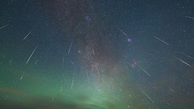
2015 August 13
Moonless Meteors and the Milky Way
* Image Credit & Copyright: Petr Horálek
https://www.petrhoralek.com/?page_id=20
Explanation:
Have you watched the Perseid meteor shower? Though the annual shower's predicted peak was last night, meteor activity should continue tonight (August 13/14), best enjoyed by just looking up in clear, dark skies after midnight. Of course, this year's Perseid shower has the advantage of being active near the August 14 New Moon. Since the nearly New Moon doesn't rise before the morning twilight many fainter meteors are easier to spot until then, with no interference from bright moonlight. The Perseid meteor shower last occurred near a New Moon in 2013. That's when the exposures used to construct this image were made, under dark, moonless skies from Hvar Island off the coast of Croatia. The widefield composite includes 67 meteors streaming from the heroic constellation Perseus, the shower's radiant, captured during 2013 August 8-14 against a background of faint zodiacal light and the Milky Way.
https://www.petrhoralek.com/?p=42
https://apod.nasa.gov/apod/ap150813.html
#space #galaxy #perseids #astrophotography #photography #science #astronomy #nature #NASA
, best enjoyed by just looking up in clear, dark skies after midnight. Of course, this year's Perseid shower has the advantage of being active near the August 14 New Moon. Since the nearly New Moon doesn't rise before the morning twilight many fainter meteors are easier to spot until then, with no interference from bright moonlight. The Perseid meteor shower last occurred near a New Moon in 2013. That's when the exposures used to construct this image were made, under dark, moonless skies from Hvar Island off the coast of Croatia. The widefield composite includes 67 meteors streaming from the heroic constellation Perseus, the shower's radiant, captured during 2013 August 8-14 against a background of faint zodiacal light and the Milky Way.
Authors & editors: Robert Nemiroff (MTU) & Jerry Bonnell (UMCP)
NASA Official: Phillip Newman Specific rights apply.
NASA Web Privacy Policy and Important Notices
A service of: ASD at NASA / GSFC
& Michigan Tech. U.")
Alt...
2015 August 13
Moonless Meteors and the Milky Way
* Image Credit & Copyright: Petr Horálek
Explanation:
Have you watched the Perseid meteor shower? Though the annual shower's predicted peak was last night, meteor activity should continue tonight (August 13/14), best enjoyed by just looking up in clear, dark skies after midnight. Of course, this year's Perseid shower has the advantage of being active near the August 14 New Moon. Since the nearly New Moon doesn't rise before the morning twilight many fainter meteors are easier to spot until then, with no interference from bright moonlight. The Perseid meteor shower last occurred near a New Moon in 2013. That's when the exposures used to construct this image were made, under dark, moonless skies from Hvar Island off the coast of Croatia. The widefield composite includes 67 meteors streaming from the heroic constellation Perseus, the shower's radiant, captured during 2013 August 8-14 against a background of faint zodiacal light and the Milky Way.
Authors & editors: Robert Nemiroff (MTU) & Jerry Bonnell (UMCP)
NASA Official: Phillip Newman Specific rights apply.
NASA Web Privacy Policy and Important Notices
A service of: ASD at NASA / GSFC
& Michigan Tech. U.
2025 August 15
Moonlight, Planets, and Perseids
* Image Credit & Copyright: Jeff Dai (TWAN)
https://twanight.org/profile/jeff-dai/
Explanation:
In the predawn sky on August 13, two planets were close. And despite the glare of a waning gibbous Moon, bright Jupiter and even brighter Venus were hard to miss. Their brilliant close conjunction is posing above the eastern horizon in this early morning skyscape. The scene was captured in a single exposure from a site near Gansu, China, with light from both planets reflected in the still waters of a local pond. Also seen against the moonlight were flashes from the annual Perseid Meteor Shower, known for its bright, fast meteors. Near the much anticipated peak of activity, the shower meteors briefly combined with the two planets for a celestial spectacle even in moonlit skies.
https://science.nasa.gov/solar-system/whats-up-august-2025-skywatching-tips-from-nasa/#hds-sidebar-nav-1
https://science.nasa.gov/solar-system/whats-up-august-2025-skywatching-tips-from-nasa/#hds-sidebar-nav-1
https://www.nasa.gov/blogs/watch-the-skies/2025/08/08/bright-moonlight-could-interfere-with-view-of-perseids-peak/
https://earthsky.org/todays-image/venus-and-jupiter/
#space #galaxy #perseids #astrophotography #photography #science #astronomy #nature #NASA

Explanation:
In the predawn sky on August 13, two planets were close. And despite the glare of a waning gibbous Moon, bright Jupiter and even brighter Venus were hard to miss. Their brilliant close conjunction is posing above the eastern horizon in this early morning skyscape. The scene was captured in a single exposure from a site near Gansu, China, with light from both planets reflected in the still waters of a local pond. Also seen against the moonlight were flashes from the annual Perseid Meteor Shower, known for its bright, fast meteors. Near the much anticipated peak of activity, the shower meteors briefly combined with the two planets for a celestial spectacle even in moonlit skies.
Authors & editors: Robert Nemiroff (MTU) & Jerry Bonnell (UMCP)
NASA Official: Amber Straughn Specific rights apply.
NASA Web Privacy, Accessibility, Notices;
A service of: ASD at NASA / GSFC,
NASA Science Activation
& Michigan Tech. U.")
Alt...
2025 August 15
Moonlight, Planets, and Perseids
* Image Credit & Copyright: Jeff Dai (TWAN)
Explanation:
In the predawn sky on August 13, two planets were close. And despite the glare of a waning gibbous Moon, bright Jupiter and even brighter Venus were hard to miss. Their brilliant close conjunction is posing above the eastern horizon in this early morning skyscape. The scene was captured in a single exposure from a site near Gansu, China, with light from both planets reflected in the still waters of a local pond. Also seen against the moonlight were flashes from the annual Perseid Meteor Shower, known for its bright, fast meteors. Near the much anticipated peak of activity, the shower meteors briefly combined with the two planets for a celestial spectacle even in moonlit skies.
Authors & editors: Robert Nemiroff (MTU) & Jerry Bonnell (UMCP)
NASA Official: Amber Straughn Specific rights apply.
NASA Web Privacy, Accessibility, Notices;
A service of: ASD at NASA / GSFC,
NASA Science Activation
& Michigan Tech. U.
2025 August 16
A Cool GIF of a 2025 Perseid
* Image Credit & Copyright: Renaud & Olivier Coppe
https://app.astrobin.com/u/ren1450#gallery
Explanation:
The camera battery died about 2am local time on August 12, while shooting in the bright moonlit skies from a garden in Chastre, Brabant Wallon, Belgium, planet Earth. But not before it captured the frames used to compose this cool animated gif of a brilliant Perseid meteor and a lingering visible trail known as a persistent train. The Perseid meteor, a fast moving speck of dust from the tail of large periodic Comet Swift-Tuttle, was heated to incandescence by ram pressure and vaporized as it flashed through the upper atmosphere at 60 kilometers per second. Compared to the brief flash of the meteor, its wraith-like trail really is persistent. A characteristic of bright meteors, a smoke-like persistent train can often be followed for many minutes wafting in the winds at altitudes of 60 to 90 kilometers.
https://www.nasa.gov/blogs/watch-the-skies/2025/08/08/bright-moonlight-could-interfere-with-view-of-perseids-peak/
https://apod.nasa.gov/apod/ap180817.html
https://apod.nasa.gov/apod/ap250816.html
#space #galaxy #perseids #astrophotography #photography #science #astronomy #nature #NASA
109P/Swift-Tuttle
by Alicia Cermak - NASA
Comet Swift-Tuttle was discovered in 1862 independently by both Lewis Swift and Horace Tuttle.
Overview
Comet 109P/Swift-Tuttle takes 133 years to orbit the Sun once. Swift-Tuttle last reached perihelion (closest approach to the Sun) in 1992 and will return again in 2125.
Swift-Tuttle is a large comet – its nucleus is 16 miles (26 kilometers) across. (That is more than twice the size of the object hypothesized to have led the demise of the dinosaurs.)
The pieces of space debris that interact with our atmosphere to create the popular Perseids meteor shower originate from Swift-Tuttle. This annual meteor shower takes place each August, and peaks mid-month. It was Giovanni Schiaparelli who realized in 1865 that this comet was the source of the Perseids.
When comets come around the Sun, the dust they emit gradually spreads into a dusty trail around their orbits. Every year the Earth passes through these debris trails, which allows the bits to collide with our atmosphere where they disintegrate to create fiery and colorful streaks in the sky.
How This Comet Got Its Name
+ Comets are usually named for their discoverer(s) or for the name of the observatory/telescope used in the discovery. Since both Lewis Swift and Horace Tuttle discovered this comet it is named for them. The letter "P" indicates that Swift-Tuttle is a "periodic" comet. Periodic comets have an orbital period of less than 200 years
Credits
NASA/Preston Dyches
Alicia Cermak
https://science.nasa.gov/solar-system/comets/109p-swift-tuttle/
#space #galaxy #perseids #astrophotography #photography #science #astronomy #nature #NASA

Alt...
A view of the 2023 Perseid meteor shower from the southernmost part of Sequoia National Forest, near Piute Peak. Debris from comet Swift-Tuttle creates the Perseids.
NASA/Preston Dyches
2025 August 20
Perseid Meteors from Durdle Door
* Image Credit & Copyright: Josh Dury
https://www.joshduryphoto-media.com/
Explanation:
What are those curved arcs in the sky? Meteors -- specifically, meteors from this year's Perseid meteor shower. Over the past few weeks, after the sky darkened, many images of Perseid meteors were captured separately and merged into a single frame, taken earlier. Although the meteors all traveled on straight paths, these paths appear slightly curved by the wide-angle lens of the capturing camera. The meteor streaks can all be traced back to a single point on the sky called the radiant, here just off the top of the frame in the constellation of Perseus. The same camera took a deep image of the background sky that brought up the central band of our Milky Way galaxy running nearly vertically through the featured image's center. The limestone arch in the foreground in Dorset, England is known as Durdle Door, a name thought to survive from a thousand years ago.
https://en.wikipedia.org/wiki/Durdle_Door
https://www.youtube.com/watch?v=JYDRQFA51N0
https://apod.nasa.gov/apod/ap240811.html
https://apod.nasa.gov/apod/ap250820.html
#space #galaxy #perseids #astrophotography #photography #science #astronomy #nature #NASA
 & Jerry Bonnell (UMCP)
NASA Official: Amber Straughn Specific rights apply.
NASA Web Privacy, Accessibility, Notices;
A service of: ASD at NASA / GSFC,
NASA Science Activation
& Michigan Tech. U.")
Alt...
2025 August 20
A deep sky is shown with the band of our Milky Way Galaxy running from the upper left to the lower right. The streaks or many curved meteors are seen. In the foreground a beach is seen with an unusual rock outcrop that has an opening.
Perseid Meteors from Durdle Door
* Image Credit & Copyright: Josh Dury
Explanation:
What are those curved arcs in the sky? Meteors -- specifically, meteors from this year's Perseid meteor shower. Over the past few weeks, after the sky darkened, many images of Perseid meteors were captured separately and merged into a single frame, taken earlier. Although the meteors all traveled on straight paths, these paths appear slightly curved by the wide-angle lens of the capturing camera. The meteor streaks can all be traced back to a single point on the sky called the radiant, here just off the top of the frame in the constellation of Perseus. The same camera took a deep image of the background sky that brought up the central band of our Milky Way galaxy running nearly vertically through the featured image's center. The limestone arch in the foreground in Dorset, England is known as Durdle Door, a name thought to survive from a thousand years ago.
Authors & editors: Robert Nemiroff (MTU) & Jerry Bonnell (UMCP)
NASA Official: Amber Straughn Specific rights apply.
NASA Web Privacy, Accessibility, Notices;
A service of: ASD at NASA / GSFC,
NASA Science Activation
& Michigan Tech. U.
2025 August 21
Mostly Perseids
* Image Credit & Copyright: Klaus Pillwatsch
https://www.instagram.com/p_i_k_a_s_s/
Explanation:
In this predawn skyscape recorded during the early morning hours of August 13, mostly Perseid meteors are raining down on planet Earth. You can easily identify the Perseid meteor streaks. They're the ones with trails that seem to converge on the annual meteor shower's radiant, a spot in the heroic constellation Perseus, located off the top of the frame. That's the direction in Earth's sky that looks along the orbit of this meteor shower's parent, periodic Comet Swift-Tuttle. Of course the scene is a composite, a combination of about 500 digital exposures to capture meteors registered with a single base frame exposure. But all exposures were taken during a period of around 2.5 hours from a wind farm near Mönchhof, Burgenland, Austria. Red lights on the individual wind turbine towers dot the foreground. In their spectacular close conjunction, bright planets Jupiter and Venus are poised above the eastern horizon.
https://apod.nasa.gov/apod/ap250821.html
#space #perseids #astrophotography #photography #science #astronomy #nature #NASA
 & Jerry Bonnell (UMCP)
NASA Official: Amber Straughn Specific rights apply.
NASA Web Privacy, Accessibility, Notices;
A service of: ASD at NASA / GSFC,
NASA Science Activation
& Michigan Tech. U.")
Alt...
2025 August 21
Mostly Perseids
* Image Credit & Copyright: Klaus Pillwatsch
Explanation:
In this predawn skyscape recorded during the early morning hours of August 13, mostly Perseid meteors are raining down on planet Earth. You can easily identify the Perseid meteor streaks. They're the ones with trails that seem to converge on the annual meteor shower's radiant, a spot in the heroic constellation Perseus, located off the top of the frame. That's the direction in Earth's sky that looks along the orbit of this meteor shower's parent, periodic Comet Swift-Tuttle. Of course the scene is a composite, a combination of about 500 digital exposures to capture meteors registered with a single base frame exposure. But all exposures were taken during a period of around 2.5 hours from a wind farm near Mönchhof, Burgenland, Austria. Red lights on the individual wind turbine towers dot the foreground. In their spectacular close conjunction, bright planets Jupiter and Venus are poised above the eastern horizon.
Authors & editors: Robert Nemiroff (MTU) & Jerry Bonnell (UMCP)
NASA Official: Amber Straughn Specific rights apply.
NASA Web Privacy, Accessibility, Notices;
A service of: ASD at NASA / GSFC,
NASA Science Activation
& Michigan Tech. U.
2025 August 25
The Meteor and the Star Cluster
* Image Credit & Copyright: Yousif Alqasimi & Essa Al Jasmi
https://www.instagram.com/alqasmyi/
https://www.instagram.com/eaqj/
Explanation:
Sometimes even the sky surprises you. To see more stars and faint nebulosity in the Pleiades star cluster (M45), long exposures are made. Many times, less interesting items appear on the exposures that were not intended -- but later edited out. These include stuck pixels, cosmic ray hits, frames with bright clouds or Earth's Moon, airplane trails, lens flares, faint satellite trails, and even insect trails. Sometimes, though, something really interesting is caught by chance. That was just the case a few weeks ago in al-Ula, Saudi Arabia when a bright meteor streaked across during an hour-long exposure of the Pleiades. Along with the famous bright blue stars, less famous and less bright blue stars, and blue-reflecting dust surrounding the star cluster, the fast rock fragment created a distinctive green glow, likely due to vaporized metals.
https://science.nasa.gov/mission/hubble/science/explore-the-night-sky/hubble-messier-catalog/messier-45/
https://en.wikipedia.org/wiki/Pleiades
https://apod.nasa.gov/apod/ap250825.html
#space #perseids #astrophotography #photography #science #astronomy #nature #NASA
, long exposures are made. Many times, less interesting items appear on the exposures that were not intended -- but later edited out. These include stuck pixels, cosmic ray hits, frames with bright clouds or Earth's Moon, airplane trails, lens flares, faint satellite trails, and even insect trails. Sometimes, though, something really interesting is caught by chance. That was just the case a few weeks ago in al-Ula, Saudi Arabia when a bright meteor streaked across during an hour-long exposure of the Pleiades. Along with the famous bright blue stars, less famous and less bright blue stars, and blue-reflecting dust surrounding the star cluster, the fast rock fragment created a distinctive green glow, likely due to vaporized metals.
Authors & editors: Robert Nemiroff (MTU) & Jerry Bonnell (UMCP)
NASA Official: Amber Straughn Specific rights apply.
NASA Web Privacy, Accessibility, Notices;
A service of: ASD at NASA / GSFC,
NASA Science Activation
& Michigan Tech. U.")
Alt...
2025 August 25
A starfield surrounds the bright blue stars of a star cluster: the Pleiades star cluster. Nearly horizontally across the cluster is a bright green streak, most likely a meteor.
The Meteor and the Star Cluster
* Image Credit & Copyright: Yousif Alqasimi & Essa Al Jasmi
Explanation:
Sometimes even the sky surprises you. To see more stars and faint nebulosity in the Pleiades star cluster (M45), long exposures are made. Many times, less interesting items appear on the exposures that were not intended -- but later edited out. These include stuck pixels, cosmic ray hits, frames with bright clouds or Earth's Moon, airplane trails, lens flares, faint satellite trails, and even insect trails. Sometimes, though, something really interesting is caught by chance. That was just the case a few weeks ago in al-Ula, Saudi Arabia when a bright meteor streaked across during an hour-long exposure of the Pleiades. Along with the famous bright blue stars, less famous and less bright blue stars, and blue-reflecting dust surrounding the star cluster, the fast rock fragment created a distinctive green glow, likely due to vaporized metals.
Authors & editors: Robert Nemiroff (MTU) & Jerry Bonnell (UMCP)
NASA Official: Amber Straughn Specific rights apply.
NASA Web Privacy, Accessibility, Notices;
A service of: ASD at NASA / GSFC,
NASA Science Activation
& Michigan Tech. U.
This clip of Orientale Basin was made with data from the Lunar Reconnaissance Orbiter by NASA's Scientific Visualization Studio.
Image credit: NASA’s Scientific Visualization Studio/Ernie Wright
https://moon.nasa.gov/observe-the-moon-night/participate/10-ways-to-observe-the-moon/
https://moon.nasa.gov/observe-the-moon-night/resources/moon-map/
#space #moon #astrophotography #photography #science #astronomy #nature #NASA #education
Join In!
The countdown is on.. for the International Observe the Moon Night 2025 on October 4!
https://moon.nasa.gov/observe-the-moon-night/
https://moon.nasa.gov/observe-the-moon-night/register/individual-participation/
#space #moon #astrophotography #photography #science #astronomy #nature #NASA #education
2025 October 4
The Rotating Moon
* Video Credit: NASA, Lunar Reconnaissance Orbiter, Arizona State U.
https://www.nasa.gov/
https://science.nasa.gov/mission/lro/
https://www.lroc.asu.edu/about/team
Explanation:
No one on Earth sees the Moon rotate like this. That's because the Moon is tidally locked in synchronous rotation, showing only one side to denizens of our fair planet. Still, given modern digital technology, combined with many detailed images returned by the Lunar Reconnaissance Orbiter (LRO), a high resolution virtual Moon rotation movie can be composed. In fact, the featured time-lapse video starts with a view of the familiar lunar nearside and quickly finds the Mare Orientale, a large crater with a dark center that is difficult to see from the Earth, rotating into view just below the equator. In a complete lunar rotation condensed into 24 seconds, the video clearly shows that the Earth-facing nearside of the Moon contains an abundance of dark lunar maria, while the lunar farside is dominated by bright lunar highlands. Of course you can just join other moon-watchers under hopefully clear skies tonight. Check out the sunlit portion of the lunar nearside on International Observe the Moon Night.
https://en.wikipedia.org/wiki/List_of_plains_on_the_Moon
https://en.wikipedia.org/wiki/Geology_of_the_Moon#Highlands
https://moon.nasa.gov/observe-the-moon-night/
https://lroc.im-ldi.com/about
https://apod.nasa.gov/apod/fap/ap251004.html
#space #moon #astrophotography #photography #science #astronomy #nature #NASA #education
The Moon’s Rotation
An enduring myth about the Moon is that it doesn't rotate. While it's true that the Moon keeps the same face to us, this only happens because the Moon rotates at the same rate as its orbital motion, a special case of tidal locking called synchronous rotation. The animation shows both the orbit and the rotation of the Moon. The yellow circle with the arrow and radial line have been added to make the rotation more apparent. The arrow indicates the direction of rotation. The radial line points to the center of the visible disk of the Moon at 0°N 0°E.
Credit:
NASA's Scientific Visualization Studio
Visualizer:
Ernie Wright (USRA)
Technical support
Laurence Schuler (ADNET Systems, Inc.)
Ian Jones (ADNET Systems, Inc.)
#space #moon #astrophotography #photography #science #astronomy #nature #NASA #education
2025 October 1
NGC 6960: The Witch's Broom Nebula
* Image Credit & Copyright: Brian Meyers
Explanation:
Ten thousand years ago, before the dawn of recorded human history, a new light would suddenly have appeared in the night sky and faded after a few weeks. Today we know this light was from a supernova, or exploding star, and record the expanding debris cloud as the Veil Nebula, a supernova remnant. This sharp telescopic view is centered on a western segment of the Veil Nebula cataloged as NGC 6960 but less formally known as the Witch's Broom Nebula. Blasted out in the cataclysmic explosion, an interstellar shock wave plows through space sweeping up and exciting interstellar material. Imaged with narrow band filters, the glowing filaments are like long ripples in a sheet seen almost edge on, remarkably well separated into atomic hydrogen (red) and oxygen (blue-green) gas. The complete supernova remnant lies about 1400 light-years away towards the constellation Cygnus. This Witch's Broom actually spans about 35 light-years. The bright star in the frame is 52 Cygni, visible with the unaided eye from a dark location but unrelated to the ancient supernova remnant.
https://apod.nasa.gov/apod/ap251001.html
https://en.wikipedia.org/wiki/List_of_supernova_remnants
https://chandra.harvard.edu/xray_sources/supernovas.html
https://en.wikipedia.org/wiki/File:Cygnus_Loop_Labeled.png
https://apod.nasa.gov/apod/ap101119.html
https://apod.nasa.gov/apod/ap251001.html
#space #nebula #cluster #astrophotography #photography #science #astronomy #nature #NASA #ESA #education
 and oxygen (blue-green) gas. The complete supernova remnant lies about 1400 light-years away towards the constellation Cygnus. This Witch's Broom actually spans about 35 light-years. The bright star in the frame is 52 Cygni, visible with the unaided eye from a dark location but unrelated to the ancient supernova remnant.
Authors & editors: Robert Nemiroff (MTU) & Jerry Bonnell (UMCP)
NASA Official: Amber Straughn Specific rights apply.")
Alt...
2025 October 1
A starfield is shown that has a multi-filament nebula flowing across it horizontally. The most prominent colors are red and blue. Please see the explanation for more detailed information.
NGC 6960: The Witch's Broom Nebula
* Image Credit & Copyright: Brian Meyers
Explanation:
Ten thousand years ago, before the dawn of recorded human history, a new light would suddenly have appeared in the night sky and faded after a few weeks. Today we know this light was from a supernova, or exploding star, and record the expanding debris cloud as the Veil Nebula, a supernova remnant. This sharp telescopic view is centered on a western segment of the Veil Nebula cataloged as NGC 6960 but less formally known as the Witch's Broom Nebula. Blasted out in the cataclysmic explosion, an interstellar shock wave plows through space sweeping up and exciting interstellar material. Imaged with narrow band filters, the glowing filaments are like long ripples in a sheet seen almost edge on, remarkably well separated into atomic hydrogen (red) and oxygen (blue-green) gas. The complete supernova remnant lies about 1400 light-years away towards the constellation Cygnus. This Witch's Broom actually spans about 35 light-years. The bright star in the frame is 52 Cygni, visible with the unaided eye from a dark location but unrelated to the ancient supernova remnant.
Authors & editors: Robert Nemiroff (MTU) & Jerry Bonnell (UMCP)
NASA Official: Amber Straughn Specific rights apply.
2025 September 30
Comet Lemmon Brightens
* Image Credit & Copyright: Victor Sabet & Julien De Winter
https://app.astrobin.com/i/lsnen5
Explanation:
Comet Lemmon is brightening and moving into morning northern skies. Besides Comet SWAN25B and Comet ATLAS, Comet C/2025 A6 (Lemmon) is now the third comet currently visible with binoculars and on long camera exposures. Comet Lemmon was discovered early this year and is still headed into the inner Solar System. The comet will round the Sun on November 8, but first it will pass its nearest to the Earth -- at about half the Earth-Sun distance -- on October 21. Although the brightnesses of comets are notoriously hard to predict, optimistic estimates have Comet Lemmon then becoming visible to the unaided eye. The comet should be best seen in predawn skies until mid-October, when it also becomes visible in evening skies. The featured image showing the comet's split and rapidly changing ion tail was taken in Texas, USA late last week.
https://en.wikipedia.org/wiki/C/2025_A6_(Lemmon)
https://earthsky.org/space/5-bright-comets-approaching-earth-charts-2025-2026/
https://theskylive.com/c2025a6-info
https://science.nasa.gov/solar-system/comets/facts/
https://en.wikipedia.org/wiki/Comet_tail
https://en.wikipedia.org/wiki/Astronomical_unit
https://apod.nasa.gov/apod/ap250930.html
#space #comets #astrophotography #photography #science #astronomy #nature #NASA #ESA #education
 is now the third comet currently visible with binoculars and on long camera exposures. Comet Lemmon was discovered early this year and is still headed into the inner Solar System. The comet will round the Sun on November 8, but first it will pass its nearest to the Earth -- at about half the Earth-Sun distance -- on October 21. Although the brightnesses of comets are notoriously hard to predict, optimistic estimates have Comet Lemmon then becoming visible to the unaided eye. The comet should be best seen in predawn skies until mid-October, when it also becomes visible in evening skies. The featured image showing the comet's split and rapidly changing ion tail was taken in Texas, USA late last week.
Authors & editors: Robert Nemiroff (MTU) & Jerry Bonnell (UMCP)
NASA Official: Amber Straughn Specific rights apply.
NASA Web Privacy, Accessibility, Notices;
A service of: ASD at NASA / GSFC,
NASA Science Activation
& Michigan Tech. U.")
Alt...
2025 September 30
A starfield is shown that has a bright comet. The comet shows a green head on the lower left and an ion tail with significant structure extending out to the upper right.
Comet Lemmon Brightens
* Image Credit & Copyright: Victor Sabet & Julien De Winter
Explanation:
Comet Lemmon is brightening and moving into morning northern skies. Besides Comet SWAN25B and Comet ATLAS, Comet C/2025 A6 (Lemmon) is now the third comet currently visible with binoculars and on long camera exposures. Comet Lemmon was discovered early this year and is still headed into the inner Solar System. The comet will round the Sun on November 8, but first it will pass its nearest to the Earth -- at about half the Earth-Sun distance -- on October 21. Although the brightnesses of comets are notoriously hard to predict, optimistic estimates have Comet Lemmon then becoming visible to the unaided eye. The comet should be best seen in predawn skies until mid-October, when it also becomes visible in evening skies. The featured image showing the comet's split and rapidly changing ion tail was taken in Texas, USA late last week.
Authors & editors: Robert Nemiroff (MTU) & Jerry Bonnell (UMCP)
NASA Official: Amber Straughn Specific rights apply.
NASA Web Privacy, Accessibility, Notices;
A service of: ASD at NASA / GSFC,
NASA Science Activation
& Michigan Tech. U.
2025 September 29
Two Camera Comets in One Sky
* Image Credit & Copyright: Luc Perrot (TWAN)
https://www.lucperrot.fr/bio
Explanation:
It may look like these comets are racing, but they are not. Comets C/2025 K1 ATLAS (left) and C/2025 R2 SWAN (right) appeared near each other by chance last week in the featured image taken from France's Reunion Island in the southern Indian Ocean. Fainter Comet ATLAS is approaching our Sun and will reach its closest approach in early October when it is also expected to be its brightest -- although still only likely visible with long exposures on a camera. The brighter comet, nicknamed SWAN25B, is now headed away from our Sun, although its closest approach to Earth is expected in mid-October, when optimistic estimates have it becoming bright enough to see with the unaided eye. Each comet has a greenish coma of expelled gas and an ion tail pointing away from the Sun.
https://apod.nasa.gov/apod/ap250918.html
https://apod.nasa.gov/apod/ap250916.html
https://en.wikipedia.org/wiki/C/2025_K1_(ATLAS)
https://en.wikipedia.org/wiki/C/2025_R2_(SWAN)
https://en.wikipedia.org/wiki/Coma_(comet)
https://apod.nasa.gov/apod/ap250929.html
#space #comets #astrophotography #photography #science #astronomy #nature #NASA #ESA #education

Explanation:
It may look like these comets are racing, but they are not. Comets C/2025 K1 ATLAS (left) and C/2025 R2 SWAN (right) appeared near each other by chance last week in the featured image taken from France's Reunion Island in the southern Indian Ocean. Fainter Comet ATLAS is approaching our Sun and will reach its closest approach in early October when it is also expected to be its brightest -- although still only likely visible with long exposures on a camera. The brighter comet, nicknamed SWAN25B, is now headed away from our Sun, although its closest approach to Earth is expected in mid-October, when optimistic estimates have it becoming bright enough to see with the unaided eye. Each comet has a greenish coma of expelled gas and an ion tail pointing away from the Sun.
Authors & editors: Robert Nemiroff (MTU) & Jerry Bonnell (UMCP)
NASA Official: Amber Straughn Specific rights apply.
NASA Web Privacy, Accessibility, Notices;
A service of: ASD at NASA / GSFC,
NASA Science Activation
& Michigan Tech. U.")
Alt...
2025 September 29
A starfield is shown that has two short streaks running diagonally. At closer inspection, they are two comets both with white-green heads and white tails.
Two Camera Comets in One Sky
* Image Credit & Copyright: Luc Perrot (TWAN)
Explanation:
It may look like these comets are racing, but they are not. Comets C/2025 K1 ATLAS (left) and C/2025 R2 SWAN (right) appeared near each other by chance last week in the featured image taken from France's Reunion Island in the southern Indian Ocean. Fainter Comet ATLAS is approaching our Sun and will reach its closest approach in early October when it is also expected to be its brightest -- although still only likely visible with long exposures on a camera. The brighter comet, nicknamed SWAN25B, is now headed away from our Sun, although its closest approach to Earth is expected in mid-October, when optimistic estimates have it becoming bright enough to see with the unaided eye. Each comet has a greenish coma of expelled gas and an ion tail pointing away from the Sun.
Authors & editors: Robert Nemiroff (MTU) & Jerry Bonnell (UMCP)
NASA Official: Amber Straughn Specific rights apply.
NASA Web Privacy, Accessibility, Notices;
A service of: ASD at NASA / GSFC,
NASA Science Activation
& Michigan Tech. U.
![[?]](https://files.mastodon.social/accounts/avatars/110/656/272/811/063/860/original/5b4be034c236d08d.png)
Venus rewards stargazers with appearance next to moon
#PlanetaryAppearance #Astronomy #Stargazing #NightSky #Moon
https://www.theguardian.com/science/2025/jan/04/venus-rewards-stargazers-appearance-next-to-moon
Mars 2020: Perseverance Rover - NASA Science
latest news
New Report: Perseverance Rock Sample Contains 'Potential Biosignatures'
-- Alicia Cermak
A sample collected by NASA’s Perseverance Mars rover from an ancient dry riverbed in Jezero Crater could preserve evidence of ancient microbial life. Taken from a rock named “Cheyava Falls” last year, the sample, called “Sapphire Canyon,” contains potential biosignatures, according to a paper published Wednesday in the journal Nature.
https://science.nasa.gov/mission/mars-2020-perseverance/
Please read this article by Jessica Taveau as well:
https://www.nasa.gov/news-release/nasa-says-mars-rover-discovered-potential-biosignature-last-year/
also FYI:
https://youtu.be/-StZggK4hhA
#space #mars #astrophotography #photography #science #astronomy #geology #topography #nature #NASA #ESA
Perseverance Finds a Rock with ‘Leopard Spots’
NASA’s Perseverance Mars rover captured this image of a rock nicknamed “Cheyava Falls” on July 18, 2024, the 1,212th Martian day, or sol, of the mission. Running the length of the rock are large white calcium sulfate veins. Between those veins are bands of material whose reddish color suggests the presence of hematite, one of the minerals that gives Mars its distinctive rusty hue. Scientists are particularly interested in the millimeter-size, irregularly shaped light patches on the central reddish band (from lower left to upper right of the image) that are surrounded by a thin ring of dark material, akin to leopard spots. Spotting of this type on sedimentary terrestrial rocks can occur when chemical reactions involving hematite turn the rock from red to white. Those reactions can also release iron and phosphate, possibly causing the black halos to form, and they can be an energy source for microbes, hence the association between such features and microbes in a terrestrial setting.
Figure A is the same image with annotations pointing out the leopard spots and olivine in the rock.
Measuring 3.2 feet by 2 feet (1 meter by 0.6 meters) and named after a Grand Canyon waterfall, Cheyava Falls was found in an ancient riverbed within the “Bright Angel” region of Mars’ Jezero Crater. This image of the rock was captured using a camera called WATSON (Wide Angle Topographic Sensor for Operations and eNgineering), which is part of the SHERLOC (Scanning Habitable Environments with Raman and Luminescence for Organics and Chemicals) instrument suite located on the end of Perseverance’s 7-foot-long (2-meter-long) robotic arm. SHERLOC looks for organic compounds — carbon-based molecules that are considered the building blocks of life — and detected them in Cheyava Falls.
[...]
Read more in the ALT-Text
https://science.nasa.gov/resource/perseverance-finds-a-rock-with-leopard-spots/
#space #mars #astrophotography #photography #science #astronomy #geology #topography #nature #NASA #ESA
![Annotations for previous post.
An annotated version of the image of “Cheyava Falls” indicates the markings akin to leopard spots, which have particularly captivated scientists, and the olivine in the rock. The image was captured by the WATSON instrument on NASA’s Perseverance Mars rover on July 18.
[...]
The white, knobby material seen on either side of the spots is dotted with a few green olivine crystals, which form in igneous rocks such as lava flows. It’s unknown whether the olivine formed at the same time as the leopard spots; scientists hope to establish a timeline for when both the olivine and the spots formed.
Perseverance drilled a core from Cheyava Falls, the rover’s 22nd rock sample, on July 21.
A key objective for Perseverance’s mission on Mars is astrobiology, including the search for signs of ancient microbial life. The rover is also characterizing the planet’s geology and past climate, which paves the way for human exploration of the Red Planet. NASA’s Jet Propulsion Laboratory, which is managed for the agency by Caltech in Pasadena, California, built and manages operations of the Perseverance rover.](https://files.defcon.social/dcsocial-s3/media_attachments/files/115/280/447/084/194/586/original/8a280cd808556084.webp "Annotations for previous post.
An annotated version of the image of “Cheyava Falls” indicates the markings akin to leopard spots, which have particularly captivated scientists, and the olivine in the rock. The image was captured by the WATSON instrument on NASA’s Perseverance Mars rover on July 18.
[...]
The white, knobby material seen on either side of the spots is dotted with a few green olivine crystals, which form in igneous rocks such as lava flows. It’s unknown whether the olivine formed at the same time as the leopard spots; scientists hope to establish a timeline for when both the olivine and the spots formed.
Perseverance drilled a core from Cheyava Falls, the rover’s 22nd rock sample, on July 21.
A key objective for Perseverance’s mission on Mars is astrobiology, including the search for signs of ancient microbial life. The rover is also characterizing the planet’s geology and past climate, which paves the way for human exploration of the Red Planet. NASA’s Jet Propulsion Laboratory, which is managed for the agency by Caltech in Pasadena, California, built and manages operations of the Perseverance rover.")
Alt...
Annotations for previous post.
An annotated version of the image of “Cheyava Falls” indicates the markings akin to leopard spots, which have particularly captivated scientists, and the olivine in the rock. The image was captured by the WATSON instrument on NASA’s Perseverance Mars rover on July 18.
[...]
The white, knobby material seen on either side of the spots is dotted with a few green olivine crystals, which form in igneous rocks such as lava flows. It’s unknown whether the olivine formed at the same time as the leopard spots; scientists hope to establish a timeline for when both the olivine and the spots formed.
Perseverance drilled a core from Cheyava Falls, the rover’s 22nd rock sample, on July 21.
A key objective for Perseverance’s mission on Mars is astrobiology, including the search for signs of ancient microbial life. The rover is also characterizing the planet’s geology and past climate, which paves the way for human exploration of the Red Planet. NASA’s Jet Propulsion Laboratory, which is managed for the agency by Caltech in Pasadena, California, built and manages operations of the Perseverance rover.
2025 September 28
Leopard Spots on Martian Rocks
* Image Credit: NASA, JPL-Caltech, MSSS, Perseverance Rover
https://www.nasa.gov/
https://www.jpl.nasa.gov/
https://www.msss.com/
https://science.nasa.gov/mission/mars-2020-perseverance/
Explanation:
What is creating these unusual spots? Light-colored spots on Martian rocks, each surrounded by a dark border, were discovered last year by NASA's Perseverance Rover currently exploring Mars. Dubbed leopard spots because of their seemingly similarity to markings on famous Earth-bound predators, these curious patterns are being studied with the possibility they were created by ancient Martian life. The pictured spots measure only millimeters across and were discovered on a larger rock named Cheyava Falls. The exciting but unproven speculation is that long ago, microbes generated energy with chemical reactions that turned rock from red to white while leaving a dark biosignature ring, like some similarly appearing spots on Earth rocks. Although other non-biological explanations have not been ruled out, speculation focusing on this potential biological origin is causing much intrigue.
https://science.nasa.gov/resource/perseverance-finds-a-rock-with-leopard-spots/
https://science.nasa.gov/mars/
https://science.nasa.gov/mission/mars-2020-perseverance/
https://en.wikipedia.org/wiki/Microorganism
https://www.atlasobscura.com/articles/earliest-life-on-earth-rocks
https://en.wikipedia.org/wiki/Hematite#Mars
https://apod.nasa.gov/apod/ap250928.html
#space #mars #astrophotography #photography #science #astronomy #geology #topography #nature #NASA #ESA
 & Jerry Bonnell (UMCP)
NASA Official: Amber Straughn Specific rights apply.
NASA Web Privacy, Accessibility, Notices;
A service of: ASD at NASA / GSFC,
NASA Science Activation
& Michigan Tech. U")
Alt...
2025 September 28
Part of a large rock on Mars is shown being mostly orange. On the rock are several irregular light-colored areas surrounded by a dark border. The spots are only millimeters across but might be a remnant biosignature of ancient Martian life.
Leopard Spots on Martian Rocks
* Image Credit: NASA, JPL-Caltech, MSSS, Perseverance Rover
Explanation:
What is creating these unusual spots? Light-colored spots on Martian rocks, each surrounded by a dark border, were discovered last year by NASA's Perseverance Rover currently exploring Mars. Dubbed leopard spots because of their seemingly similarity to markings on famous Earth-bound predators, these curious patterns are being studied with the possibility they were created by ancient Martian life. The pictured spots measure only millimeters across and were discovered on a larger rock named Cheyava Falls. The exciting but unproven speculation is that long ago, microbes generated energy with chemical reactions that turned rock from red to white while leaving a dark biosignature ring, like some similarly appearing spots on Earth rocks. Although other non-biological explanations have not been ruled out, speculation focusing on this potential biological origin is causing much intrigue.
Authors & editors: Robert Nemiroff (MTU) & Jerry Bonnell (UMCP)
NASA Official: Amber Straughn Specific rights apply.
NASA Web Privacy, Accessibility, Notices;
A service of: ASD at NASA / GSFC,
NASA Science Activation
& Michigan Tech. U
TOPIC>
Mars
2025 June 15
Two images are shown side by side. On the left is a sunset seen from Earth, while on the right is a sunset seen from Mars. The Earth sunset is quite orange, while the Mars sunset is quite blue. The Sun appears angularly smaller from Mars than from the Earth.
Two Worlds, One Sun
* Left Image Credit & Copyright: Damia Bouic
https://www.planetary.org/profiles/damia-bouic
* Right Image Credit: NASA, JPL-Caltech, MSSS
https://www.msss.com/
* Digital processing: Damia Bouic
Explanation:
How different does sunset appear from Mars than from Earth? For comparison, two images of our common star were taken at sunset, one from Earth and one from Mars. These images were scaled to have the same angular width and are featured here side-by-side. A quick inspection will reveal that the Sun appears slightly smaller from Mars than from Earth. This makes sense since Mars is 50% further from the Sun than Earth. More striking, perhaps, is that the Martian sunset is noticeably bluer near the Sun than the typically orange colors near the setting Sun from Earth. The reason for the blue hues from Mars is not fully understood, but thought to be related to forward scattering properties of Martian dust. The terrestrial sunset was taken in 2012 March from Marseille, France, while the Martian sunset was captured in 2015 by NASA's robotic Curiosity rover from Gale crater on Mars.
https://www.db-prods.net/blog/2015/05/06/coucher-de-soleil-sur-mars/
https://www.planetary.org/articles/0506-sunset-on-mars
https://apod.nasa.gov/apod/ap140302.html
https://science.nasa.gov/mars/facts/
https://en.wikipedia.org/wiki/Mars
https://en.wikipedia.org/wiki/Gale_%28crater%29
https://en.wikipedia.org/wiki/Martian_regolith#Atmospheric_dust
https://science.nasa.gov/mission/msl-curiosity/
https://www.physicsclassroom.com/class/light/Lesson-2/Blue-Skies-and-Red-Sunsets
https://en.wikipedia.org/wiki/Astronomy_on_Mars#The_color_of_the_sky
https://www.youtube.com/watch?v=IXSIZcj8WgA
https://www.msss.com/
https://science.nasa.gov/sun/
https://hudsonvalleygeologist.blogspot.com/2012/04/size-of-sun.html
https://hudsonvalleygeologist.blogspot.com/2012/04/size-of-sun.html
https://apod.nasa.gov/apod/ap220206.html
https://science.nasa.gov/earth/
https://apod.nasa.gov/apod/ap980526.html
https://apod.nasa.gov/apod/ap250615.html
#space #mars #sun #earth #astrophotography #photography #science #astronomy #nature #NASA #physics
 & Jerry Bonnell (UMCP)
NASA Official: Amber Straughn Specific rights apply.
NASA Web Privacy, Accessibility, Notices;
A service of: ASD at NASA / GSFC,
NASA Science Activation
& Michigan Tech. U.")
Alt...
Two Worlds, One Sun
* Left Image Credit & Copyright: Damia Bouic;
* Right Image Credit: NASA, JPL-Caltech, MSSS;
* Digital processing: Damia Bouic
Explanation:
How different does sunset appear from Mars than from Earth? For comparison, two images of our common star were taken at sunset, one from Earth and one from Mars. These images were scaled to have the same angular width and are featured here side-by-side. A quick inspection will reveal that the Sun appears slightly smaller from Mars than from Earth. This makes sense since Mars is 50% further from the Sun than Earth. More striking, perhaps, is that the Martian sunset is noticeably bluer near the Sun than the typically orange colors near the setting Sun from Earth. The reason for the blue hues from Mars is not fully understood, but thought to be related to forward scattering properties of Martian dust. The terrestrial sunset was taken in 2012 March from Marseille, France, while the Martian sunset was captured in 2015 by NASA's robotic Curiosity rover from Gale crater on Mars.
Authors & editors: Robert Nemiroff (MTU) & Jerry Bonnell (UMCP)
NASA Official: Amber Straughn Specific rights apply.
NASA Web Privacy, Accessibility, Notices;
A service of: ASD at NASA / GSFC,
NASA Science Activation
& Michigan Tech. U.
Mars missions: A brief history
By Elizabeth Howell, Vicky Stein, Daisy Dobrijevic
Mars missions have been launching for over 50 years but not every mission ends in success.
Mars missions have been launching from Earth with regularity since the 1960s, bent on exploring our planetary neighbor. With its potential for liquid water — and therefore, life — Mars is an alluring target.
But it's a difficult journey, and only about half of all Mars missions successfully make it to the Red Planet, according to NASA. A "Great Galactic Ghoul" must be consuming them, joked a journalist and a NASA scientist corresponding in 1964, reported the Economist.
Since the first successful flyby in 1965, several space agencies have successfully made it to Mars. NASA, the former Soviet Union space program, the European Space Agency (ESA) and the Indian Space Research Organization each met with earlier successes.
A significant batch of Mars-bound missions arrived in February 2021. NASA's Perseverance rover and Ingenuity helicopter reached Mars that month, along with the United Arab Emirates' Hope orbiter (a first interplanetary mission for that country) and the China National Space Administration's Tianwen-1 orbiter and lander-rover mission, which was China's first successful mission to the Red Planet.
Coming up in the 2020s and 2030s, the Japan Aerospace Exploration Agency (JAXA) is planning a sample-return mission from Mars' moon Phobos, and NASA has teamed up with the ESA on a sample-return mission from Mars itself.
Read more:>>
https://www.space.com/13558-historic-mars-missions.html
#space #mars #earth #astrophotography #photography #science #astronomy #nature #NASA

Alt...
The Mars Exploration Family Portrait shows every dedicated space mission to Mars.
Credit:
NASA/JPL/Roscosmos/JAXA/ESA/ISRO/MBRSC/Jason Davis/The Planetary Society
“Landing on Mars”
(59 min)
In the summer of 2003, two NASA rovers began their journeys to Mars at a time when the Red Planet and Earth were the nearest they had been to each other in 60,000 years. To capitalize on this alignment, the rovers had been built at breakneck speed by teams at NASA’s Jet Propulsion Laboratory. The mission came amid further pressures, from mounting international competition to increasing public scrutiny following the loss of the space shuttle Columbia and its crew of seven. NASA was in great need of a success.
“Landing on Mars” is the story of Opportunity and Spirit surviving a massive solar flare during cruise, the now well-known “six minutes of terror,” and what came close to being a mission-ending software error for the first rover once it was on the ground.
#space #mars #sun #earth #astrophotography #photography #science #astronomy #nature #NASA #physics
https://eyes.nasa.gov/apps/solar-system/#/mars
"This link will take you directly to the maximized full screen of the interactive 3D simulation with many different options. Have fun exploring .."
The fourth planet from the Sun, Mars is a dusty, cold, desert world with a very thin atmosphere.
Mars was named by the ancient Romans for their god of war because its reddish color was reminiscent of blood. The Red Planet is actually many colors. At the surface we see colors such as brown, gold and tan. The reason Mars looks reddish is due to oxidization—or rusting—of iron in the rocks, regolith (Martian “soil”), and dust of Mars. This dust gets kicked up into the atmosphere and from a distance makes the planet appear mostly red. Mars is home to the largest volcano in the solar system, Olympus Mons. It's three times taller than Earth's Mt. Everest with a base the size of the state of New Mexico.
Mars appears to have had a watery past, with ancient river valley networks, deltas and lakebeds, as well as rocks and minerals on the surface that could only have formed in liquid water. Some features suggest that Mars experienced huge floods about 3.5 billion years ago. There is water on Mars today, but the Martian atmosphere is too thin for liquid water to exist for long on the surface. Today, water on Mars is found in the form of water-ice just under the surface in the polar regions as well as in briny (salty) water, which seasonally flows down some hillsides and crater walls.
No planet beyond Earth has been studied as intensely as Mars. Today, a science fleet of robotic spacecraft study Mars from all angles.
#space #mars #sun #earth #astrophotography #photography #science #astronomy #nature #NASA
Curiosity wraps up an investigation at Mars' Pink Cliffs while trying out a style of exploration used by geologists on Earth called “the walkabout.”
Part of NASA's Mars Science Laboratory mission, Curiosity, was the largest and most capable rover ever sent to Mars when it launched in 2011. Curiosity set out to answer the question: Did Mars ever have the right environmental conditions to support small life forms called microbes? Early in its mission, Curiosity's scientific tools found chemical and mineral evidence of past habitable environments on Mars. It continues to explore the rock record from a time when Mars could have been home to microbial life.
https://science.nasa.gov/mission/msl-curiosity/
#space #mars #sun #earth #science #astronomy #geology #tech #nature #NASA #MarsRoverCuriosity

Alt...
Curiosity wraps up an investigation at Mars' Pink Cliffs while trying out a style of exploration used by geologists on Earth called “the walkabout.”
2025 June 21
Two Worlds, Two Analemmas
* Image Credit: (left) Copyright: Tunc Tezel (TWAN) https://twanight.org/profile/tunc-tezel/ - (right): NASA/JPL/Cornell/ASU/TAMU https://www.nasa.gov/
Explanation:
Sure, that figure-8 shaped curve you get when you mark the position of the Sun in Earth's sky at the same time each day over one year is called an analemma. On the left, Earth's figure-8 analemma was traced by combining wide-angle digital images recorded during the year from December 2011 through December 2012. But the shape of an analemma depends on the eccentricity of a planet's orbit and the tilt of its axis of rotation, so analemma curves can look different for different worlds. Take Mars for example. The Red Planet's axial tilt is similar to Earth's, but its orbit around the same sun is more eccentric (less circular) than Earth's orbit. As seen from the Martian surface, the analemma traced in the right hand panel is shaped more like a tear drop. The Mars rover Opportunity captured the images used over the Martian year corresponding to Earth dates July 2006 to June 2008. Of course, each world's solstice dates still lie at the top and bottom of their different analemma curves. The last Mars northern summer solstice was May 29, 2025. Our fair planet's 2025 northern summer solstice is at June 21, 2:42 UTC.
Earth:
https://apod.nasa.gov/apod/ap131014.html
https://apod.nasa.gov/apod/ap241204.html
https://apod.nasa.gov/apod/ap250320.html
Mars:
https://www.planetary.org/articles/a-martian-analemma
https://www.planetary.org/articles/mars-calendar
https://en.wikipedia.org/wiki/Analemma#Seen_from_other_planets
https://analemma.com/other-analemmas.html
https://apod.nasa.gov/apod/ap250621.html
#space #mars #sun #earth #astrophotography #photography #science #astronomy #nature #NASA #physics
 Copyright: Tunc Tezel (TWAN) - (right): NASA/JPL/Cornell/ASU/TAMU
Explanation:
Sure, that figure-8 shaped curve you get when you mark the position of the Sun in Earth's sky at the same time each day over one year is called an analemma. On the left, Earth's figure-8 analemma was traced by combining wide-angle digital images recorded during the year from December 2011 through December 2012. But the shape of an analemma depends on the eccentricity of a planet's orbit and the tilt of its axis of rotation, so analemma curves can look different for different worlds. Take Mars for example. The Red Planet's axial tilt is similar to Earth's, but its orbit around the same sun is more eccentric (less circular) than Earth's orbit. As seen from the Martian surface, the analemma traced in the right hand panel is shaped more like a tear drop. The Mars rover Opportunity captured the images used over the Martian year corresponding to Earth dates July 2006 to June 2008. Of course, each world's solstice dates still lie at the top and bottom of their different analemma curves. The last Mars northern summer solstice was May 29, 2025. Our fair planet's 2025 northern summer solstice is at June 21, 2:42 UTC.
Authors & editors: Robert Nemiroff (MTU) & Jerry Bonnell (UMCP)
NASA Official: Amber Straughn Specific rights apply.")
Alt...
2025 June 21
Two Worlds, Two Analemmas
* Image Credit: (left) Copyright: Tunc Tezel (TWAN) - (right): NASA/JPL/Cornell/ASU/TAMU
Explanation:
Sure, that figure-8 shaped curve you get when you mark the position of the Sun in Earth's sky at the same time each day over one year is called an analemma. On the left, Earth's figure-8 analemma was traced by combining wide-angle digital images recorded during the year from December 2011 through December 2012. But the shape of an analemma depends on the eccentricity of a planet's orbit and the tilt of its axis of rotation, so analemma curves can look different for different worlds. Take Mars for example. The Red Planet's axial tilt is similar to Earth's, but its orbit around the same sun is more eccentric (less circular) than Earth's orbit. As seen from the Martian surface, the analemma traced in the right hand panel is shaped more like a tear drop. The Mars rover Opportunity captured the images used over the Martian year corresponding to Earth dates July 2006 to June 2008. Of course, each world's solstice dates still lie at the top and bottom of their different analemma curves. The last Mars northern summer solstice was May 29, 2025. Our fair planet's 2025 northern summer solstice is at June 21, 2:42 UTC.
Authors & editors: Robert Nemiroff (MTU) & Jerry Bonnell (UMCP)
NASA Official: Amber Straughn Specific rights apply.
March 5, 2024: NASA released images of transits of the moon Deimos, the moon Phobos and the planet Mercury as viewed by the Perseverance rover on the planet Mars.
Solar 'eclipses' on Mars
The two moons of Mars, Phobos and Deimos, are much smaller than Earth's Moon, greatly reducing the frequency of solar eclipses on that planet. Neither moon's apparent diameter is large enough to cover the disk of the Sun, and therefore they are annular solar eclipses and can also be considered transits.
Eclipses caused by Phobos
Due to the small size of Phobos (about 20 by 25 km (12 by 16 mi)) and its rapid orbital motion, an observer on the surface of Mars would never experience a solar eclipse for longer than about thirty seconds. Phobos also takes only 7 hours 39 minutes to orbit Mars, while a Martian day is 24 hours 37 minutes long, meaning that Phobos can create two eclipses per Martian day. These are annular eclipses, because Phobos is not quite large enough or close enough to Mars to create a total solar eclipse.
Transits caused by Deimos
Deimos is too small (about 15 by 10 km (9.3 by 6.2 mi)) and too far from Mars to cause an eclipse. The best an observer on Mars would see is a small spot crossing the Sun's disc.
Transit of Mercury
A transit of Mercury across the Sun as seen from Mars takes place when the planet Mercury passes directly between the Sun and Mars, obscuring a small part of the Sun's disc for an observer on Mars. During a transit, Mercury can be seen from Mars as a small black disc moving across the face of the Sun.
The Mercury-Mars synodic period is 100.888 days. It can be calculated using the formula 1/(1/P-1/Q), where P is the orbital period of Mercury (87.969 days) and Q is the orbital period of Mars (686.98 days).
Credits:
Excerpts from Wikipedia articles
#space #mars #PerseveranceRover #astrophotography #photography #science #astronomy #NASA
Alt...
Transit of Phobos
(February 8, 2024)
Alt...
Transit of Mercury
(October 28, 2023)
Alt...
Transit of Deimos
(January 19, 2024)

Alt...
Mercury Transit 2019 from SDO This image, taken by NASA's Solar Dynamics Observatory spacecraft, shows Mercury transiting the Sun on 11 November 2019.
Credit:
NASA/SDO, HMI, and AIA science teams
Mars Exploration Rovers: Spirit and Opportunity
* Occurred 6 years ago
NASA’s Spirit and Opportunity rovers were identical twin robots that helped rewrite our understanding of the early history of Mars.
Landing Sites
The rovers were targeted to land at sites on opposite sides of Mars that looked as though they were affected by liquid water in the past. Spirit landed at Gusev Crater, a possible former lake in a giant impact crater. Opportunity landed at Meridiani Planum, a place where mineral deposits suggested that Mars had a wet history.
Mars Exploration Rovers In Depth
Rover Basics:
Each robotic explorer sent to the Red Planet has its own unique capabilities driven by science. Many attributes of a rover take on human-like features, such as “heads,” and “bodies.”
https://science.nasa.gov/planetary-science/programs/mars-exploration/rover-basics/
Objectives:
New knowledge from the twin rovers uniquely contributed to meeting the four overarching goals of the Mars Exploration Program, while complementing data gathered through other Mars missions.
https://science.nasa.gov/mission/mars-exploration-rovers-spirit-and-opportunity/science-objectives/
Science:
By studying the rock record, Spirit and Opportunity confirmed that water was long standing on the surface of Mars in ancient times.
https://science.nasa.gov/mission/mars-exploration-rovers-spirit-and-opportunity/science-highlights/
Resources:
Visit the one-stop-shop for all Spirit and Opportunity multimedia.
https://science.nasa.gov/mars/resources/?search=spirit+opportunity
This infographic highlights NASA’s twin robot geologists, the Mars Exploration Rovers (MER) Spirit and Opportunity. The rovers landed on the Red Planet in 2004, in search of answers about the history of water on Mars. Spirit concluded its mishttps://science.nasa.gov/mission/mars-exploration-rovers-spirit-and-opportunity/sion in 2010. Opportunity last communicated with Earth on June 10, 2018, as a planet-wide dust storm blanketed the solar-powered rover's location on Mars.
Credit:
NASA/JPL-Caltech
https://science.nasa.gov/mission/mars-exploration-rovers-spirit-and-opportunity/
#space #mars #rover #astrophotography #photography #science #astronomy #NASA
 Spirit and Opportunity. The rovers landed on the Red Planet in 2004, in search of answers about the history of water on Mars. Spirit concluded its mission in 2010. Opportunity last communicated with Earth on June 10, 2018, as a planet-wide dust storm blanketed the solar-powered rover's location on Mars.
Credit:
NASA/JPL-Caltech")
Alt...
This infographic highlights NASA’s twin robot geologists, the Mars Exploration Rovers (MER) Spirit and Opportunity. The rovers landed on the Red Planet in 2004, in search of answers about the history of water on Mars. Spirit concluded its mission in 2010. Opportunity last communicated with Earth on June 10, 2018, as a planet-wide dust storm blanketed the solar-powered rover's location on Mars.
Credit:
NASA/JPL-Caltech
https://solarsystem.nasa.gov/gltf_embed/2370/?height=450&rotate=true&cc=true&fs=true&target=&orbit=
A 3D model of the twin Mars Exploration Rovers, Spirit and Opportunity.
NASA Visualization Technology Applications and Development (VTAD)
#space #mars #rover #astrophotography #photography #science #astronomy #NASA
2004 February 4
Opportunity's Horizon
* Credit: Mars Exploration Rover Mission, JPL, NASA
https://science.nasa.gov/mission/mars-exploration-rovers-spirit-and-opportunity/
http://www.jpl.nasa.gov/index.html
http://www.nasa.gov/home/index.html
Explanation:
Remarkably, the Opportunity Mars rover lies in a small martian impact crater about 3 meters deep and 22 meters wide. For 360 degrees, Opportunity's horizon stretches to the right in this color mosaic image from the rover's panoramic camera. Notable in this view of the generally dark, smooth terrain are surface imprints left by the lander's airbags and an outcropping of light-colored, layered rock about 8 meters away toward the northwest. Though they look imposing, the rocks in the tantalizing outcrop are only a few centimeters high and will be dwarfed by the cart-sized rover itself during future close-up investigations. Opportunity has now rolled off its lander and, along with the restored Spirit rover, is directly exploring the martian surface.
https://apod.nasa.gov/apod/ap040126.html
https://apod.nasa.gov/apod/ap040114.html
https://apod.nasa.gov/apod/ap040204.html
#space #mars #rover #astrophotography #photography #science #astronomy #nature #NASA
 & Jerry Bonnell (USRA)
NASA Web Site Statements, Warnings, and Disclaimers
NASA Official: Jay Norris. Specific rights apply.
A service of: LHEA at NASA / GSFC
& Michigan Tech. U.")
Alt...
2004 February 4
Opportunity's Horizon
* Credit: Mars Exploration Rover Mission, JPL, NASA
Explanation:
Remarkably, the Opportunity Mars rover lies in a small martian impact crater about 3 meters deep and 22 meters wide. For 360 degrees, Opportunity's horizon stretches to the right in this new color mosaic image from the rover's panoramic camera. Notable in this view of the generally dark, smooth terrain are surface imprints left by the lander's airbags and an outcropping of light-colored, layered rock about 8 meters away toward the northwest. Though they look imposing, the rocks in the tantalizing outcrop are only a few centimeters high and will be dwarfed by the cart-sized rover itself during future close-up investigations. Opportunity has now rolled off its lander and, along with the restored Spirit rover, is directly exploring the martian surface.
Authors & editors: Robert Nemiroff (MTU) & Jerry Bonnell (USRA)
NASA Web Site Statements, Warnings, and Disclaimers
NASA Official: Jay Norris. Specific rights apply.
A service of: LHEA at NASA / GSFC
& Michigan Tech. U.
2025 June 29
Dark Sand Cascades on Mars
* Image Credit: NASA, HiRISE, MRO, LPL (U. Arizona),
https://www.lpl.arizona.edu/
https://science.nasa.gov/mission/mars-reconnaissance-orbiter/
http://hirise.lpl.arizona.edu/
http://www.nasa.gov/
Explanation:
Are these trees growing on Mars? No. Groups of dark brown streaks have been photographed by the Mars Reconnaissance Orbiter on melting pinkish sand dunes covered with light frost. The featured image was taken in 2008 April near the North Pole of Mars. At that time, dark sand on the interior of Martian sand dunes became more and more visible as the spring Sun melted the lighter carbon dioxide ice. When occurring near the top of a dune, dark sand may cascade down the dune leaving dark surface streaks -- streaks that might appear at first to be trees standing in front of the lighter regions but cast no shadows. Objects about 25 centimeters across are resolved on this image spanning about one kilometer. Close ups of some parts of this image show billowing plumes indicating that the sand slides were occurring even while the image was being taken.
https://hirise.lpl.arizona.edu/PSP_007962_2635
https://www.nasa.gov/image-article/martian-sand-dunes-spring/
https://apod.nasa.gov/apod/ap080311.html
https://www.jpl.nasa.gov/news/recurring-martian-streaks-flowing-sand-not-water/
https://apod.nasa.gov/apod/ap070805.html
https://apod.nasa.gov/apod/ap021224.html
https://en.wikipedia.org/wiki/Mars_Reconnaissance_Orbiter
https://apod.nasa.gov/apod/ap250629.html
#space #mars #astrophotography #photography #science #astronomy #nature #NASA
,
Explanation:
Are these trees growing on Mars? No. Groups of dark brown streaks have been photographed by the Mars Reconnaissance Orbiter on melting pinkish sand dunes covered with light frost. The featured image was taken in 2008 April near the North Pole of Mars. At that time, dark sand on the interior of Martian sand dunes became more and more visible as the spring Sun melted the lighter carbon dioxide ice. When occurring near the top of a dune, dark sand may cascade down the dune leaving dark surface streaks -- streaks that might appear at first to be trees standing in front of the lighter regions but cast no shadows. Objects about 25 centimeters across are resolved on this image spanning about one kilometer. Close ups of some parts of this image show billowing plumes indicating that the sand slides were occurring even while the image was being taken.
Authors & editors: Robert Nemiroff (MTU) & Jerry Bonnell (UMCP)
NASA Official: Amber Straughn Specific rights apply.
NASA Web Privacy, Accessibility, Notices;
A service of: ASD at NASA / GSFC,
NASA Science Activation
& Michigan Tech. U.")
Alt...
2025 June 29
Viewed from above, a landscape on Mars features many ridges of pink sand. Superposed on some of these ridges are thin brown stipes.
Dark Sand Cascades on Mars
* Image Credit: NASA, HiRISE, MRO, LPL (U. Arizona),
Explanation:
Are these trees growing on Mars? No. Groups of dark brown streaks have been photographed by the Mars Reconnaissance Orbiter on melting pinkish sand dunes covered with light frost. The featured image was taken in 2008 April near the North Pole of Mars. At that time, dark sand on the interior of Martian sand dunes became more and more visible as the spring Sun melted the lighter carbon dioxide ice. When occurring near the top of a dune, dark sand may cascade down the dune leaving dark surface streaks -- streaks that might appear at first to be trees standing in front of the lighter regions but cast no shadows. Objects about 25 centimeters across are resolved on this image spanning about one kilometer. Close ups of some parts of this image show billowing plumes indicating that the sand slides were occurring even while the image was being taken.
Authors & editors: Robert Nemiroff (MTU) & Jerry Bonnell (UMCP)
NASA Official: Amber Straughn Specific rights apply.
NASA Web Privacy, Accessibility, Notices;
A service of: ASD at NASA / GSFC,
NASA Science Activation
& Michigan Tech. U.
2006 August 23
Sandy Gas Jets Hypothesized on Mars
* Illustration Credit & Copyright: Ron Miller (ASU)
https://sese.asu.edu/
Explanation:
What's causing seasonal dark spots on Mars? Every spring, strange dark spots appear near the Martian poles, and then vanish a few months later. These spots typically span 50 meters across and appear fan shaped. Recent observations made with THEMIS instrument onboard NASA's Mars Odyssey, currently orbiting Mars, found the spots to be as cold as the carbon dioxide (CO2) ice beneath them. Based on this evidence, a new hypothesis has been suggested where the spots are caused by explosive jets of sand-laden CO2. As a pole warms up in the spring, frozen CO2 on the surface thins, perforates, and begins to vent gaseous CO2 held underneath. Within this hypothesis, interspersed dark sand would explain the color of the spots, while the underlying frozen CO2 would explain the coolness of the spots. Pictured above, an artist depicts what it might be like to stand on Mars and witness the venting of these tremendous gas and dust jets.
https://science.nasa.gov/mission/odyssey/
https://en.wikipedia.org/wiki/Carbon_dioxide
https://en.wikipedia.org/wiki/Dry_ice#Solid_CO2
https://photojournal.jpl.nasa.gov/catalog/PIA08660
https://apod.nasa.gov/apod/ap060823.html
#space #mars #astrophotography #photography #science #astronomy #nature #NASA

Explanation:
What's causing seasonal dark spots on Mars? Every spring, strange dark spots appear near the Martian poles, and then vanish a few months later. These spots typically span 50 meters across and appear fan shaped. Recent observations made with THEMIS instrument onboard NASA's Mars Odyssey, currently orbiting Mars, found the spots to be as cold as the carbon dioxide (CO2) ice beneath them. Based on this evidence, a new hypothesis has been suggested where the spots are caused by explosive jets of sand-laden CO2. As a pole warms up in the spring, frozen CO2 on the surface thins, perforates, and begins to vent gaseous CO2 held underneath. Within this hypothesis, interspersed dark sand would explain the color of the spots, while the underlying frozen CO2 would explain the coolness of the spots. Pictured above, an artist depicts what it might be like to stand on Mars and witness the venting of these tremendous gas and dust jets.
Authors & editors: Robert Nemiroff (MTU) & Jerry Bonnell (USRA)
NASA Web Site Statements, Warnings, and Disclaimers
NASA Official: Jay Norris. Specific rights apply.
A service of: EUD at NASA / GSFC
& Michigan Tech. U.")
Alt...
2006 August 23
Sandy Gas Jets Hypothesized on Mars
* Illustration Credit & Copyright: Ron Miller (ASU)
Explanation:
What's causing seasonal dark spots on Mars? Every spring, strange dark spots appear near the Martian poles, and then vanish a few months later. These spots typically span 50 meters across and appear fan shaped. Recent observations made with THEMIS instrument onboard NASA's Mars Odyssey, currently orbiting Mars, found the spots to be as cold as the carbon dioxide (CO2) ice beneath them. Based on this evidence, a new hypothesis has been suggested where the spots are caused by explosive jets of sand-laden CO2. As a pole warms up in the spring, frozen CO2 on the surface thins, perforates, and begins to vent gaseous CO2 held underneath. Within this hypothesis, interspersed dark sand would explain the color of the spots, while the underlying frozen CO2 would explain the coolness of the spots. Pictured above, an artist depicts what it might be like to stand on Mars and witness the venting of these tremendous gas and dust jets.
Authors & editors: Robert Nemiroff (MTU) & Jerry Bonnell (USRA)
NASA Web Site Statements, Warnings, and Disclaimers
NASA Official: Jay Norris. Specific rights apply.
A service of: EUD at NASA / GSFC
& Michigan Tech. U.
April 6, 2011
Dry Ice on Mars
by Melody
On Mars the seasonal polar caps are composed of dry ice (carbon dioxide). In the springtime as the sun shines on the ice, it turns from solid to gas and causes erosion of the surface. Dry ice goes directly from solid to vapor, unlike water ice which melts into liquid when it gets warm.
On Mars the seasonal polar caps are composed of dry ice (carbon dioxide). In the springtime as the sun shines on the ice, it turns from solid to gas and causes erosion of the surface. I enjoy the incredible diversity of forms that the erosion takes, and am studying the factors that give us "spiders", "caterpillars", or "starbursts", all colloquial words for what we rigorously name "araneiform" terrain.
This particular example shows eroded channels filled with bright ice, in contrast to the muted red of the underlying ground. In the summer the ice will disappear into the atmosphere, and we will see just the channels of ghostly spiders carved in the surface. This is truly Martian terrain - this type of erosion does not take place anywhere naturally on earth because our climate is too warm.
Credit:
NASA/JPL/University of Arizona
#space #mars #astrophotography #photography #science #astronomy #nature #NASA
 camera on the Mars Reconnaissance Orbiter on Jan. 12, 2011.")
Alt...
Dry Ice on Mars
Spidery ice formations on the surface of Mars as seen from orbit.
This image was taken with the High Resolution Imaging Science Experiment (HiRISE) camera on the Mars Reconnaissance Orbiter on Jan. 12, 2011.
Oct. 26, 2023
Distribution of Buried Ice on Mars
These Mars global maps show the likely distribution of water ice buried within the upper 3 feet (1 meter) of the planet's surface and represent the latest data from the Subsurface Water Ice Mapping project, or SWIM. SWIM uses data acquired by science instruments aboard three NASA orbital missions to estimate where ice may be hiding below the surface. Superimposed on the globes are the locations of ice-exposing meteoroid impacts, which provide an independent means to test the mapping results.
The ice-exposing impacts were spotted by the High-Resolution Imaging Science Experiment (HiRISE), a camera aboard NASA's Mars Reconnaissance Orbiter. While other instruments at Mars can only suggest where buried water ice is located, HiRISE's imagery of ice-exposing impacts can confirm where ice is present.
Most of these craters are no more than 33 feet (10 meters) in diameter, although in 2022 HiRISE captured a 492-foot-wide (150-meter-wide) impact crater that revealed a motherlode of ice that had been hiding beneath the surface. This crater is indicated with a circle in the upper-left portion of the right-most globe above.
Scientists can use mapping data like this to decide where the first astronauts on Mars should land: Buried ice will be a vital resource for the first people to set foot on Mars, serving as drinking water and a key ingredient for rocket fuel. It would also be a major scientific target: Astronauts or robots could one day drill ice cores much as scientists do on Earth, uncovering the climate history of Mars and exploring potential habitats (past or present) for microbial life.
Credit:
NASA Jet Propulsion Laboratory (JPL)
#space #mars #science #astronomy #physics #geology #nature #education #NASA
 of the planet's surface and represent the latest data from the Subsurface Water Ice Mapping project, or SWIM. SWIM uses data acquired by science instruments aboard three NASA orbital missions to estimate where ice may be hiding below the surface. Superimposed on the globes are the locations of ice-exposing meteoroid impacts, which provide an independent means to test the mapping results.
The need to look for subsurface ice arises because liquid water isn't stable on the Martian surface: The atmosphere is so thin that water immediately vaporizes. There's plenty of ice at the Martian poles – mostly made of water, although carbon dioxide, or dry ice, can be found as well – but those regions are too cold for astronauts (or robots) to survive for long.")
Alt...
Distribution of Buried Ice on Mars
Oct. 26, 2023
These Mars global maps show the likely distribution of water ice buried within the upper 3 feet (1 meter) of the planet's surface and represent the latest data from the Subsurface Water Ice Mapping project, or SWIM. SWIM uses data acquired by science instruments aboard three NASA orbital missions to estimate where ice may be hiding below the surface. Superimposed on the globes are the locations of ice-exposing meteoroid impacts, which provide an independent means to test the mapping results.
The need to look for subsurface ice arises because liquid water isn't stable on the Martian surface: The atmosphere is so thin that water immediately vaporizes. There's plenty of ice at the Martian poles – mostly made of water, although carbon dioxide, or dry ice, can be found as well – but those regions are too cold for astronauts (or robots) to survive for long.
Dec 20, 2024
Avalanches, Icy Explosions, and Dunes:
NASA Is Tracking New Year on Mars
By NASA
[...]
“Springtime on Earth has lots of trickling as water ice gradually melts. But on Mars, everything happens with a bang,” said Serina Diniega, who studies planetary surfaces at NASA’s Jet Propulsion Laboratory in Southern California.
Mars’ wispy atmosphere doesn’t allow liquids to pool on the surface, like on Earth. Instead of melting, ice sublimates, turning directly into a gas. The sudden transition in spring means a lot of violent changes as both water ice and carbon dioxide ice — dry ice, which is much more plentiful on Mars than frozen water — weaken and break.
[...]
Using the cameras and other sensors aboard NASA’s Mars Reconnaissance Orbiter (MRO), which launched in 2005, scientists study all this activity to improve their understanding of the forces shaping the dynamic Martian surface. Here’s some of what they track.
In 2015, MRO’s High-Resolution Imaging Science Experiment (HiRISE) camera captured a 66-foot-wide (20-meter-wide) chunk of carbon dioxide frost in freefall. Chance observations like this are reminders of just how different Mars is from Earth, Diniega said, especially in springtime, when these surface changes are most noticeable.
[...]
Diniega has relied on HiRISE to study another quirk of Martian springtime: gas geysers that blast out of the surface, throwing out dark fans of sand and dust. These explosive jets form due to energetic sublimation of carbon dioxide ice. As sunlight shines through the ice, its bottom layers turn to gas, building pressure until it bursts into the air, creating those dark fans of material.
But to see the best examples of the newest fans, researchers will have to wait until December 2025, when spring starts in the southern hemisphere. There, the fans are bigger and more clearly defined.
[...]
#space #mars #astrophotography #photography #science #astronomy #physics #nature #NASA
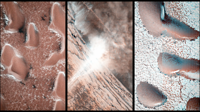
Alt...
It’s a new year on Mars, and while New Year’s means winter in Earth’s northern hemisphere, it’s the start of spring in the same region of the Red Planet. And that means ice is thawing, leading to all sorts of interesting things. JPL research scientist Serina Diniega explains. NASA/JPL-Caltech
2025 July 6
The Spiral North Pole of Mars
* Image Credit: ESA/DLR/FU Berlin; NASA MGS MOLA Science Team
http://www.esa.int/
http://www.dlr.de/pf/
http://www.fu-berlin.de/
https://www.nasa.gov/
https://mars.nasa.gov/programmissions/missions/past/globalsurveyor/
https://attic.gsfc.nasa.gov/mola/
Explanation:
Why is there a spiral around the North Pole of Mars? Each winter this pole develops a new outer layer about one meter thick composed of carbon dioxide frozen out of the thin Martian atmosphere. This fresh layer is deposited on a water-ice layer that exists year round. Strong winds blow down from above the cap's center and swirl due to the spin of the red planet -- contributing to Planum Boreum's spiral structure. The featured image is a perspective mosaic generated in 2017 from numerous images taken by ESA's Mars Express and elevations extracted from the laser altimeter aboard NASA's Mars Global Surveyor mission.
https://www.esa.int/ESA_Multimedia/Images/2017/02/Perspective_view_of_Mars_north_polar_ice_cap
!>>https://ilrs.gsfc.nasa.gov/lw16/docs/presentations/sci_6_Smith.pdf
https://en.wikipedia.org/wiki/Planum_Boreum
https://en.wikipedia.org/wiki/Katabatic_wind
https://apod.nasa.gov/apod/ap250706.html
#space #mars #astrophotography #photography #science #astronomy #geology #nature #NASA
 & Jerry Bonnell (UMCP)
NASA Official: Amber Straughn Specific rights apply.
NASA Web Privacy, Accessibility, Notices;
A service of: ASD at NASA / GSFC,
NASA Science Activation
& Michigan Tech. U.")
Alt...
2025 July 6
A computer construction of what the north pole of Mars looks like. The picture was constructed from measured altitude data. A spiral landscape is seen that is colored red but is mostly covered with white ice.
The Spiral North Pole of Mars
* Image Credit: ESA/DLR/FU Berlin; NASA MGS MOLA Science Team
Explanation:
Why is there a spiral around the North Pole of Mars? Each winter this pole develops a new outer layer about one meter thick composed of carbon dioxide frozen out of the thin Martian atmosphere. This fresh layer is deposited on a water-ice layer that exists year round. Strong winds blow down from above the cap's center and swirl due to the spin of the red planet -- contributing to Planum Boreum's spiral structure. The featured image is a perspective mosaic generated in 2017 from numerous images taken by ESA's Mars Express and elevations extracted from the laser altimeter aboard NASA's Mars Global Surveyor mission.
Authors & editors: Robert Nemiroff (MTU) & Jerry Bonnell (UMCP)
NASA Official: Amber Straughn Specific rights apply.
NASA Web Privacy, Accessibility, Notices;
A service of: ASD at NASA / GSFC,
NASA Science Activation
& Michigan Tech. U.
"27 years ago, the first 3D visualizations of the North Pole of Mars were published and if you take into account the technical possibilities at that time and the resulting state of knowledge, then this image was a world sensation"
December 16, 1998
3-D Mars' North Pole
* Credit: MOLA Team, MGS Project, NASA
* Image: Greg Shirah (SVS)
Explanation:
This dramatic premier three-dimensional visualization of Mars' north pole is based on elevation measurements made by an orbiting laser. During the Spring and Summer of 1998 the Mars Orbiter Laser Altimeter (MOLA) flashed laser pulses toward the Martian surface from the Global Surveyor spacecraft and recorded the time it took to detect the reflection. This timing data has now been translated to a detailed topographic map of Mars' north polar terrain. The map indicates that the ice cap is is about 1,200 kilometers across, a maximum of 3 kilometers thick, and cut by canyons and troughs up to 1 kilometer deep. The measurements also indicate that the cap is composed primarily of water ice with a total volume of only about four percent of planet Earth's Antarctic ice sheet. In all it represents at most a tenth of the amount of water some scientists believe once existed on ancient Mars. Where did all the water go?
https://ilrs.gsfc.nasa.gov/lw16/docs/presentations/sci_6_Smith.pdf
https://apod.nasa.gov/apod/ap981216.html
#space #mars #astrophotography #photography #science #astronomy #geology #history #nature #NASA

Explanation:
This dramatic premier three-dimensional visualization of Mars' north pole is based on elevation measurements made by an orbiting laser. During the Spring and Summer of 1998 the Mars Orbiter Laser Altimeter (MOLA) flashed laser pulses toward the Martian surface from the Global Surveyor spacecraft and recorded the time it took to detect the reflection. This timing data has now been translated to a detailed topographic map of Mars' north polar terrain. The map indicates that the ice cap is is about 1,200 kilometers across, a maximum of 3 kilometers thick, and cut by canyons and troughs up to 1 kilometer deep. The measurements also indicate that the cap is composed primarily of water ice with a total volume of only about four percent of planet Earth's Antarctic ice sheet. In all it represents at most a tenth of the amount of water some scientists believe once existed on ancient Mars. Where did all the water go?
Authors & editors: Robert Nemiroff (MTU) & Jerry Bonnell (USRA)
NASA Technical Rep.: Jay Norris. Specific rights apply.
A service of: LHEA at NASA/ GSFC
&: Michigan Tech. U.")
Alt...
December 16, 1998
3-D Mars' North Pole
* Credit: MOLA Team, MGS Project, NASA
* Image: Greg Shirah (SVS)
Explanation:
This dramatic premier three-dimensional visualization of Mars' north pole is based on elevation measurements made by an orbiting laser. During the Spring and Summer of 1998 the Mars Orbiter Laser Altimeter (MOLA) flashed laser pulses toward the Martian surface from the Global Surveyor spacecraft and recorded the time it took to detect the reflection. This timing data has now been translated to a detailed topographic map of Mars' north polar terrain. The map indicates that the ice cap is is about 1,200 kilometers across, a maximum of 3 kilometers thick, and cut by canyons and troughs up to 1 kilometer deep. The measurements also indicate that the cap is composed primarily of water ice with a total volume of only about four percent of planet Earth's Antarctic ice sheet. In all it represents at most a tenth of the amount of water some scientists believe once existed on ancient Mars. Where did all the water go?
Authors & editors: Robert Nemiroff (MTU) & Jerry Bonnell (USRA)
NASA Technical Rep.: Jay Norris. Specific rights apply.
A service of: LHEA at NASA/ GSFC
&: Michigan Tech. U.
Some laser-based toporaphic views of the surface of Mars
#space #mars #astrophotography #photography #science #astronomy #geology #topography #nature #NASA
")
Alt...
This is a Global topographic map of Mars with major surface features labeled. (Credit: MOLA Science Team)
. These maps are orthographic projections that contain over 200,000,000 points and about 5,000,000 altimetric crossovers. The spatial resolution is about 15 kilometers at the equator and less at higher latitudes. The vertical accuracy is less than 5 meters.")
Alt...
Global false-color topographic views of Mars from the Mars Orbiter Laser Altimeter (MOLA). These maps are orthographic projections that contain over 200,000,000 points and about 5,000,000 altimetric crossovers. The spatial resolution is about 15 kilometers at the equator and less at higher latitudes. The vertical accuracy is less than 5 meters.
Cappuccino swirls at Mars’ south pole
This picture is, perhaps surprisingly, from ESA’s Mars Express, which has been exploring and imaging the martian surface and atmosphere since 2003. We may be used to seeing numerous images of red and brown-hued soil and ruddy landscapes peppered with craters, but the Red Planet isn’t always so red.
The bright white region of this image shows the icy cap that covers Mars’ south pole, composed of frozen water and carbon dioxide. While it looks smooth in this image, at close quarters the cap is a layered mix of peaks, troughs and flat plains, and has been likened in appearance to swiss cheese.
The southern cap reaches some 3 km thick in places, and is around 350 km in diameter. This icy region is permanent; in the martian winter another, thinner ice cap forms over the top of it, stretching further out across the planet and disappearing again when the weather warms up.
The cap is around 150 km north of Mars’ geographical south pole and Mars Express has shed light on why this ice cap is displaced. Deep impact craters – notably the Hellas Basin, the largest impact structure on the entire planet at 7 km deep and 2300 km across – funnel the strong winds that blow across Mars towards its southern pole, creating a mix of different low- and high-pressure systems. The carbon dioxide in the polar cap sublimates at different rates in these regions with contrasting pressure, resulting in the cap’s lopsided structure.
Mars Express imaged this area of Mars on 17 December 2012, in infrared, green and blue light, using its High Resolution Stereo Camera. This image was processed by Bill Dunford, using data available from the ESA Planetary Science Archive.
CREDIT
ESA/DLR/FU Berlin / Bill Dunford
#space #mars #astrophotography #photography #science #astronomy #geology #topography #nature #NASA

Alt...
Swirls of chocolate, caramel and cream – this image is definitely one to trigger sweet-toothed cravings. Smooth cream-coloured plateaus surrounded by cocoa-dusted ridges interspersed with caramel-hued streaks create a scene reminiscent of a cosmic cappuccino.
This picture is, perhaps surprisingly, from ESA’s Mars Express, which has been exploring and imaging the martian surface and atmosphere since 2003. We may be used to seeing numerous images of red and brown-hued soil and ruddy landscapes peppered with craters, but the Red Planet isn’t always so red.
CREDIT
ESA/DLR/FU Berlin / Bill Dunford
Upper surface of icy layers covering Mars' south-polar region
This map shows the topography of the south polar region of Mars. The data were collected by the Mars Orbiter Laser Altimeter (MOLA) aboard NASA’s Mars Global Surveyor orbiter between 1997 and 2001.
The elevation of the terrain is shown by colors, with purple and blue representing the lowest areas, and orange and red the highest. The total range of elevation shown is about 5 kilometres. The black line shows the boundary of the south polar layered deposits, an ice-rich geologic unit that was probed by the Mars Advanced Radar for Subsurface and Ionospheric Sounding (MARSIS) aboard the European Space Agency's Mars Express orbiter between 2005 and 2006.
The radar data indicate that the deposit is more than 3.7 kilometres thick in places, and that the material consists of nearly pure water ice, with only a small component of dust. The MARSIS team also determined that the total volume of ice in the layered deposits is equivalent to a water layer 11 metres deep, if spread evenly across the planet. The boundary of the layered deposits was mapped by scientists from the U.S. Geological Survey. The dark circle in the upper center is the area pole-ward of 87 ° south latitude, where MARSIS data cannot be collected. The image covers an area 1670 by 1800 kilometres.
CREDIT
NASA/MOLA Science Team
#space #mars #astrophotography #photography #science #astronomy #geology #topography #nature #NASA
 aboard NASA’s Mars Global Surveyor orbiter between 1997 and 2001.")
Alt...
This map shows the topography of the south polar region of Mars. The data were collected by the Mars Orbiter Laser Altimeter (MOLA) aboard NASA’s Mars Global Surveyor orbiter between 1997 and 2001.
Hebes Chasma, perspective view
Perspective view of Hebes Chasma obtained by the High Resolution Stereo Camera (HRSC) on ESA’s Mars Express spacecraft.
Hebes Chasma is located at approximately 1° south and 282° east. The HRSC obtained image data on 16 September 2005 with a ground resolution of approximately 15 m/pixel.
CREDIT
ESA/DLR/FU Berlin (G. Neukum)
#space #mars #astrophotography #photography #science #astronomy #geology #topography #nature #NASA
 on ESA’s Mars Express spacecraft.
Hebes Chasma is located at approximately 1° south and 282° east. The HRSC obtained image data on 16 September 2005 with a ground resolution of approximately 15 m/pixel.
CREDIT
ESA/DLR/FU Berlin (G. Neukum)")
Alt...
Hebes Chasma, perspective view
Perspective view of Hebes Chasma obtained by the High Resolution Stereo Camera (HRSC) on ESA’s Mars Express spacecraft.
Hebes Chasma is located at approximately 1° south and 282° east. The HRSC obtained image data on 16 September 2005 with a ground resolution of approximately 15 m/pixel.
CREDIT
ESA/DLR/FU Berlin (G. Neukum)
2017 May 28
Collapse in Hebes Chasma on Mars
* Image Credit & License: ESA/DLR/FU Berlin (G. Neukum)
http://www.esa.int/
http://www.dlr.de/pf/
http://www.fu-berlin.de/
https://www.esa.int/Science_Exploration/Space_Science/People/Man_with_a_plan_An_interview_with_Gerhard_Neukum
Explanation:
What's happened in Hebes Chasma on Mars? Hebes Chasma is a depression just north of the enormous Valles Marineris canyon. Since the depression is unconnected to other surface features, it is unclear where the internal material went. Inside Hebes Chasma is Hebes Mensa, a 5 kilometer high mesa that appears to have undergone an unusual partial collapse -- a collapse that might be providing clues. The featured image, taken by ESA's robotic Mars Express spacecraft currently orbiting Mars, shows great details of the chasm and the unusual horseshoe shaped indentation in the central mesa. Material from the mesa appears to have flowed onto the floor of the chasm, while a possible dark layer appears to have pooled like ink on a downslope landing. A recent hypothesis holds that salty rock composes some lower layers in Hebes Chasma, with the salt dissolving in melted ice flows that drained through holes into an underground aquifer.
https://en.wikipedia.org/wiki/Hebes_Chasma
!>>http://geomorphology.sese.asu.edu/Papers/Adams_etal_hebes_chasma_salt_tectonics_geol.pdf
https://en.wikipedia.org/wiki/Aquifer
https://apod.nasa.gov/apod/ap170528.html
#space #mars #astrophotography #photography #science #astronomy #geology #topography #nature #NASA

Explanation:
What's happened in Hebes Chasma on Mars? Hebes Chasma is a depression just north of the enormous Valles Marineris canyon. Since the depression is unconnected to other surface features, it is unclear where the internal material went. Inside Hebes Chasma is Hebes Mensa, a 5 kilometer high mesa that appears to have undergone an unusual partial collapse -- a collapse that might be providing clues. The featured image, taken by ESA's robotic Mars Express spacecraft currently orbiting Mars, shows great details of the chasm and the unusual horseshoe shaped indentation in the central mesa. Material from the mesa appears to have flowed onto the floor of the chasm, while a possible dark layer appears to have pooled like ink on a downslope landing. A recent hypothesis holds that salty rock composes some lower layers in Hebes Chasma, with the salt dissolving in melted ice flows that drained through holes into an underground aquifer.
Authors & editors: Robert Nemiroff (MTU) & Jerry Bonnell (UMCP)
NASA Official: Phillip Newman Specific rights apply.
NASA Web Privacy Policy and Important Notices
A service of: ASD at NASA / GSFC
& Michigan Tech. U.")
Alt...
2017 May 28
Collapse in Hebes Chasma on Mars
* Image Credit & License: ESA/DLR/FU Berlin (G. Neukum)
Explanation:
What's happened in Hebes Chasma on Mars? Hebes Chasma is a depression just north of the enormous Valles Marineris canyon. Since the depression is unconnected to other surface features, it is unclear where the internal material went. Inside Hebes Chasma is Hebes Mensa, a 5 kilometer high mesa that appears to have undergone an unusual partial collapse -- a collapse that might be providing clues. The featured image, taken by ESA's robotic Mars Express spacecraft currently orbiting Mars, shows great details of the chasm and the unusual horseshoe shaped indentation in the central mesa. Material from the mesa appears to have flowed onto the floor of the chasm, while a possible dark layer appears to have pooled like ink on a downslope landing. A recent hypothesis holds that salty rock composes some lower layers in Hebes Chasma, with the salt dissolving in melted ice flows that drained through holes into an underground aquifer.
Authors & editors: Robert Nemiroff (MTU) & Jerry Bonnell (UMCP)
NASA Official: Phillip Newman Specific rights apply.
NASA Web Privacy Policy and Important Notices
A service of: ASD at NASA / GSFC
& Michigan Tech. U.
From Wikipedia, the free encyclopedia
Hebes Chasma
is an isolated chasma just north of the Valles Marineris canyon system of Mars. It is centered at 1 degree southern latitude and 76 degrees western longitude, just between the Martian equator and the Valles Marineris system, just east of the Tharsis region.
Hebes Chasma is a completely closed depression in the surface of Mars, with no outflows to the nearby Echus Chasma to the west, Perrotin Crater to the southwest, or Valles Marineris to the south. Its maximum extents are approximately 320 km east to west, 130 km north to south, and 5 to 6 km in depth. At the center of the depression is Hebes Mensa, a large mesa rising some 5 km off the valley floor, nearly as high as the surrounding terrain. This central plateau makes Hebes Chasma a unique valley in Martian geography.
The word Hebes comes from Hebe, the goddess of youth, who was the daughter of Zeus and Hera. Hebe was the wife of Hercules.
The walls of Hebes Chasma weather differently than the slopes on the mesa on its floor. Also, studies of the thermal inertia suggest that the mesa and the walls of the canyon are made of different substances. Thermal inertia is how long the surface holds heat. For example, rocky areas will stay warmer than dust at night. One popular idea that explains the difference between the depression's walls and the mesa slopes is that the mesa was formed from material that accumulated in a lake.
https://en.wikipedia.org/wiki/Hebes_Chasma
#space #mars #astrophotography #photography #science #astronomy #geology #topography #nature #NASA
, 2149 (16 September 2005), 3217 (12 July 2006), 5142 (3 January 2008), 5160 (8 January 2008), 5178 (13 January 2008), 6241 (11 November 2008), and 7237 (24 August 2009). The image centre lies at about 1°S / 284°E. Hebes Chasma is an enclosed, almost 8 km-deep trough stretching 315 km in an east–west direction and 125 km from north to south at its widest point. It sits about 300 km north of the vast Valles Marineris canyon. A flat-topped mesa is located in the centre of Hebes Chasma, which was likely shaped by the action of wind and water.
CREDIT
ESA/DLR/FU Berlin (G. Neukum),CC BY-SA 3.0 IGO")
Alt...
This mosaic of Hebes Chasma is composed of eight single images taken with the High Resolution Stereo Camera on Mars Express, corresponding to orbits 360 (2 May 2004), 2149 (16 September 2005), 3217 (12 July 2006), 5142 (3 January 2008), 5160 (8 January 2008), 5178 (13 January 2008), 6241 (11 November 2008), and 7237 (24 August 2009). The image centre lies at about 1°S / 284°E. Hebes Chasma is an enclosed, almost 8 km-deep trough stretching 315 km in an east–west direction and 125 km from north to south at its widest point. It sits about 300 km north of the vast Valles Marineris canyon. A flat-topped mesa is located in the centre of Hebes Chasma, which was likely shaped by the action of wind and water.
CREDIT
ESA/DLR/FU Berlin (G. Neukum),CC BY-SA 3.0 IGO
 images from the 2001 Mars Odyssey orbiter mission. The small colored globe based on Mars Orbiter Laser Altimeter (MOLA).
CREDIT
NASA, modified by Chmee2")
Alt...
This product is an infrared image mosaic generated using Thermal Emission Imaging System (THEMIS) images from the 2001 Mars Odyssey orbiter mission. The small colored globe based on Mars Orbiter Laser Altimeter (MOLA).
CREDIT
NASA, modified by Chmee2
, with a portion of Ophir Chasma at lower right, and the southern part of Echus Chasma at upper left. Perrotin Crater is just left of lower center. This image was obtained by cropping a massive 23,711 × 11,856 pixel mosaic of NASA images, and adjusting in hue and saturation. The original caption for the mosaic reads in part as follows: This mosaic image of Valles Marineris - colored to resemble the martian surface - comes from the Thermal Emission Imaging System (THEMIS), a visible-light and infrared-sensing camera on NASA's Mars Odyssey orbiter. Mars Odyssey was built by Lockheed Martin and the mission is operated by the Jet Propulsion Laboratory. Built from more than 500 daytime infrared photos, the mosaic shows the whole valley in more detail than any previous composite photo. Despite the valley's huge extent - including its western extension through Noctis Labyrinthus, it reaches some 3,000 kilometers (2,000 miles) long - the smallest details visible in the image are about the size of a football field: 100 meters (328 feet).
CREDIT
NASA / JPL-Caltech / Arizona State University")
Alt...
View of most of Hebes Chasma (upper center and right), with a portion of Ophir Chasma at lower right, and the southern part of Echus Chasma at upper left. Perrotin Crater is just left of lower center. This image was obtained by cropping a massive 23,711 × 11,856 pixel mosaic of NASA images, and adjusting in hue and saturation. The original caption for the mosaic reads in part as follows: This mosaic image of Valles Marineris - colored to resemble the martian surface - comes from the Thermal Emission Imaging System (THEMIS), a visible-light and infrared-sensing camera on NASA's Mars Odyssey orbiter. Mars Odyssey was built by Lockheed Martin and the mission is operated by the Jet Propulsion Laboratory. Built from more than 500 daytime infrared photos, the mosaic shows the whole valley in more detail than any previous composite photo. Despite the valley's huge extent - including its western extension through Noctis Labyrinthus, it reaches some 3,000 kilometers (2,000 miles) long - the smallest details visible in the image are about the size of a football field: 100 meters (328 feet).
CREDIT
NASA / JPL-Caltech / Arizona State University
Alt...
Fly-through movie of Hebes Chasma, the northernmost part of Valles Marineris. (No Audio)
The movie was created from images taken by the High Resolution Stereo Camera on Mars Express and was first published by Freie Universität Berlin in 2008.
CREDIT
ESA/DLR/FU Berlin (G. Neukum)
2014 May 11
Valles Marineris: The Grand Canyon of Mars
* Image Credit: Viking Project, USGS, NASA
https://nssdc.gsfc.nasa.gov/planetary/viking.html
https://www.usgs.gov/
http://www.nasa.gov/
Explanation:
The largest canyon in the Solar System cuts a wide swath across the face of Mars. Named Valles Marineris, the grand valley extends over 3,000 kilometers long, spans as much as 600 kilometers across, and delves as much as 8 kilometers deep. By comparison, the Earth's Grand Canyon in Arizona, USA is 800 kilometers long, 30 kilometers across, and 1.8 kilometers deep. The origin of the Valles Marineris remains unknown, although a leading hypothesis holds that it started as a crack billions of years ago as the planet cooled. Several geologic processes have been identified in the canyon. This mosaic was created from over 100 images of Mars taken by Viking Orbiters in the 1970s.
https://en.wikipedia.org/wiki/Valles_Marineris
https://www.windows2universe.org/mars/interior/Valles_Marineris.html
https://nssdc.gsfc.nasa.gov/photo_gallery/photogallery-mars.html
https://science.nasa.gov/mars/facts/
https://apod.nasa.gov/apod/ap140511.html
https://apod.nasa.gov/apod/ap140511.html
#space #mars #astrophotography #photography #science #astronomy #geology #topography #nature #NASA
 & Jerry Bonnell (UMCP)
NASA Official: Phillip Newman Specific rights apply.
NASA Web Privacy Policy and Important Notices
A service of: ASD at NASA / GSFC
& Michigan Tech. U.")
Alt...
2014 May 11
Valles Marineris: The Grand Canyon of Mars
* Image Credit: Viking Project, USGS, NASA
Explanation:
The largest canyon in the Solar System cuts a wide swath across the face of Mars. Named Valles Marineris, the grand valley extends over 3,000 kilometers long, spans as much as 600 kilometers across, and delves as much as 8 kilometers deep. By comparison, the Earth's Grand Canyon in Arizona, USA is 800 kilometers long, 30 kilometers across, and 1.8 kilometers deep. The origin of the Valles Marineris remains unknown, although a leading hypothesis holds that it started as a crack billions of years ago as the planet cooled. Several geologic processes have been identified in the canyon. The above mosaic was created from over 100 images of Mars taken by Viking Orbiters in the 1970s.
Authors & editors: Robert Nemiroff (MTU) & Jerry Bonnell (UMCP)
NASA Official: Phillip Newman Specific rights apply.
NASA Web Privacy Policy and Important Notices
A service of: ASD at NASA / GSFC
& Michigan Tech. U.