Search results for tag #nature
![[?]](https://files.defcon.social/dcsocial-s3/accounts/avatars/113/208/344/507/078/943/original/014820ad22daee1c.jpg)
Comet C/2025 R2 (SWAN)
Below the horizon. Rise: 9:47 | Tran: 14:46 | Set: 19:44
Alt: -29.26° Az: 70.51° Direction: East-North-East
Comet C/2025 R2 (SWAN) is in the constellation of Virgo, at a distance of 117,117,474.3 kilometers from Earth. The current Right Ascension is 13h 35m 39s and the Declination is -11° 36’ 24” (apparent coordinates). The latest observed magnitude of comet C/2025 R2 (SWAN) is 7.3 (data provided by COBS).
* URL'S associated with the images:
1. to 2. https://theskylive.com/planetarium?obj=c2025r2
3. 5. 6. https://theskylive.com/c2025r2-tracker
4. https://theskylive.com/3dsolarsystem?obj=c2025r2
On this website you can follow the current data of the comet live:
https://theskylive.com/c2025r2-info
CREDIT
TheSkyLive.com
----
From Wikipedia, the free encyclopedia:
C/2025 R2 (SWAN)
C/2025 R2 (SWAN), formerly known as SWAN25B, is a non-periodic comet discovered on 11 September 2025 by Vladimir Bezugly through SWAN imagery. As of 17 September 2025, the comet has an apparent magnitude of +6.9 with a solar elongation of 30 degrees and is observable near the star Spica in 50 mm (2.0 in) binoculars. It is better seen from the Southern hemisphere.
Observational history
The comet was first spotted in images from the SWAN instrument onboard the Solar and Heliospheric Observatory (SOHO) by amateur astronomer Vladimir Bezugly on 11 September 2025. The presence of the comet was confirmed by other amateur astronomers, having an estimated magnitude of 7.4 and featuring a tail about 2 degrees long. The comet upon discovery was located in the constellation of Virgo and it was better seen from the southern hemisphere as it was higher in the sky after sunset.
[...]
Please read more in next post.
Text Credits:
Contributors to Wikimedia projects
#space #comets #astrophotography #photography #science #astronomy #nature #NASA #ESA #education
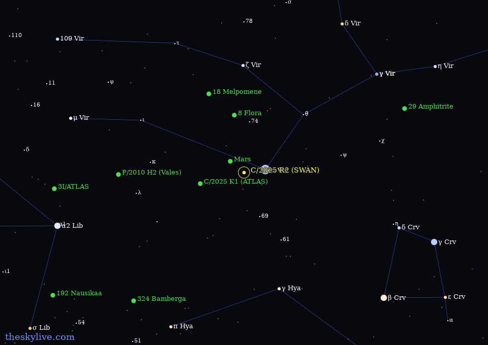
Alt...
Star map showing the position of comet C/2025 R2 (SWAN) in the constellation of Virgo on September 18, 2025. Field of view: 50x30 degrees.
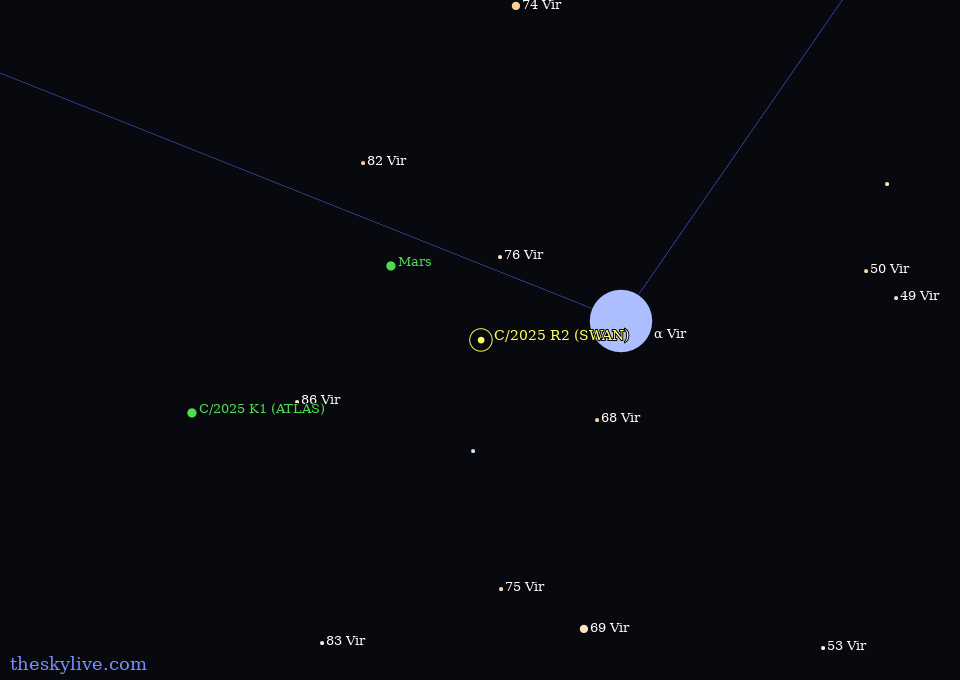
Alt...
Star map showing the position of comet C/2025 R2 (SWAN) in the constellation of Virgo on September 18, 2025. Field of view: 15x9 degrees.
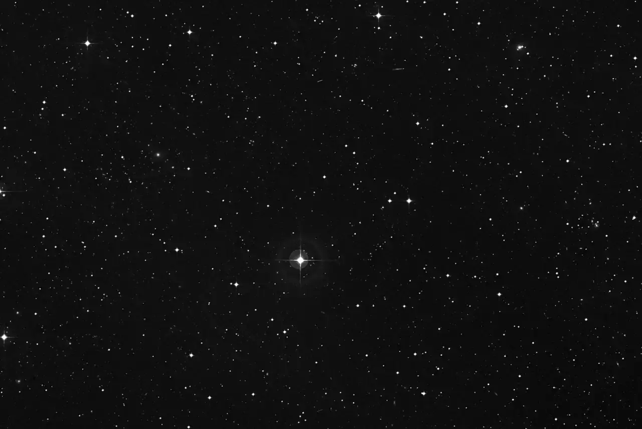
Alt...
Simplified high-resolution deep sky chart showing the current position of comet C/2025 R2 (SWAN). Field of view: 60 x 40 arcminutes.
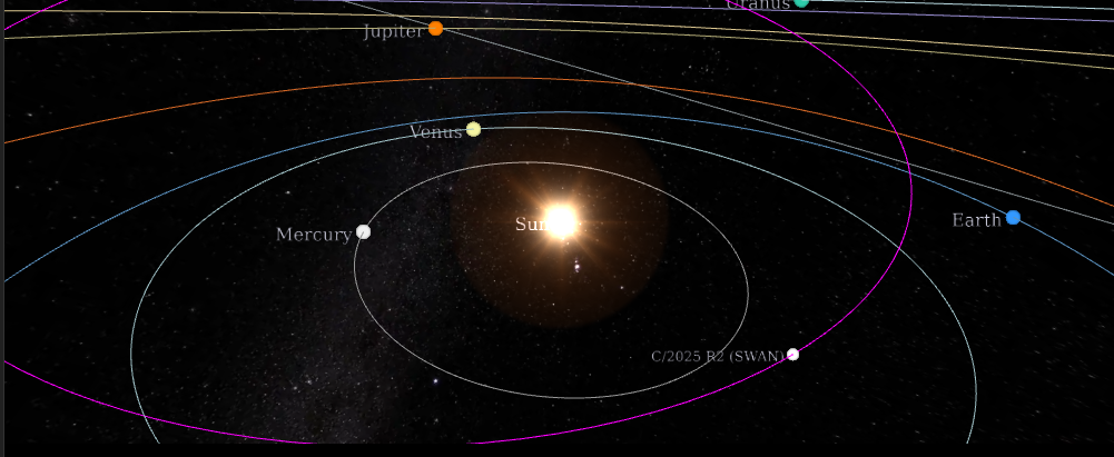
Alt...
3D animated visualization of the orbit of comet C/2025 R2 (SWAN) relative to the other major objects in the Solar System.
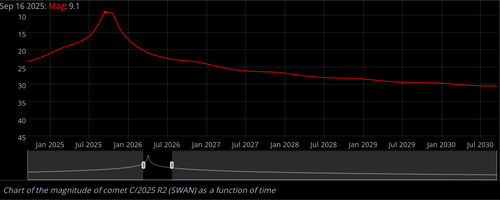
Alt...
Light curve of comet C/2025 R2 (SWAN), i.e., its apparent magnitude as a function of time. The curve is calculated using the latest ephemerides provided by JPL Horizons. The magnitude data is sampled with the interval of 2 days. Because of this sampling, inaccuracies may occur for objects that have large variations of brightness over a few days. For comets, large discrepancies can arise between the calculated brightness and the observations due to their highly dynamic, and not always precisely predictable, behavior.
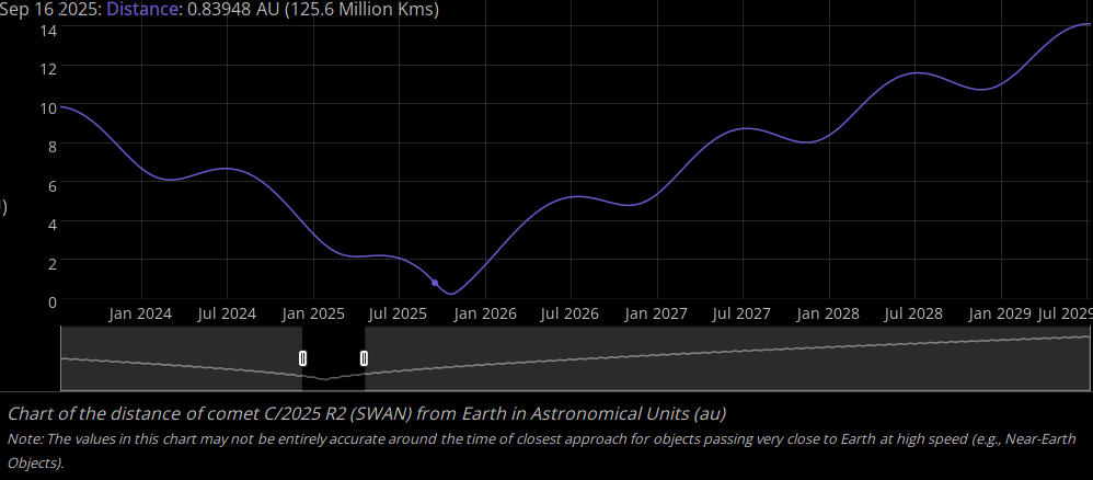
Alt...
Distance of comet C/2025 R2 (SWAN) from Earth as a function of time. In the chart the distance is measured in Astronomical Units and the data is sampled with an interval of 1 day.
https://theskylive.com/3dsolarsystem?obj=c2025r2
Interactive 3D Orbit Visualization
#space #comets #astrophotography #photography #science #astronomy #nature #NASA #ESA #education
2025 September 18
Comet C/2025 R2 (SWAN)
* Image Credit & Copyright: Team Ciel Austral
https://www.cielaustral.com/
Explanation:
A new visitor from the outer Solar System, comet C/2025 R2 (SWAN) also known as SWAN25B was only discovered late last week, on September 11. That's just day before the comet reached perihelion, its closest approach to the Sun. First spotted by Vladimir Bezugly in images from the SWAN instrument on the sun-staring SOHO spacecraft, the comet was surprisingly bright but understandably difficult to see against the Sun's glare. Still close to the Sun on the sky, the greenish coma and tail of C/2025 R2 (SWAN) are captured in this telescopic snapshot from September 17. Spica, alpha star of the constellation Virgo, shines just beyond the upper left edge of the frame while the comet is about 6.5 light-minutes from planet Earth. Near the western horizon after sunset and slightly easier to see in binoculars from the southern hemisphere, this comet SWAN will pass near Zubenelgenubi, alpha star of Libra, on October 2. C/2025 R2 (SWAN) is scheduled to make its closest approach to our fair planet around October 20.
https://app.astrobin.com/i/i5qsgj
https://earthsky.org/space/new-comet-swan25b-2025/
https://cobs.si/obs_list?id=2659
https://en.wikipedia.org/wiki/C/2025_R2_(SWAN)#Observational_history
https://spaceplace.nasa.gov/comets/en/
https://science.nasa.gov/mission/soho/
https://apod.nasa.gov/apod/ap250918.html
#space #comets #astrophotography #photography #science #astronomy #nature #NASA #ESA #education
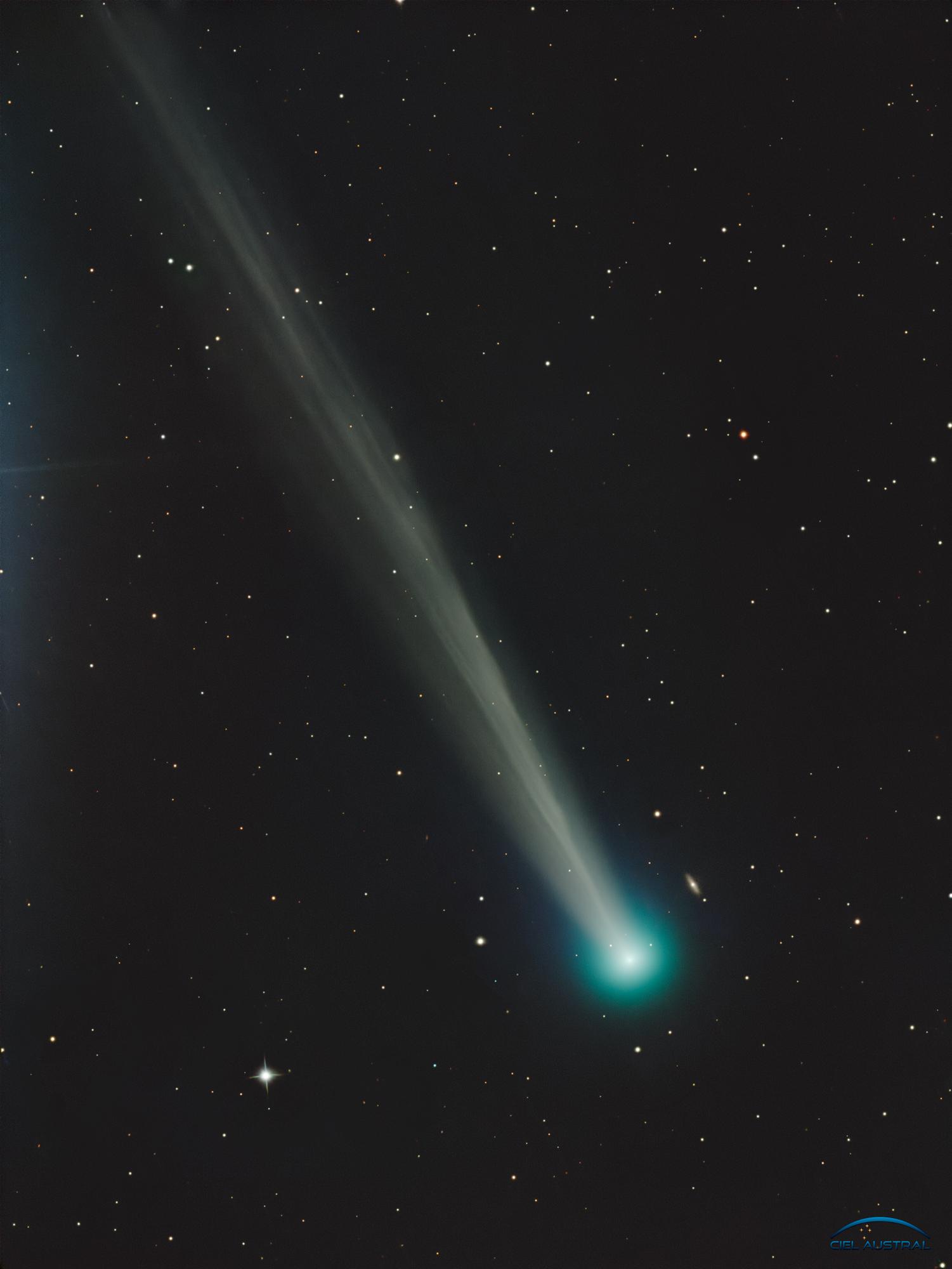
Alt...
2025 September 18
Comet C/2025 R2 (SWAN)
* Image Credit & Copyright: Team Ciel Austral
Explanation:
A new visitor from the outer Solar System, comet C/2025 R2 (SWAN) also known as SWAN25B was only discovered late last week, on September 11. That's just day before the comet reached perihelion, its closest approach to the Sun. First spotted by Vladimir Bezugly in images from the SWAN instrument on the sun-staring SOHO spacecraft, the comet was surprisingly bright but understandably difficult to see against the Sun's glare. Still close to the Sun on the sky, the greenish coma and tail of C/2025 R2 (SWAN) are captured in this telescopic snapshot from September 17. Spica, alpha star of the constellation Virgo, shines just beyond the upper left edge of the frame while the comet is about 6.5 light-minutes from planet Earth. Near the western horizon after sunset and slightly easier to see in binoculars from the southern hemisphere, this comet SWAN will pass near Zubenelgenubi, alpha star of Libra, on October 2. C/2025 R2 (SWAN) is scheduled to make its closest approach to our fair planet around October 20.
Authors & editors: Robert Nemiroff (MTU) & Jerry Bonnell (UMCP)
NASA Official: Amber Straughn Specific rights apply.
NASA Web Privacy, Accessibility, Notices;
A service of: ASD at NASA / GSFC,
NASA Science Activation
& Michigan Tech. U.
![[?]](https://cdn.masto.host/mastodonart/accounts/avatars/107/457/830/354/834/135/original/48254bba15a075c1.jpg)
Attn: bird lovers! The winners of the 2025 Audubon Photography Awards are here 🐦 🦢 🦉
https://www.thisiscolossal.com/2025/09/2025-audubon-photography-awards-birds-conservation-migration/

Alt...
a Brandt's cormorant spreads its wings, with seaweed and algae in its mouth

Alt...
a woodpecker pecks at a dead tree, with numerous other holes already pecked, filled with acorns
![[?]](https://static.toot.community/accounts/avatars/109/427/564/707/119/732/original/8e9e9a40fe4d6e67.jpg)

2025 September 15
Earth During a Powerful Solar Storm
* Video Credit: NASA's SVS, SWRC, CCMC, SWMF; T. Bridgman et al.
https://www.nasa.gov/
https://svs.gsfc.nasa.gov/
https://science.gsfc.nasa.gov/heliophysics/spaceweather
https://ccmc.gsfc.nasa.gov/
https://clasp.engin.umich.edu/research/theory-computational-methods/space-weather-modeling-framework/
https://svs.gsfc.nasa.gov/search/?people=Tom%20Bridgman
https://svs.gsfc.nasa.gov/4189/
Explanation:
Can our Sun become dangerous? Yes, sometimes. Every few years our Sun ejects a scary-large bubble of hot gas into the Solar System. Every hundred years or so, when the timing, location, and magnetic field connections are just right, such a Coronal Mass Ejection (CME) will hit the Earth. When this happens, the Earth not only experiences dramatic auroras, but its magnetic field gets quickly pushed back and compressed, which causes electric grids to surge. Some of these surges could be dangerous, affecting satellites and knocking out power grids -- which can take months to fix. Just such a storm -- called the Carrington Event -- occurred in 1859 and caused telegraph wires to spark. A similar CME passed near the Earth in 2012, and the featured animated video shows a computer model of what might have happened if it had been a direct hit. In this model, the Earth's magnetopause becomes so compressed that it went inside the orbit of geosynchronous communication satellites.
https://apod.nasa.gov/apod/ap250915.html
#space #sun #astrophotography #photography #science #astronomy #physics #nature #NASA
TOPIC> Our Sun
2025 July 30
Four images of the Sun's edge are shown. In each a loop of bright material is captured above the Sun's surface.
Coronal Loops on the Sun
* Image Credit & Copyright: Andrea Vanoni
https://andreavanoni.wixsite.com/astrophotography/su-di-me
Explanation:
Our Sun frequently erupts in loops. Hot solar plasma jumps off the Sun's surface into prominences, with the most common type of prominence being a simple loop. The loop shape originates from the Sun's magnetic field, which is traced by spiraling electrons and protons. Many loops into the Sun's lower corona are large enough to envelop the Earth and are stable enough to last days. They commonly occur near active regions that also include dark sunspots. The featured panel shows four loops, each of which was captured near the Sun's edge during 2024 and 2025. The images were taken by a personal telescope in Mantova, Italy and in a very specific color of light emitted primarily by hydrogen. Some solar prominences suddenly break open and eject particles into the Solar System, setting up a space weather sequence that can affect the skies and wires of Earth.
https://science.nasa.gov/sun/
https://science.nasa.gov/solar-system/
SpacePlace:
https://spaceplace.nasa.gov/all-about-the-sun/en/
https://youtu.be/2g1epPppIOM
https://spaceplace.nasa.gov/spaceweather/en/
https://apod.nasa.gov/apod/ap250730.html
#space #sun #astrophotography #photography #science #astronomy #physics #nature #NASA
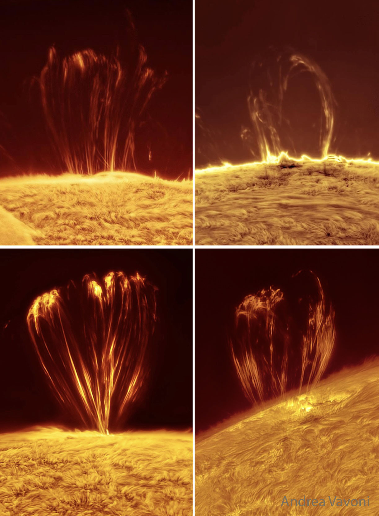
Alt...
2025 July 30
Four images of the Sun's edge are shown. In each a loop of bright material is captured above the Sun's surface.
Coronal Loops on the Sun
* Image Credit & Copyright: Andrea Vanoni
Explanation:
Our Sun frequently erupts in loops. Hot solar plasma jumps off the Sun's surface into prominences, with the most common type of prominence being a simple loop. The loop shape originates from the Sun's magnetic field, which is traced by spiraling electrons and protons. Many loops into the Sun's lower corona are large enough to envelop the Earth and are stable enough to last days. They commonly occur near active regions that also include dark sunspots. The featured panel shows four loops, each of which was captured near the Sun's edge during 2024 and 2025. The images were taken by a personal telescope in Mantova, Italy and in a very specific color of light emitted primarily by hydrogen. Some solar prominences suddenly break open and eject particles into the Solar System, setting up a space weather sequence that can affect the skies and wires of Earth.
Authors & editors: Robert Nemiroff (MTU) & Jerry Bonnell (UMCP)
NASA Official: Amber Straughn Specific rights apply.
NASA Web Privacy, Accessibility, Notices;
A service of: ASD at NASA / GSFC,
NASA Science Activation
& Michigan Tech. U.
2024 August 18
A Solar Prominence Eruption from SDO
* Image Credit: NASA/Goddard/SDO AIA Team
https://www.nasa.gov/
https://www.nasa.gov/goddard
https://sdo.gsfc.nasa.gov/
Explanation:
One of the most spectacular solar sights is an erupting prominence. In 2011, NASA's Sun-orbiting Solar Dynamic Observatory spacecraft imaged an impressively large prominence erupting from the surface. The dramatic explosion was captured in ultraviolet light in the featured time lapse video covering 90 minutes, where a new frame was taken every 24 seconds. The scale of the prominence is huge -- the entire Earth would easily fit under the flowing curtain of hot gas. A solar prominence is channeled and sometimes held above the Sun's surface by the Sun's magnetic field. A quiescent prominence typically lasts about a month and may erupt in a Coronal Mass Ejection (CME) expelling hot gas into the Solar System. The energy mechanism that creates a solar prominence is a continuing topic of research. Our Sun is again near solar maximum and so very active, featuring numerous erupting prominences and CMEs, one of which resulted in picturesque auroras just over the past week.
TOPIC> Auroras
https://defcon.social/@grobi/114646611195811889
https://apod.nasa.gov/apod/ap240818.html
#space #sun #astrophotography #photography #science #astronomy #physics #nature #NASA
Released Thursday, July 10, 2025
The Closest Images Ever Taken of the Sun’s Atmosphere
On its record-breaking pass by the Sun in December 2024, NASA’s Parker Solar Probe captured stunning new images from within the Sun’s atmosphere. These newly released images — taken closer to the Sun than we’ve ever been before — are helping scientists better understand the Sun’s influence across the solar system, including events that can affect Earth.
Parker Solar Probe started its closest approach to the Sun on Dec. 24, 2024, flying just 3.8 million miles from the solar surface. As it skimmed through the Sun’s outer atmosphere, called the corona, in the days around the perihelion, it collected data with an array of scientific instruments, including the Wide-Field Imager for Solar Probe, or WISPR.
Learn more - https://science.nasa.gov/science-research/heliophysics/nasas-parker-solar-probe-snaps-closest-ever-images-to-sun/
Credits:
NASA's Goddard Space Flight Center
NASA Scientific Visualization Studio
#space #sun #astrophotography #photography #science #astronomy #physics #nature #NASA

Alt...
Released Thursday, July 10, 2025
The Closest Images Ever Taken of the Sun’s Atmosphere
On its record-breaking pass by the Sun in December 2024, NASA’s Parker Solar Probe captured stunning new images from within the Sun’s atmosphere. These newly released images — taken closer to the Sun than we’ve ever been before — are helping scientists better understand the Sun’s influence across the solar system, including events that can affect Earth.
Parker Solar Probe started its closest approach to the Sun on Dec. 24, 2024, flying just 3.8 million miles from the solar surface. As it skimmed through the Sun’s outer atmosphere, called the corona, in the days around the perihelion, it collected data with an array of scientific instruments, including the Wide-Field Imager for Solar Probe, or WISPR.
Learn more - https://science.nasa.gov/science-research/heliophysics/nasas-parker-solar-probe-snaps-closest-ever-images-to-sun/
Credits:
NASA's Goddard Space Flight Center
NASA Scientific Visualization Studio
2025 August 11
Closest Ever Images Near the Sun
* Video Credit: NASA, JHUAPL, Naval Research Lab, Parker Solar Probe
https://www.nasa.gov/
https://www.jhuapl.edu/
https://www.nrl.navy.mil/
https://www.nasa.gov/content/goddard/parker-solar-probe
Explanation:
Everybody sees the Sun. Nobody's been there. Starting in 2018, though, NASA launched the robotic Parker Solar Probe (PSP) to investigate regions near to the Sun for the first time. The featured time-lapse video shows the view looking sideways from behind PSP's Sun shield in December during the closest approach of any human-made spacecraft to the Sun, looping down to only about five solar diameters above the Sun's hot surface. The PSP's Wide Field Imager for Solar Probe (WISPR) cameras took these images over seven hours, but they are digitally compressed here into about 5 seconds. The solar corona, including colliding coronal mass ejections (CMEs), is visible here in unprecedented detail, with stars passing far in the background. The Sun is not only Earth's dominant energy source, but its variable solar wind also compresses Earth's atmosphere, triggers auroras, affects power grids, and can even damage orbiting communication satellites.
https://svs.gsfc.nasa.gov/14865
https://parkersolarprobe.jhuapl.edu/
https://apod.nasa.gov/apod/ap180815.html
https://www.nature.com/articles/d41586-019-03665-3
https://science.nasa.gov/science-research/heliophysics/nasas-parker-solar-probe-snaps-closest-ever-images-to-sun/
https://en.wikipedia.org/wiki/Parker_Solar_Probe#Timeline
https://www.nasa.gov/image-article/what-coronal-mass-ejection-or-cme/
https://apod.nasa.gov/apod/ap000318.html
https://hesperia.gsfc.nasa.gov/rhessi3/mission/science/the-impact-of-flares/index.html
https://apod.nasa.gov/apod/ap250811.html
#space #sun #astrophotography #photography #science #astronomy #physics #nature #NASA
This animation shows all L3 WISPR full-field observations from the twenty-first PSP Mission Encounter (2024-09-25 - 2024-10-05). We have superimposed a grid showing helioprojective longitude and latitude, and a scale representation of the size and location of the Sun in the observations using the SDO/HMI Carrington map for this time period. The velocity and distance metrics displayed on the movies correspond respectively to the spacecraft's heliocentric velocity in kilometers per second, and its distance from the Sun's center in units of solar radii (where 1 solar radius = 695,700km). The "FOV Range" label provides the plane-of-sky distance limits of the inner and outermost edges of the fields of view, in units of solar radii. The horizontal blue line indicates the orbital plane of PSP. The timespan of this composite movie covers only the nominal science window when the spacecraft was within 0.25 au; a limited amount of data outside of this range may be available at the below links.
You can download this movie directly as an 101MB mp4 file. This sequence is also available as data processed via the LW Algorithm developed by Dr. Guillermo Stenborg (JHUAPL) and detailed in Appendix A of Howard et al. 2022 (ApJ, 936, id.43. DOI 10.3847/1538-4357/ac7ff5). Please contact the team for access to this data, which will be posted here one year after the acquisition of those observations. Team contact information can be found in Section 1.2 of the WISPR User's Guide
** https://wispr.nrl.navy.mil/sites/wispr.nrl.navy.mil/files/wispr_data_user_guide_v3.pdf [PDF link].
Credit:
* NASA/NRL/JHUAPL.
* Movie processed/compiled by Guillermo Stenborg (JHUAPL) and Karl Battams (NRL).
* SDO inset courtesy of NASA/SDO and the AIA, EVE, and HMI science teams.
/*grobi: this is a compressed and converted video-file for a better resolution go to:
** https://wispr.nrl.navy.mil/encounter21-summary (but that's a huge file !:D )
** the servers could be temporarily under maintenance
#space #sun #parker #astrophotography #photography #science #astronomy #physics #nature #NASA
2025 August 26
A Leaky Solar Prominence
Video Credit & Copyright: Andrea Girones
https://andreagirones.com/
Explanation:
What's hovering above the Sun? A solar prominence. A prominence is a crest of hot gas expelled from the Sun's surface that is held aloft by the Sun's magnetic field. Prominences can last for days, can suddenly explode into space, or just fall back to the Sun. What decides a prominence's fate is how the Sun's complex magnetic field changes -- the field's direction can act like an offramp for trapped solar particles. The 3-second (repeating) time-lapse featured video was captured earlier this month from Ottawa, Ontario, Canada. It shows the development of a larger-than-Earth prominence as it appears to leak solar plasma back to the Sun, over the course of an hour. What is unusual is that the prominence appears to hover -- more simple and typical prominences form magnetic loops that connect back to the surface. Many hours after this video ended, the hovering prominence disintegrated back into the Sun.
https://www.nasa.gov/image-article/what-solar-prominence/
https://solarscience.msfc.nasa.gov/the_key.shtml
https://apod.nasa.gov/apod/ap250826.html
#space #sun #astrophotography #photography #science #astronomy #physics #nature #NASA
2025 September 13
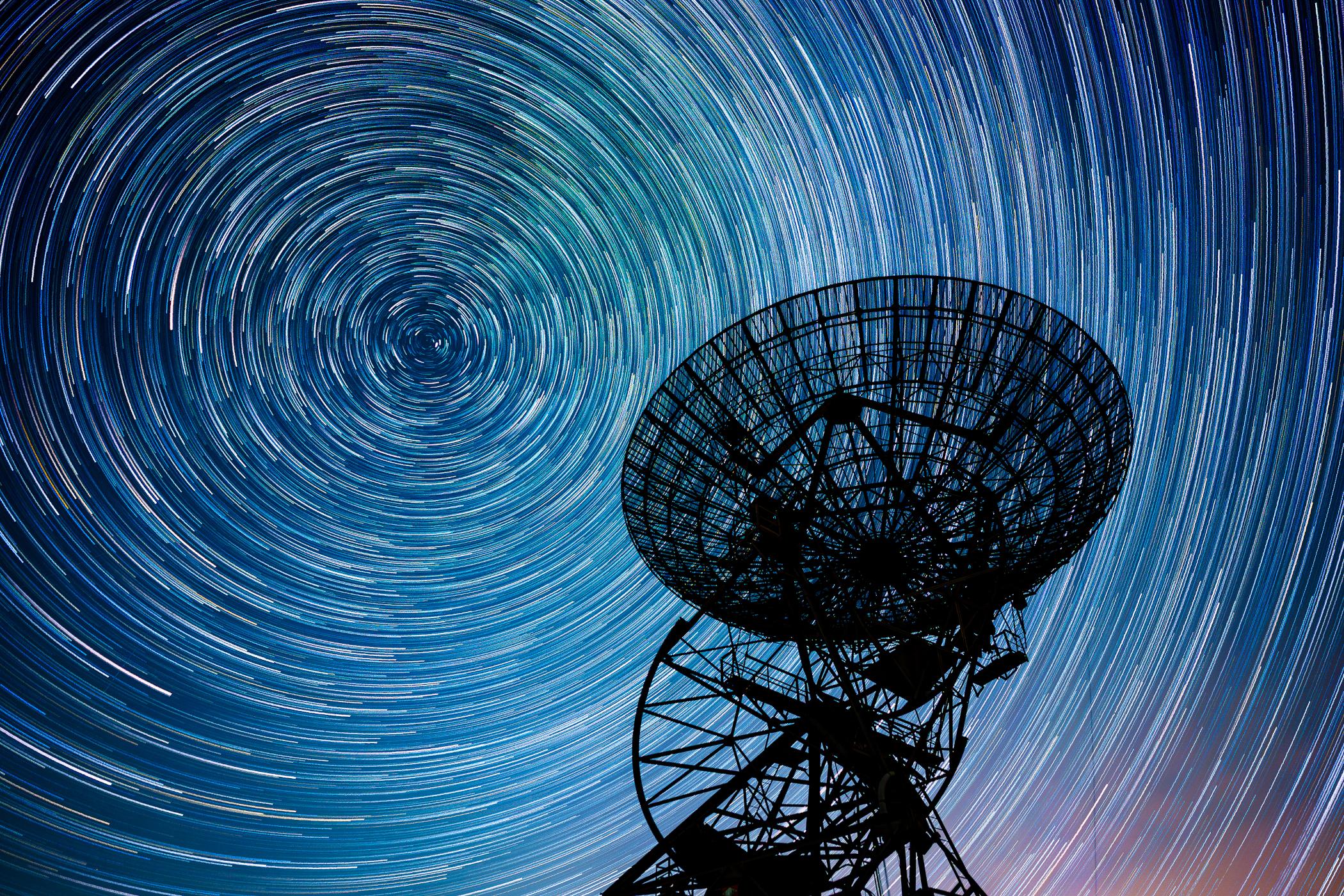
Star Trails over One-Mile Radio Telescope
* Image Credit & Copyright: Joao Yordanov Serralheiro
https://www.joaoysphotography.com/about
Explanation:
The steerable 60 foot diameter dish antenna of the One-Mile Telescope at Mullard Radio Astronomy Observatory, Cambridge, UK, is pointing skyward in this evocative night-skyscape. To capture the dramatic scene, consecutive 30 second exposures were recorded over a period of 90 minutes. Combined, the exposures reveal a background of gracefully arcing star trails that reflect planet Earth's daily rotation on its axis. The North Celestial Pole, the extension of Earth's axis of rotation into space, points near Polaris, the North Star. That's the bright star that creates the short trail near the center of the concentric arcs. But the historic One-Mile Telescope array also relied on planet Earth's rotation to operate. Exploring the universe at radio wavelengths, it was the first radio telescope to use Earth-rotation aperture synthesis. That technique uses the rotation of the Earth to change the relative orientation of the telescope array and celestial radio sources to create radio maps of the sky at a resolution better than that of the human eye.
https://apod.nasa.gov/apod/ap250913.html
#space #earth #astrophotography #photography #astroart #science #nature
Alt...
2025 September 13
Star Trails over One-Mile Radio Telescope
* Image Credit & Copyright: Joao Yordanov Serralheiro
Explanation:
The steerable 60 foot diameter dish antenna of the One-Mile Telescope at Mullard Radio Astronomy Observatory, Cambridge, UK, is pointing skyward in this evocative night-skyscape. To capture the dramatic scene, consecutive 30 second exposures were recorded over a period of 90 minutes. Combined, the exposures reveal a background of gracefully arcing star trails that reflect planet Earth's daily rotation on its axis. The North Celestial Pole, the extension of Earth's axis of rotation into space, points near Polaris, the North Star. That's the bright star that creates the short trail near the center of the concentric arcs. But the historic One-Mile Telescope array also relied on planet Earth's rotation to operate. Exploring the universe at radio wavelengths, it was the first radio telescope to use Earth-rotation aperture synthesis. That technique uses the rotation of the Earth to change the relative orientation of the telescope array and celestial radio sources to create radio maps of the sky at a resolution better than that of the human eye.
Authors & editors: Robert Nemiroff (MTU) & Jerry Bonnell (UMCP)
NASA Official: Amber Straughn Specific rights apply.
NASA Web Privacy, Accessibility, Notices;
A service of: ASD at NASA / GSFC,
NASA Science Activation
Cosmos in Reflection
* Image Credit & Copyright: Jeff Dai (TWAN)
https://twanight.org/profile/jeff-dai/
Explanation:
During the day, over 12,000 large mirrors reflect sunlight at the 100-megawatt, molten-salt, solar thermal power plant at the western edge of the Gobi desert near Dunhuang, Gansu Province, China. Individual mirror panels turn to track the sun like sunflowers. They conspire to act as a single super mirror reflecting the sunlight toward a fixed position, the power station's central tower. During the night the mirrors stand motionless though. They reflect the light of the countless distant stars, clusters and nebulae of the Milky Way and beyond. This sci-fi night skyscape was created with a camera fixed to a tripod near the edge of the giant mirror matrix on September 15. The camera's combined sequence of digital exposures captures concentric arcs of celestial star trails through the night with star trails in surreal mirrored reflection.
https://apod.nasa.gov/apod/ap230922.html
#space #earth #astrophotography #photography #astroart #art #science #nature #education

Alt...
2023 September 22
Cosmos in Reflection
* Image Credit & Copyright: Jeff Dai (TWAN)
Explanation:
During the day, over 12,000 large mirrors reflect sunlight at the 100-megawatt, molten-salt, solar thermal power plant at the western edge of the Gobi desert near Dunhuang, Gansu Province, China. Individual mirror panels turn to track the sun like sunflowers. They conspire to act as a single super mirror reflecting the sunlight toward a fixed position, the power station's central tower. During the night the mirrors stand motionless though. They reflect the light of the countless distant stars, clusters and nebulae of the Milky Way and beyond. This sci-fi night skyscape was created with a camera fixed to a tripod near the edge of the giant mirror matrix on September 15. The camera's combined sequence of digital exposures captures concentric arcs of celestial star trails through the night with star trails in surreal mirrored reflection.
Authors & editors: Robert Nemiroff (MTU) & Jerry Bonnell (UMCP)
NASA Official: Phillip Newman Specific rights apply.
NASA Web Privacy Policy and Important Notices
A service of: ASD at NASA / GSFC
& Michigan Tech. U.
Stars Trail over Ragusa
* Image Credit & Copyright: Gianni Tumino
Explanation:
In trying times, stars still trail in the night. Taken on March 14, this night skyscape was made by combining 230 exposures each 15 seconds long to follow the stars' circular paths. The camera was fixed to a tripod on an isolated terrace near the center of Ragusa, Italy, on the island of Sicily. But the night sky was shared around the rotating planet. A friend to celestial navigators and astrophotographers alike Polaris, the north star, makes the short bright trail near the center of the concentric celestial arcs.
https://apod.nasa.gov/apod/ap200328.html
#space #earth #astrophotography #photography #astroart #art #science #nature

Alt...
2020 March 28
Stars Trail over Ragusa
* Image Credit & Copyright: Gianni Tumino
Explanation:
In trying times, stars still trail in the night. Taken on March 14, this night skyscape was made by combining 230 exposures each 15 seconds long to follow the stars' circular paths. The camera was fixed to a tripod on an isolated terrace near the center of Ragusa, Italy, on the island of Sicily. But the night sky was shared around the rotating planet. A friend to celestial navigators and astrophotographers alike Polaris, the north star, makes the short bright trail near the center of the concentric celestial arcs.
Authors & editors: Robert Nemiroff (MTU) & Jerry Bonnell (UMCP)
NASA Official: Phillip Newman Specific rights apply.
NASA Web Privacy Policy and Important Notices
A service of: ASD at NASA / GSFC
& Michigan Tech. U.
South Celestial Rocket Launch
* Image Credit & Copyright: Brendan Gully
Explanation:
At sunset on December 6 a Rocket Lab Electron rocket was launched from a rotating planet. With multiple small satellites on board it departed on a mission to low Earth orbit dubbed Running Out of Fingers from Mahia Peninsula on New Zealand's north island. The fiery trace of the Electron's graceful launch arc is toward the south in this southern sea and skyscape. Drifting vapor trails and rocket exhaust plumes catch the sunlight even as the sky grows dark though, the setting Sun still shinning at altitude along the rocket's trajectory. Fixed to a tripod, the camera's perspective nearly aligns the peak of the rocket arc with the South Celestial Pole, but no bright star marks that location in the southern hemisphere's evening sky. Still, it's easy to find at the center of the star trail arcs in the timelapse composite.
https://apod.nasa.gov/apod/ap200228.html
#space #earth #astrophotography #photography #astroart #art #science #nature

Alt...
2020 February 28
South Celestial Rocket Launch
* Image Credit & Copyright: Brendan Gully
Explanation:
At sunset on December 6 a Rocket Lab Electron rocket was launched from a rotating planet. With multiple small satellites on board it departed on a mission to low Earth orbit dubbed Running Out of Fingers from Mahia Peninsula on New Zealand's north island. The fiery trace of the Electron's graceful launch arc is toward the south in this southern sea and skyscape. Drifting vapor trails and rocket exhaust plumes catch the sunlight even as the sky grows dark though, the setting Sun still shinning at altitude along the rocket's trajectory. Fixed to a tripod, the camera's perspective nearly aligns the peak of the rocket arc with the South Celestial Pole, but no bright star marks that location in the southern hemisphere's evening sky. Still, it's easy to find at the center of the star trail arcs in the timelapse composite.
Authors & editors: Robert Nemiroff (MTU) & Jerry Bonnell (UMCP)
NASA Official: Phillip Newman Specific rights apply.
NASA Web Privacy Policy and Important Notices
A service of: ASD at NASA / GSFC
& Michigan Tech. U.
Lines of Time
* Image Credit & Copyright: Anton Komlev
Explanation:
In time stars trace lines through the night sky on a rotating planet. Taken over two hours or more, these digitally added consecutive exposures were made with a camera and wide angle lens fixed to a tripod near Orel farm, Primorsky Krai, Russia, planet Earth. The stars trail in concentric arcs around the planet's south celestial pole below the scene's horizon, and north celestial pole off the frame at the upper right. Combined, the many short exposures also bring out the pretty star colours. Bluish trails are from stars hotter than Earth's Sun, while yellowish trails are from cooler stars. A long time ago this tree blossomed, but now reveals the passage of time in the wrinkled and weathered lines of its remains.
https://apod.nasa.gov/apod/ap191207.html
#space #earth #astrophotography #photography #astroart #art #science #nature

Alt...
2019 December 7
Lines of Time
* Image Credit & Copyright: Anton Komlev
Explanation:
In time stars trace lines through the night sky on a rotating planet. Taken over two hours or more, these digitally added consecutive exposures were made with a camera and wide angle lens fixed to a tripod near Orel farm, Primorsky Krai, Russia, planet Earth. The stars trail in concentric arcs around the planet's south celestial pole below the scene's horizon, and north celestial pole off the frame at the upper right. Combined, the many short exposures also bring out the pretty star colours. Bluish trails are from stars hotter than Earth's Sun, while yellowish trails are from cooler stars. A long time ago this tree blossomed, but now reveals the passage of time in the wrinkled and weathered lines of its remains.
Authors & editors: Robert Nemiroff (MTU) & Jerry Bonnell (UMCP)
NASA Official: Phillip Newman Specific rights apply.
NASA Web Privacy Policy and Important Notices
A service of: ASD at NASA / GSFC
& Michigan Tech. U.
Star Trails for a Red Planet
* Image Credit & Copyright: Dengyi Huang
Explanation:
Does Mars have a north star? In long exposures of Earth's night sky, star trails make concentric arcs around the north celestial pole, the direction of our fair planet's axis of rotation. Bright star Polaris is presently the Earth's North Star, close on the sky to Earth's north celestial pole. But long exposures on Mars show star trails too, concentric arcs about a celestial pole determined by Mars' axis of rotation. Tilted like planet Earth's, the martian axis of rotation points in a different direction in space though. It points to a place on the sky between stars in Cygnus and Cepheus with no bright star comparable to Earth's north star Polaris nearby. So even though this ruddy, weathered landscape is remarkably reminiscent of terrain in images from the martian surface, the view must be from planet Earth, with north star Polaris near the center of concentric star trails. The landforms in the foreground are found in Qinghai Province in northwestern China.
https://apod.nasa.gov/apod/ap191130.html
#space #earth #mars #astrophotography #photography #astroart #art #science #nature

Alt...
2019 November 30
Star Trails for a Red Planet
* Image Credit & Copyright: Dengyi Huang
Explanation:
Does Mars have a north star? In long exposures of Earth's night sky, star trails make concentric arcs around the north celestial pole, the direction of our fair planet's axis of rotation. Bright star Polaris is presently the Earth's North Star, close on the sky to Earth's north celestial pole. But long exposures on Mars show star trails too, concentric arcs about a celestial pole determined by Mars' axis of rotation. Tilted like planet Earth's, the martian axis of rotation points in a different direction in space though. It points to a place on the sky between stars in Cygnus and Cepheus with no bright star comparable to Earth's north star Polaris nearby. So even though this ruddy, weathered landscape is remarkably reminiscent of terrain in images from the martian surface, the view must be from planet Earth, with north star Polaris near the center of concentric star trails. The landforms in the foreground are found in Qinghai Province in northwestern China.
Authors & editors: Robert Nemiroff (MTU) & Jerry Bonnell (UMCP)
NASA Official: Phillip Newman Specific rights apply.
NASA Web Privacy Policy and Important Notices
A service of: ASD at NASA / GSFC
& Michigan Tech. U.
Star Trails and the Equinox Sunrise
* Image Credit & Copyright: Juan Carlos Casado (TWAN, Earth and Stars)
Acknowledgement: Andrea Rodriguez Anton
Explanation:
Stars trail and the Sun rises in this night and day composite panorama made on March 19. The view looks toward the eastern horizon from La Nava de Santiago, Spain. To create it, a continuous series of digital frames was recorded for about two hours and combined to trace the concentric motion of the stars through the night sky. A reflection of the Earth's rotation, star trails curve around the north celestial pole toward upper left and the south celestial pole toward the lower right. Of course on that day the Sun was near the celestial equator, a diagonal straight line in the wide-angle projection. A dense dimming filter was used to capture the Sun's image every two minutes. Superimposed on the star trails it rose due east in the morning sky. In the scene, foreground landscape and a local prehistoric monument were illuminated by full moonlight, though. The monument's corridor faces nearly to the east and the equinox sunrise.
https://apod.nasa.gov/apod/ap190321.html
#space #earth #astrophotography #photography #astroart #art #science #nature #education

Alt...
2019 March 21
Star Trails and the Equinox Sunrise
* Image Credit & Copyright: Juan Carlos Casado (TWAN, Earth and Stars)
Acknowledgement: Andrea Rodriguez Anton
Explanation:
Stars trail and the Sun rises in this night and day composite panorama made on March 19. The view looks toward the eastern horizon from La Nava de Santiago, Spain. To create it, a continuous series of digital frames was recorded for about two hours and combined to trace the concentric motion of the stars through the night sky. A reflection of the Earth's rotation, star trails curve around the north celestial pole toward upper left and the south celestial pole toward the lower right. Of course on that day the Sun was near the celestial equator, a diagonal straight line in the wide-angle projection. A dense dimming filter was used to capture the Sun's image every two minutes. Superimposed on the star trails it rose due east in the morning sky. In the scene, foreground landscape and a local prehistoric monument were illuminated by full moonlight, though. The monument's corridor faces nearly to the east and the equinox sunrise.
Authors & editors: Robert Nemiroff (MTU) & Jerry Bonnell (UMCP)
NASA Official: Phillip Newman Specific rights apply.
NASA Web Privacy Policy and Important Notices
A service of: ASD at NASA / GSFC
& Michigan Tech. U.
Circumpolar Star Trails
Image Credit & Copyright: Gabriel Funes
Explanation:
As Earth spins on its axis, the stars appear to rotate around an observatory in this well-composed image from the Canary Island of Tenerife. Of course, the colorful concentric arcs traced out by the stars are really centered on the planet's North Celestial Pole. Convenient for northern hemisphere astro-imagers and celestial navigators alike, bright star Polaris is near the pole and positioned in this scene to be behind the telescope dome. Made with a camera fixed to a tripod, the series of over 200 stacked digital exposures spanned about 4 hours. The observatory was not operating on that clear, dark night, but that's not surprising. The dome houses the Teide Observatory's large THEMIS Solar Telescope.
https://apod.nasa.gov/apod/ap190118.html
#space #earth #astrophotography #photography #astroart #art #science #nature

Alt...
2019 January 18
Circumpolar Star Trails
Image Credit & Copyright: Gabriel Funes
Explanation:
As Earth spins on its axis, the stars appear to rotate around an observatory in this well-composed image from the Canary Island of Tenerife. Of course, the colorful concentric arcs traced out by the stars are really centered on the planet's North Celestial Pole. Convenient for northern hemisphere astro-imagers and celestial navigators alike, bright star Polaris is near the pole and positioned in this scene to be behind the telescope dome. Made with a camera fixed to a tripod, the series of over 200 stacked digital exposures spanned about 4 hours. The observatory was not operating on that clear, dark night, but that's not surprising. The dome houses the Teide Observatory's large THEMIS Solar Telescope.
Authors & editors: Robert Nemiroff (MTU) & Jerry Bonnell (UMCP)
NASA Official: Phillip Newman Specific rights apply.
NASA Web Privacy Policy and Important Notices
A service of: ASD at NASA / GSFC
& Michigan Tech. U.
Mount Everest Star Trails
* Image Credit & Copyright: Jeff Dai (TWAN)
Explanation:
The highest peak on planet Earth is framed in this mountain and night skyscape. On September 30, the digital stack of 240 sequential exposures made with a camera fixed to a tripod at an Everest Base Camp captured the sheer north face of the Himalayan mountain and foreground illuminated by bright moonlight. Taken over 1.5 hours, the sequence also recorded colorful star trails. Reflecting the planet's daily rotation on its axis, their motion is along gentle concentric arcs centered on the south celestial pole, a point well below the rugged horizon. The color of the trails actually indicates the temperatures of the stars. Blueish hues are from hotter stars, and yellow to reddish hues are from stars cooler than the Sun.
https://apod.nasa.gov/apod/ap181201.html
#space #earth #astrophotography #photography #astroart #art #science #nature

Alt...
2018 December 1
Mount Everest Star Trails
* Image Credit & Copyright: Jeff Dai (TWAN)
Explanation:
The highest peak on planet Earth is framed in this mountain and night skyscape. On September 30, the digital stack of 240 sequential exposures made with a camera fixed to a tripod at an Everest Base Camp captured the sheer north face of the Himalayan mountain and foreground illuminated by bright moonlight. Taken over 1.5 hours, the sequence also recorded colorful star trails. Reflecting the planet's daily rotation on its axis, their motion is along gentle concentric arcs centered on the south celestial pole, a point well below the rugged horizon. The color of the trails actually indicates the temperatures of the stars. Blueish hues are from hotter stars, and yellow to reddish hues are from stars cooler than the Sun.
Authors & editors: Robert Nemiroff (MTU) & Jerry Bonnell (UMCP)
NASA Official: Phillip Newman Specific rights apply.
NASA Web Privacy Policy and Important Notices
A service of: ASD at NASA / GSFC
& Michigan Tech. U.
Little Planet Lookout
* Image Credit & Copyright: Gyorgy Soponyai
Explanation:
Don't panic. This little planet projection looks confusing, but it's actually just a digitally warped and stitched, nadir centered mosaic of images that covers nearly 360x180 degrees. The images were taken on the night of October 31 from a 30 meter tall hill-top lookout tower near Tatabanya, Hungary, planet Earth. The laticed lookout tower construction was converted from a local mine elevator. Since planet Earth is rotating, the 126 frames of 75 second long exposures also show warped, concentric star trails with the north celestial pole at the left. Of course at this location the south celestial pole is just right of center but below the the little planet's horizon. the little planet's horizon.
https://apod.nasa.gov/apod/ap181109.html
#space #earth #astrophotography #photography #astroart #art #science #nature

Alt...
2018 November 9
Little Planet Lookout
* Image Credit & Copyright: Gyorgy Soponyai
Explanation:
Don't panic. This little planet projection looks confusing, but it's actually just a digitally warped and stitched, nadir centered mosaic of images that covers nearly 360x180 degrees. The images were taken on the night of October 31 from a 30 meter tall hill-top lookout tower near Tatabanya, Hungary, planet Earth. The laticed lookout tower construction was converted from a local mine elevator. Since planet Earth is rotating, the 126 frames of 75 second long exposures also show warped, concentric star trails with the north celestial pole at the left. Of course at this location the south celestial pole is just right of center but below the the little planet's horizon.
Authors & editors: Robert Nemiroff (MTU) & Jerry Bonnell (UMCP)
NASA Official: Phillip Newman Specific rights apply.
NASA Web Privacy Policy and Important Notices
A service of: ASD at NASA / GSFC
& Michigan Tech. U.
Star Trails and the Bracewell Radio Sundial
* Image Credit & Copyright: Miles Lucas at NRAO
Explanation:
Sundials use the location of a shadow to measure the Earth's rotation and indicate the time of day. So it's fitting that this sundial, at the Very Large Array Radio Telescope Observatory in New Mexico, commemorates the history of radio astronomy and radio astronomy pioneer Ronald Bracewell. The radio sundial was constructed using pieces of a solar mapping radio telescope array that Bracewell orginaly built near the Stanford University campus. Bracewell's array was used to contribute data to plan the first Moon landing, its pillars signed by visiting scientists and radio astronomers, including two Nobel prize winners. As for most sundials the shadow cast by the central gnomon follows markers that show the solar time of day, along with solstices and equinoxes. But markers on the radio sundial are also laid out according to local sidereal time. They show the position of the invisible radio shadows of three bright radio sources in Earth's sky, supernova remnant Cassiopeia A, active galaxy Cygnus A, and active galaxy Centaurus A. Sidereal time is just star time, the Earth's rotation as measured with the stars and distant galaxies. That rotation is reflected in this composited hour-long exposure. Above the Bracewell Radio Sundial, the stars trace concentric trails around the north celestial pole.
https://apod.nasa.gov/apod/ap180713.html
#space #earth #astrophotography #photography #astroart #art #science #nature

Alt...
2018 July 13
Star Trails and the Bracewell Radio Sundial
* Image Credit & Copyright: Miles Lucas at NRAO
Explanation:
Sundials use the location of a shadow to measure the Earth's rotation and indicate the time of day. So it's fitting that this sundial, at the Very Large Array Radio Telescope Observatory in New Mexico, commemorates the history of radio astronomy and radio astronomy pioneer Ronald Bracewell. The radio sundial was constructed using pieces of a solar mapping radio telescope array that Bracewell orginaly built near the Stanford University campus. Bracewell's array was used to contribute data to plan the first Moon landing, its pillars signed by visiting scientists and radio astronomers, including two Nobel prize winners. As for most sundials the shadow cast by the central gnomon follows markers that show the solar time of day, along with solstices and equinoxes. But markers on the radio sundial are also laid out according to local sidereal time. They show the position of the invisible radio shadows of three bright radio sources in Earth's sky, supernova remnant Cassiopeia A, active galaxy Cygnus A, and active galaxy Centaurus A. Sidereal time is just star time, the Earth's rotation as measured with the stars and distant galaxies. That rotation is reflected in this composited hour-long exposure. Above the Bracewell Radio Sundial, the stars trace concentric trails around the north celestial pole.
Authors & editors: Robert Nemiroff (MTU) & Jerry Bonnell (UMCP)
Rotation of the Large Magellanic Cloud
* Image Credit & Licence: ESA, Gaia, DPAC
Explanation:
This image is not blurry. It shows in clear detail that the largest satellite galaxy to our Milky Way, the Large Cloud of Magellan (LMC), rotates. First determined with Hubble, the rotation of the LMC is presented here with fine data from the Sun-orbiting Gaia satellite. Gaia measures the positions of stars so accurately that subsequent measurements can reveal slight proper motions of stars not previously detectable. The featured image shows, effectively, exaggerated star trails for millions of faint LMC stars. Inspection of the image also shows the center of the clockwise rotation: near the top of the LMC's central bar. The LMC, prominent in southern skies, is a small spiral galaxy that has been distorted by encounters with the greater Milky Way Galaxy and the lesser Small Magellanic Cloud (SMC).
#space #earth #astrophotography #photography #astroart #art #science #nature
https://apod.nasa.gov/apod/ap180516.html

Alt...
2018 May 16
Rotation of the Large Magellanic Cloud
* Image Credit & Licence: ESA, Gaia, DPAC
Explanation:
This image is not blurry. It shows in clear detail that the largest satellite galaxy to our Milky Way, the Large Cloud of Magellan (LMC), rotates. First determined with Hubble, the rotation of the LMC is presented here with fine data from the Sun-orbiting Gaia satellite. Gaia measures the positions of stars so accurately that subsequent measurements can reveal slight proper motions of stars not previously detectable. The featured image shows, effectively, exaggerated star trails for millions of faint LMC stars. Inspection of the image also shows the center of the clockwise rotation: near the top of the LMC's central bar. The LMC, prominent in southern skies, is a small spiral galaxy that has been distorted by encounters with the greater Milky Way Galaxy and the lesser Small Magellanic Cloud (SMC).
Authors & editors: Robert Nemiroff (MTU) & Jerry Bonnell (UMCP)
NASA Official: Phillip Newman Specific rights apply.
NASA Web Privacy Policy and Important Notices
A service of: ASD at NASA / GSFC
& Michigan Tech. U.
Alborz Mountain Star Trails
* Image Credit & Copyright: Stéphane Guisard (Los Cielos de America, TWAN)
Explanation:
Colourful star trails arc through the night in this wide-angle mountain and skyscape. From a rotating planet, the digitally added consecutive exposures were made with a camera fixed to a tripod and looking south, over northern Iran's Alborz Mountain range. The stars trace concentric arcs around the planet's south celestial pole, below the scene's rugged horizon. Combined, the many short exposures also bring out the pretty star colours. Bluish trails are from stars hotter than our Sun, while yellowish trails are from cooler stars. Near the center, the remarkably pinkish trail was traced by the star-forming Orion Nebula.
https://apod.nasa.gov/apod/ap180302.html
#space #earth #astrophotography #photography #astroart #art #science #nature

Alt...
2018 March 2
Alborz Mountain Star Trails
* Image Credit & Copyright: Stéphane Guisard (Los Cielos de America, TWAN)
Explanation:
Colourful star trails arc through the night in this wide-angle mountain and skyscape. From a rotating planet, the digitally added consecutive exposures were made with a camera fixed to a tripod and looking south, over northern Iran's Alborz Mountain range. The stars trace concentric arcs around the planet's south celestial pole, below the scene's rugged horizon. Combined, the many short exposures also bring out the pretty star colours. Bluish trails are from stars hotter than our Sun, while yellowish trails are from cooler stars. Near the center, the remarkably pinkish trail was traced by the star-forming Orion Nebula.
Authors & editors: Robert Nemiroff (MTU) & Jerry Bonnell (UMCP)
NASA Official: Phillip Newman Specific rights apply.
NASA Web Privacy Policy and Important Notices
A service of: ASD at NASA / GSFC
& Michigan Tech. U.
Bow Tie Moon and Star Trails
* Image Credit & Copyright: Haitong Yu
Explanation:
On January 31, a leisurely lunar eclipse was enjoyed from all over the night side of planet Earth, the first of three consecutive total eclipses of the Moon. This dramatic time-lapse image followed the celestial performance for over three hours in a combined series of exposures from Hebei Province in Northern China. Fixed to a tripod, the camera records the Full Moon sliding through a clear night sky. Too bright just before and after the eclipse, the Moon's bow tie-shaped trail grows narrow and red during the darker total eclipse phase that lasted an hour and 16 minutes. In the distant background are the colorful trails of stars in concentric arcs above and below the celestial equator.
https://apod.nasa.gov/apod/ap180208.html
#space #earth #astrophotography #photography #astroart #art #science #nature

Alt...
2018 February 8
Bow Tie Moon and Star Trails
* Image Credit & Copyright: Haitong Yu
Explanation:
On January 31, a leisurely lunar eclipse was enjoyed from all over the night side of planet Earth, the first of three consecutive total eclipses of the Moon. This dramatic time-lapse image followed the celestial performance for over three hours in a combined series of exposures from Hebei Province in Northern China. Fixed to a tripod, the camera records the Full Moon sliding through a clear night sky. Too bright just before and after the eclipse, the Moon's bow tie-shaped trail grows narrow and red during the darker total eclipse phase that lasted an hour and 16 minutes. In the distant background are the colorful trails of stars in concentric arcs above and below the celestial equator.
Authors & editors: Robert Nemiroff (MTU) & Jerry Bonnell (UMCP)
NASA Official: Phillip Newman Specific rights apply.
NASA Web Privacy Policy and Important Notices
A service of: ASD at NASA / GSFC
& Michigan Tech. U.
Panoramic Eclipse Composite with Star Trails
Image Credit & Copyright: Stephane Vetter (Nuits sacrees, TWAN)
Explanation:
What was happening in the sky during last week's total solar eclipse? This featured little-planet, all-sky, double time-lapse, digitally-fused composite captured celestial action during both night and day from a single location. In this 360x180 panorama, north and south are at the image bottom and top, while east and west are at the left and right edges, respectively. During four hours the night before the eclipse, star trails were captured circling the north celestial pole (bottom) as the Earth spun. During the day of the total eclipse, the Sun was captured every fifteen minutes from sunrise to sunset (top), sometimes in partial eclipse. All of these images were then digitally merged onto a single image taken exactly during the total solar eclipse. Then, the Sun's bright corona could be seen flaring around the dark new Moon (upper left), while Venus simultaneously became easily visible (top). The tree in the middle, below the camera, is a Douglas fir. The images were taken with care and planning at Magone Lake in Oregon, USA.
https://apod.nasa.gov/apod/ap170830.html
#space #earth #astrophotography #photography #astroart #art #science #nature

Alt...
2017 August 30
Panoramic Eclipse Composite with Star Trails
Image Credit & Copyright: Stephane Vetter (Nuits sacrees, TWAN)
Explanation:
What was happening in the sky during last week's total solar eclipse? This featured little-planet, all-sky, double time-lapse, digitally-fused composite captured celestial action during both night and day from a single location. In this 360x180 panorama, north and south are at the image bottom and top, while east and west are at the left and right edges, respectively. During four hours the night before the eclipse, star trails were captured circling the north celestial pole (bottom) as the Earth spun. During the day of the total eclipse, the Sun was captured every fifteen minutes from sunrise to sunset (top), sometimes in partial eclipse. All of these images were then digitally merged onto a single image taken exactly during the total solar eclipse. Then, the Sun's bright corona could be seen flaring around the dark new Moon (upper left), while Venus simultaneously became easily visible (top). The tree in the middle, below the camera, is a Douglas fir. The images were taken with care and planning at Magone Lake in Oregon, USA.
Authors & editors: Robert Nemiroff (MTU) & Jerry Bonnell (UMCP)
NASA Official: Phillip Newman Specific rights apply.
NASA Web Privacy Policy and Important Notices
A service of: ASD at NASA / GSFC
& Michigan Tech. U.
Cerro Tololo Trails
* Image Credit & Copyright: Babak Tafreshi (TWAN), AURA
Explanation:
Early one moonlit evening car lights left a wandering trail along the road to the Chilean Cerro Tololo Inter-American Observatory. Setting stars left the wandering trails in the sky. The serene view toward the mountainous horizon was captured in a telephoto timelapse image and video taken from nearby Cerro Pachon, home to Gemini South. Afforded by the mountaintop vantage point, the clear, long sight-line passes through layers of atmosphere. The changing atmospheric refraction shifts and distorts the otherwise steady apparent paths of the stars as they set. That effect also causes the distorted appearance of Sun and Moon as they rise or set near a distant horizon.
https://apod.nasa.gov/apod/ap161022.html
#space #earth #astrophotography #photography #astroart #art #science #nature

Alt...
2016 October 22
Cerro Tololo Trails
* Image Credit & Copyright: Babak Tafreshi (TWAN), AURA
Explanation:
Early one moonlit evening car lights left a wandering trail along the road to the Chilean Cerro Tololo Inter-American Observatory. Setting stars left the wandering trails in the sky. The serene view toward the mountainous horizon was captured in a telephoto timelapse image and video taken from nearby Cerro Pachon, home to Gemini South. Afforded by the mountaintop vantage point, the clear, long sight-line passes through layers of atmosphere. The changing atmospheric refraction shifts and distorts the otherwise steady apparent paths of the stars as they set. That effect also causes the distorted appearance of Sun and Moon as they rise or set near a distant horizon.
Authors & editors: Robert Nemiroff (MTU) & Jerry Bonnell (UMCP)
NASA Official: Phillip Newman Specific rights apply.
NASA Web Privacy Policy and Important Notices
A service of: ASD at NASA / GSFC
& Michigan Tech. U.
Gemini Observatory North
* Image Credit & Copyright: Joy Pollard (Gemini Observatory)
Explanation:
It does look like a flying saucer, but this technologically advanced structure is not here to deliver the wise extraterrestrial from the scifi classic movie The Day the Earth Stood Still. It is here to advance our knowledge of the Universe though. Shown sitting near the top of a mountain in Hawaii, the dome of the Gemini Observatory North houses one of two identical 8.1-meter diameter telescopes. Used with its southern hemisphere twin observatory in Chile, the two can access the entire sky from planet Earth. Constructed from 85 exposures lasting 30 seconds each with camera fixed to a tripod, the image also clearly demonstrates that the Earth did not stand still. Adjusted to be brighter at the ends of their arcs, the concentric star trails centered on the North Celestial Pole are a reflection of Earth's rotation around its axis. Close to the horizon at Hawaiian latitudes, Polaris, the North Star, makes the shortest star trail. The fainter denser forest of star trails toward the right is part of the rising Milky Way.
https://apod.nasa.gov/apod/ap161015.html
#space #earth #astrophotography #photography #astroart #art #science #nature

Alt...
2016 October 15
Gemini Observatory North
* Image Credit & Copyright: Joy Pollard (Gemini Observatory)
Explanation:
It does look like a flying saucer, but this technologically advanced structure is not here to deliver the wise extraterrestrial from the scifi classic movie The Day the Earth Stood Still. It is here to advance our knowledge of the Universe though. Shown sitting near the top of a mountain in Hawaii, the dome of the Gemini Observatory North houses one of two identical 8.1-meter diameter telescopes. Used with its southern hemisphere twin observatory in Chile, the two can access the entire sky from planet Earth. Constructed from 85 exposures lasting 30 seconds each with camera fixed to a tripod, the image also clearly demonstrates that the Earth did not stand still. Adjusted to be brighter at the ends of their arcs, the concentric star trails centered on the North Celestial Pole are a reflection of Earth's rotation around its axis. Close to the horizon at Hawaiian latitudes, Polaris, the North Star, makes the shortest star trail. The fainter denser forest of star trails toward the right is part of the rising Milky Way.
Authors & editors: Robert Nemiroff (MTU) & Jerry Bonnell (UMCP)
NASA Official: Phillip Newman Specific rights apply.
NASA Web Privacy Policy and Important Notices
A service of: ASD at NASA / GSFC
& Michigan Tech. U.
Little Planet Astro Camp
* Image Credit & Copyright: György Soponyai
Explanation:
Day and night on this little planet look a lot like day and night on planet Earth. In fact, the images used to construct the little planet projection, a digitally warped and stitched mosaic covering 360x180 degrees, were taken during day and night near Tarján, Hungary, planet Earth. They span a successful 33-hour-long photo experiment at July's Hungarian Astronomical Association Astro Camp. The time-series composite follows the solar disk in 20 minute intervals from sunrise to sunset and over six hours of star trails in the northern night sky centered on the North Celestial Pole near bright star Polaris. The orbiting International Space Station traced the offset arc across the northern night. Below the little planet's nightside horizon, red light lamps of fellow astro-campers left the night-long, dancing trails.
https://apod.nasa.gov/apod/ap160902.html
#space #earth #astrophotography #photography #astroart #art #science #nature

Alt...
2016 September 2
Little Planet Astro Camp
* Image Credit & Copyright: György Soponyai
Explanation:
Day and night on this little planet look a lot like day and night on planet Earth. In fact, the images used to construct the little planet projection, a digitally warped and stitched mosaic covering 360x180 degrees, were taken during day and night near Tarján, Hungary, planet Earth. They span a successful 33-hour-long photo experiment at July's Hungarian Astronomical Association Astro Camp. The time-series composite follows the solar disk in 20 minute intervals from sunrise to sunset and over six hours of star trails in the northern night sky centered on the North Celestial Pole near bright star Polaris. The orbiting International Space Station traced the offset arc across the northern night. Below the little planet's nightside horizon, red light lamps of fellow astro-campers left the night-long, dancing trails.
Authors & editors: Robert Nemiroff (MTU) & Jerry Bonnell (UMCP)
NASA Official: Phillip Newman Specific rights apply.
NASA Web Privacy Policy and Important Notices
A service of: ASD at NASA / GSFC
& Michigan Tech. U.
Ghosts and Star Trails
* Image Credit & Copyright: Chris Kotsiopoulos (GreekSky)
Explanation:
Don't be scared. Stars won't fall from the sky and ghosts won't really haunt your neighborhood tonight. But it looks like they might be doing just that in this eerie picture of an eccentric old abandoned house in moonlight. A treat for the eye the image is a trick of stacked multiple exposures, 60 frames exposed for 25 seconds each. While the digital frames were recorded with a camera fixed to a tripod, stars traced concentric arcs about the north celestial pole. But that's only a reflection of planet Earth's rotation on its axis. Conveniently marked by bright star Polaris, the pole could be positioned above the peaks of the deserted dwelling. Wrapped in a blanket to stay warm, the photographer's own movements during the exposures were blended into the ghostly apparitions. Of course, the grinning Jack-o-Lantern is there to wish you a safe and Happy Halloween!
https://apod.nasa.gov/apod/ap151031.html
#space #earth #astrophotography #photography #astroart #art #science #nature

Alt...
2015 October 31
Ghosts and Star Trails
* Image Credit & Copyright: Chris Kotsiopoulos (GreekSky)
Explanation:
Don't be scared. Stars won't fall from the sky and ghosts won't really haunt your neighborhood tonight. But it looks like they might be doing just that in this eerie picture of an eccentric old abandoned house in moonlight. A treat for the eye the image is a trick of stacked multiple exposures, 60 frames exposed for 25 seconds each. While the digital frames were recorded with a camera fixed to a tripod, stars traced concentric arcs about the north celestial pole. But that's only a reflection of planet Earth's rotation on its axis. Conveniently marked by bright star Polaris, the pole could be positioned above the peaks of the deserted dwelling. Wrapped in a blanket to stay warm, the photographer's own movements during the exposures were blended into the ghostly apparitions. Of course, the grinning Jack-o-Lantern is there to wish you a safe and Happy Halloween!
Authors & editors: Robert Nemiroff (MTU) & Jerry Bonnell (UMCP)
NASA Official: Phillip Newman Specific rights apply.
NASA Web Privacy Policy and Important Notices
A service of: ASD at NASA / GSFC
& Michigan Tech. U.
Auroras and Star Trails over Iceland
* Image Credit & Copyright: Vincent Brady
Explanation:
It was one of the quietest nights of aurora in weeks. Even so, in northern- Iceland during last November, faint auroras lit up the sky every clear night. The featured 360-degree panorama is the digital fusion of four wide-angle cameras each simultaneously taking 101 shots over 42 minutes. In the foreground is serene Lake Myvatn dotted with picturesque rock formations left over from ancient lava flows. Low green auroras sweep across the sky above showing impressive complexity near the horizon. Stars far in the distance appear to show unusual trails -- as the Earth turned -- because early exposures were artificially faded.
https://apod.nasa.gov/apod/ap150518.html
#space #earth #astrophotography #photography #astroart #art #science #nature

Alt...
2015 May 18
Auroras and Star Trails over Iceland
* Image Credit & Copyright: Vincent Brady
Explanation:
It was one of the quietest nights of aurora in weeks. Even so, in northern- Iceland during last November, faint auroras lit up the sky every clear night. The featured 360-degree panorama is the digital fusion of four wide-angle cameras each simultaneously taking 101 shots over 42 minutes. In the foreground is serene Lake Myvatn dotted with picturesque rock formations left over from ancient lava flows. Low green auroras sweep across the sky above showing impressive complexity near the horizon. Stars far in the distance appear to show unusual trails -- as the Earth turned -- because early exposures were artificially faded.
Authors & editors: Robert Nemiroff (MTU) & Jerry Bonnell (UMCP)
NASA Official: Phillip Newman Specific rights apply.
NASA Web Privacy Policy and Important Notices
A service of: ASD at NASA / GSFC
& Michigan Tech. U.
When Vega is North
* Image Credit & Copyright: Miguel Claro | Dark Sky Alqueva
Explanation:
In only about 12,000 years Vega will be the North Star, the closest bright star to our fair planet's North Celestial Pole. By then, when you fix your camera to a tripod long exposures of the night sky will show the concentric arcs of star trails centered on a point near Vega as Earth rotates on its axis. Of course, presently the bright star conveniently near the North Celestial Pole is Polaris, but that will change as the Earth's axis of rotation precesses, like the wobble of a spinning top with a precession period of about 26,000 years. If your camera is ready now and you don't want to wait 12,000 years for Vega to be the North Star, consider this ingenious demonstration of contemporary star trails (left) versus star trails reminiscent of the year 14000 CE. Both were recorded this April at the Alqueva Dark Sky Reserve in Alentejo, Portugal. To produce the more Vega-centric star trails of the distant future, astronomer Miguel Claro combined the rotation of two startracking camera mounts to create the apparent shift in the North Celestial Pole. (Addendum: Thanks to APOD readers who note that when Vega is the North Star it will also appear near the same position that Polaris is now relative to the landscape.)
https://apod.nasa.gov/apod/ap150508.html
#space #earth #astrophotography #photography #astroart #art #science #nature

Alt...
2015 May 8
When Vega is North
* Image Credit & Copyright: Miguel Claro | Dark Sky Alqueva
Explanation:
In only about 12,000 years Vega will be the North Star, the closest bright star to our fair planet's North Celestial Pole. By then, when you fix your camera to a tripod long exposures of the night sky will show the concentric arcs of star trails centered on a point near Vega as Earth rotates on its axis. Of course, presently the bright star conveniently near the North Celestial Pole is Polaris, but that will change as the Earth's axis of rotation precesses, like the wobble of a spinning top with a precession period of about 26,000 years. If your camera is ready now and you don't want to wait 12,000 years for Vega to be the North Star, consider this ingenious demonstration of contemporary star trails (left) versus star trails reminiscent of the year 14000 CE. Both were recorded this April at the Alqueva Dark Sky Reserve in Alentejo, Portugal. To produce the more Vega-centric star trails of the distant future, astronomer Miguel Claro combined the rotation of two startracking camera mounts to create the apparent shift in the North Celestial Pole. (Addendum: Thanks to APOD readers who note that when Vega is the North Star it will also appear near the same position that Polaris is now relative to the landscape.)
Authors & editors: Robert Nemiroff (MTU) & Jerry Bonnell (UMCP)
NASA Official: Phillip Newman Specific rights apply.
Star Trails Over Indonesia
*Image Credit & Licence: HuiChieh (my dark sky)
Explanation:
Both land and sky were restless. The unsettled land included erupting Mount Semeru in the distance, the caldera of steaming Mount Bromo on the left, flowing fog, and the lights of moving cars along roads that thread between hills and volcanoes in Bromo Tengger Semeru National Park in East Java, Indonesia. The stirring sky included stars circling the South Celestial Pole and a meteor streaking across the image right. The above 270-image composite was taken from King Kong Hill in mid-June over two hours, with a rising Moon lighting the landscape.
https://apod.nasa.gov/apod/ap140818.html
#space #earth #astrophotography #photography #astroart #art #science #nature

Alt...
2014 August 18
Star Trails Over Indonesia
*Image Credit & Licence: HuiChieh (my dark sky)
Explanation:
Both land and sky were restless. The unsettled land included erupting Mount Semeru in the distance, the caldera of steaming Mount Bromo on the left, flowing fog, and the lights of moving cars along roads that thread between hills and volcanoes in Bromo Tengger Semeru National Park in East Java, Indonesia. The stirring sky included stars circling the South Celestial Pole and a meteor streaking across the image right. The above 270-image composite was taken from King Kong Hill in mid-June over two hours, with a rising Moon lighting the landscape.
Authors & editors: Robert Nemiroff (MTU) & Jerry Bonnell (UMCP)
NASA Official: Phillip Newman Specific rights apply.
NASA Web Privacy Policy and Important Notices
A service of: ASD at NASA / GSFC
& Michigan Tech. U.
Rio at Night
* Image Credit & Copyright: Babak Tafreshi (TWAN)
Explanation:
In this night skyscape setting stars trail above the western horizon over Rio de Janeiro, Brazil, a venue for the 2014 World Cup. Gentle arcs from the bright, colorful stars of Orion are near the center of the frame, while the starfield itself straddles planet Earth's celestial equator during the long exposure. Of course, trails from more local lights seem to create the strident paths through the scene. Air traffic smears an intense glow over an airport at the far right, while helicopters fly above the city and boats cruise near the coast. Striping the waterfront are tantalizing reflections of bright lights along Rio's central beaches, Botafogo and Flamengo. Near the horizon, the brightest fixed light is the famous Cristo statue overlooking Rio at night.
https://apod.nasa.gov/apod/ap140620.html
#space #earth #astrophotography #photography #astroart #art #science #nature

Alt...
2014 June 20
Rio at Night
* Image Credit & Copyright: Babak Tafreshi (TWAN)
Explanation:
In this night skyscape setting stars trail above the western horizon over Rio de Janeiro, Brazil, a venue for the 2014 World Cup. Gentle arcs from the bright, colorful stars of Orion are near the center of the frame, while the starfield itself straddles planet Earth's celestial equator during the long exposure. Of course, trails from more local lights seem to create the strident paths through the scene. Air traffic smears an intense glow over an airport at the far right, while helicopters fly above the city and boats cruise near the coast. Striping the waterfront are tantalizing reflections of bright lights along Rio's central beaches, Botafogo and Flamengo. Near the horizon, the brightest fixed light is the famous Cristo statue overlooking Rio at night.
Authors & editors: Robert Nemiroff (MTU) & Jerry Bonnell (UMCP)
NASA Official: Phillip Newman Specific rights apply.
NASA Web Privacy Policy and Important Notices
A service of: ASD at NASA / GSFC
& Michigan Tech. U.
Star Trails over El Capitan
* Image Credit & Copyright: Michael Bolte (UCSC)
Explanation:
Towering 3,000 feet from base to summit, the famous granite face of El Capitan in Earth's Yosemite National Park just hides the planet's north celestial pole in this skyscape. Of course, the north celestial pole is at the center of all the star trails. Their short arcs reflecting the planet's daily rotation on its axis are traced in a digital stack of 36 sequential exposures. Linear trails of passing airplane navigation lights and a flare from car lights along the road below are also captured in the sequential stack. But the punctuated trail of light seen against the sheer El Capitan itself follows a climbing team on the night of November 8, 2013. The team is ascending toward the summit along The Nose, a historic rock climbing route.
https://apod.nasa.gov/apod/ap140321.html
#space #earth #astrophotography #photography #astroart #art #science #nature

Alt...
2014 March 21
Star Trails over El Capitan
* Image Credit & Copyright: Michael Bolte (UCSC)
Explanation:
Towering 3,000 feet from base to summit, the famous granite face of El Capitan in Earth's Yosemite National Park just hides the planet's north celestial pole in this skyscape. Of course, the north celestial pole is at the center of all the star trails. Their short arcs reflecting the planet's daily rotation on its axis are traced in a digital stack of 36 sequential exposures. Linear trails of passing airplane navigation lights and a flare from car lights along the road below are also captured in the sequential stack. But the punctuated trail of light seen against the sheer El Capitan itself follows a climbing team on the night of November 8, 2013. The team is ascending toward the summit along The Nose, a historic rock climbing route.
Authors & editors: Robert Nemiroff (MTU) & Jerry Bonnell (UMCP)
NASA Official: Phillip Newman Specific rights apply.
NASA Web Privacy Policy and Important Notices
A service of: ASD at NASA / GSFC
& Michigan Tech. U.
Warped Sky: Star Trails over Arches National Park
* Image Credit & Copyright: Vincent Brady
Explanation:
What's happened to the sky? A time warp, of sorts, and a digital space warp too. The time warp occurs because this image captured in a single frame a two and a half hour exposure of the night sky. As a result, prominent star trails are visible. The space warp occurs because the picture is actually a full 360 degree panorama, horizontally compressed to fit your browser. As the Earth rotated, stars appeared to circle both the North Celestial Pole, on the left, and the South Celestial Pole, just below the horizon on the right. The above panorama over Arches National Park in Utah, USA, was captured two weeks ago during early morning hours. While the eye-catching texture of ancient layered sandstone covers the image foreground, twenty-meter tall Delicate Arch is visible on the far right, and the distant arch of our Milky Way Galaxy is visible near the image center.
https://apod.nasa.gov/apod/ap140317.html
#space #earth #astrophotography #photography #astroart #art #science #nature

Alt...
2014 March 17
Warped Sky: Star Trails over Arches National Park
* Image Credit & Copyright: Vincent Brady
Explanation:
What's happened to the sky? A time warp, of sorts, and a digital space warp too. The time warp occurs because this image captured in a single frame a two and a half hour exposure of the night sky. As a result, prominent star trails are visible. The space warp occurs because the picture is actually a full 360 degree panorama, horizontally compressed to fit your browser. As the Earth rotated, stars appeared to circle both the North Celestial Pole, on the left, and the South Celestial Pole, just below the horizon on the right. The above panorama over Arches National Park in Utah, USA, was captured two weeks ago during early morning hours. While the eye-catching texture of ancient layered sandstone covers the image foreground, twenty-meter tall Delicate Arch is visible on the far right, and the distant arch of our Milky Way Galaxy is visible near the image center.
Authors & editors: Robert Nemiroff (MTU) & Jerry Bonnell (UMCP)
NASA Official: Phillip Newman Specific rights apply.
NASA Web Privacy Policy and Important Notices
A service of: ASD at NASA / GSFC
& Michigan Tech. U.
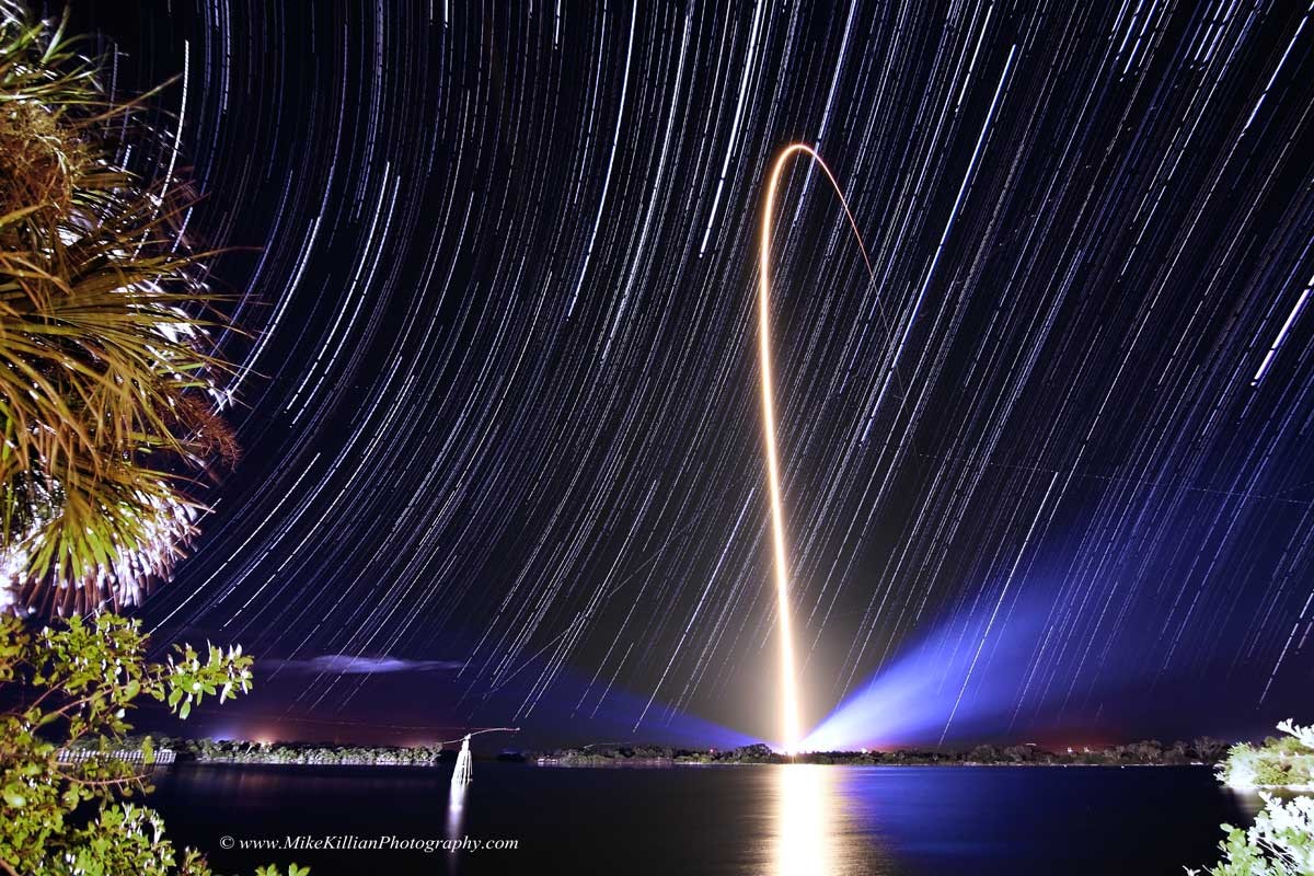
Rocket Streak and Star Trails
* Image Credit & Copyright: Mike Killian / AmericaSpace
Explanation:
Fixed to a tripod and looking east across the Kennedy Space Center's Turn Basin, a camera captured these star trails as a series of short exposures over a three hour period on the evening of January 23rd. Positioned just a few miles from Space Launch Complex 41 at Cape Canaveral Air Force Station, it also captured a spectacular night launch of an Atlas V rocket carrying NASA's Tracking and Data Relay Satellite TDRS-L. Creating the trails, the apparent motion of the stars through the sky is just a reflection of the daily rotation of planet Earth on its axis. But that rotation is also the reason the rocket streak follows a path arcing east across the Atlantic. Launching toward the east, in the direction of Earth's rotation, adds the rotation velocity to the rocket and reduces the fuel needed to reach orbit. A little ironically, TDRS-L is destined for a geostationary orbit. From there, 36,000 kilometers or so above the equator, its orbital period will match Earth's rotation and the satellite will hang motionless in planet Earth's sky.
https://apod.nasa.gov/apod/ap140130.html
#space #earth #astrophotography #photography #astroart #science #nature
Alt...
2014 January 30
Rocket Streak and Star Trails
* Image Credit & Copyright: Mike Killian / AmericaSpace
Explanation:
Fixed to a tripod and looking east across the Kennedy Space Center's Turn Basin, a camera captured these star trails as a series of short exposures over a three hour period on the evening of January 23rd. Positioned just a few miles from Space Launch Complex 41 at Cape Canaveral Air Force Station, it also captured a spectacular night launch of an Atlas V rocket carrying NASA's Tracking and Data Relay Satellite TDRS-L. Creating the trails, the apparent motion of the stars through the sky is just a reflection of the daily rotation of planet Earth on its axis. But that rotation is also the reason the rocket streak follows a path arcing east across the Atlantic. Launching toward the east, in the direction of Earth's rotation, adds the rotation velocity to the rocket and reduces the fuel needed to reach orbit. A little ironically, TDRS-L is destined for a geostationary orbit. From there, 36,000 kilometers or so above the equator, its orbital period will match Earth's rotation and the satellite will hang motionless in planet Earth's sky.
Authors & editors: Robert Nemiroff (MTU) & Jerry Bonnell (UMCP)
NASA Official: Phillip Newman Specific rights apply.
NASA Web Privacy Policy and Important Notices
A service of: ASD at NASA / GSFC
& Michigan Tech. U.
Grand Canyon Star Trails
* Image Credit & Copyright: Babak Tafreshi (TWAN)
Explanation:
One of the natural wonders of planet Earth, the Grand Canyon in the American southwest stretches across this early evening skyscape. The digitally stacked sequence reveals the canyon's layers of sedimentary rock in bright moonlight. Exposed sedimentary rock layers range in age from about 200 million to 2 billion years old, a window to history on a geological timescale. A recent study has found evidence that the canyon itself may have been carved by erosion as much as 70 million years ago. With the camera fixed to a tripod while Earth rotates, each star above carves a graceful arc through the night sky. The concentric arcs are centered on the north celestial pole, the extension of Earth's rotation axis into space, presently near the bright star Polaris.
https://apod.nasa.gov/apod/ap130303.html
#space #earth #astrophotography #photography #astroart #art #science #nature
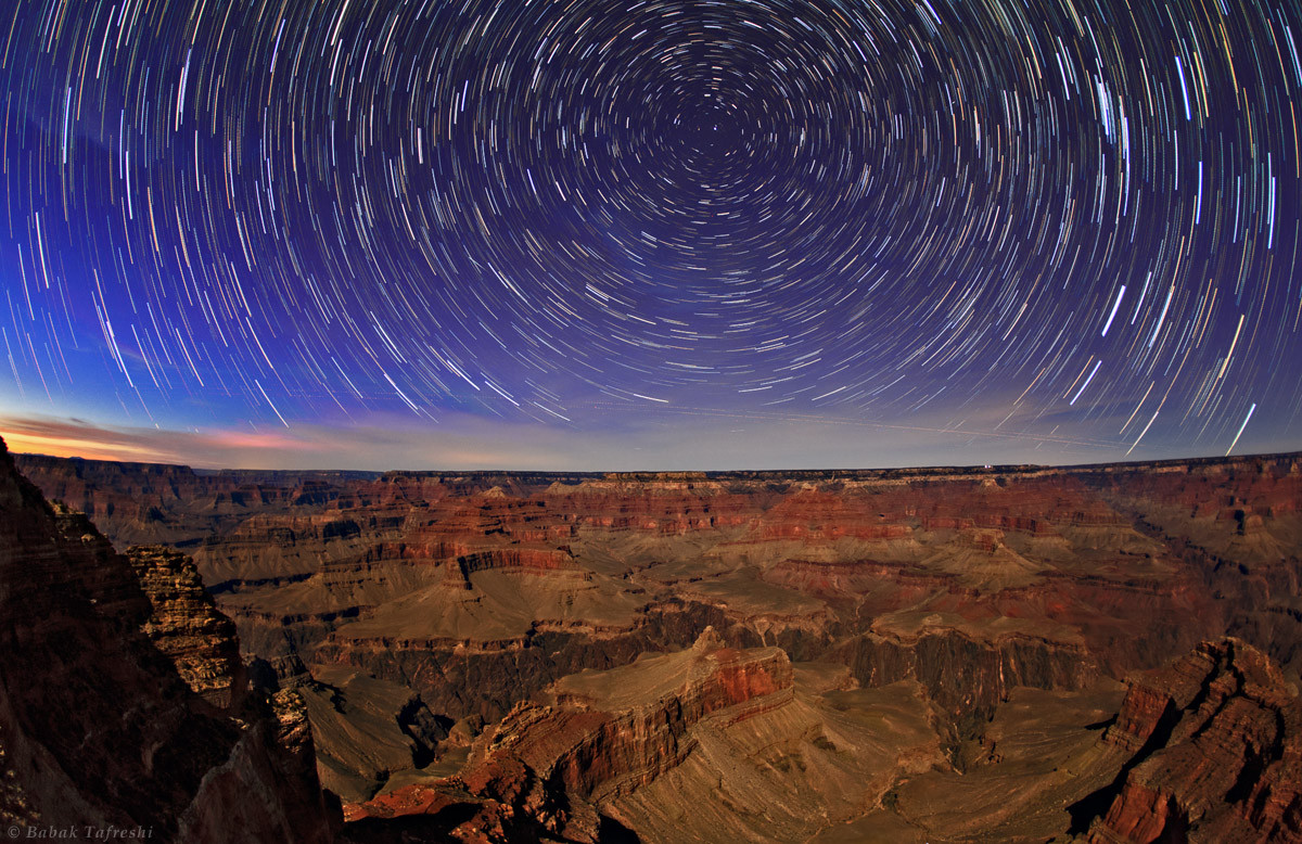
Alt...
2013 March 3
Grand Canyon Star Trails
* Image Credit & Copyright: Babak Tafreshi (TWAN)
Explanation:
One of the natural wonders of planet Earth, the Grand Canyon in the American southwest stretches across this early evening skyscape. The digitally stacked sequence reveals the canyon's layers of sedimentary rock in bright moonlight. Exposed sedimentary rock layers range in age from about 200 million to 2 billion years old, a window to history on a geological timescale. A recent study has found evidence that the canyon itself may have been carved by erosion as much as 70 million years ago. With the camera fixed to a tripod while Earth rotates, each star above carves a graceful arc through the night sky. The concentric arcs are centered on the north celestial pole, the extension of Earth's rotation axis into space, presently near the bright star Polaris.
Authors & editors: Robert Nemiroff (MTU) & Jerry Bonnell (UMCP)
NASA Official: Phillip Newman Specific rights apply.
NASA Web Privacy Policy and Important Notices
A service of: ASD at NASA / GSFC
& Michigan Tech. U.
Teimareh Petroglyphs and Star Trails
* Image Credit & Copyright: Babak Tafreshi (TWAN)
Explanation:
Engraved in rock, these ancient petroglyphs are abundant in the Teimareh valley, located in the Zagros Mountains of central Iran. They likely tell a tale of hunters and animals found in the middle eastern valley 6,000 years ago or more, etched by artists in a prehistoric age. In the night sky above are star trails etched by the rotation of planet Earth during the long composite exposure made with a modern digital camera. On the left, the center of the star trail arcs is the North Celestial Pole (NCP), the extension of Earth's axis into space. Polaris, the North Star, leaves the bright, short, stubby trail closest to the NCP. But when these petroglyphs were carved, Polaris would have made a long arc through the night. Since the Earth's rotation axis precesses like a wobbling top, 6,000 years ago the NCP was near the border of the constellations Draco and Ursa Major, some 30 degrees from its current location in planet Earth's sky.
https://apod.nasa.gov/apod/ap120712.html
#space #earth #astrophotography #photography #astroart #art #science #nature
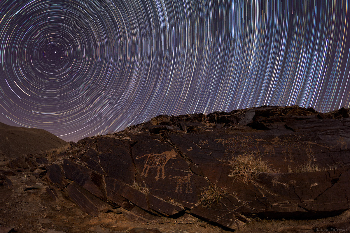
Alt...
2012 July 12
Teimareh Petroglyphs and Star Trails
* Image Credit & Copyright: Babak Tafreshi (TWAN)
Explanation:
Engraved in rock, these ancient petroglyphs are abundant in the Teimareh valley, located in the Zagros Mountains of central Iran. They likely tell a tale of hunters and animals found in the middle eastern valley 6,000 years ago or more, etched by artists in a prehistoric age. In the night sky above are star trails etched by the rotation of planet Earth during the long composite exposure made with a modern digital camera. On the left, the center of the star trail arcs is the North Celestial Pole (NCP), the extension of Earth's axis into space. Polaris, the North Star, leaves the bright, short, stubby trail closest to the NCP. But when these petroglyphs were carved, Polaris would have made a long arc through the night. Since the Earth's rotation axis precesses like a wobbling top, 6,000 years ago the NCP was near the border of the constellations Draco and Ursa Major, some 30 degrees from its current location in planet Earth's sky.
Authors & editors: Robert Nemiroff (MTU) & Jerry Bonnell (UMCP)
NASA Official: Phillip Newman Specific rights apply.
NASA Web Privacy Policy and Important Notices
A service of: ASD at NASA / GSFC
& Michigan Tech. U.
La Silla Star Trails North and South
* Image Credit & Copyright: Alexandre Santerne (Laboratoire d'Astrophysique de Marseille / Observatoire de Haute Provence)
Explanation:
If the tripod is set up at ESO's La Silla Observatory, high in the Atacama desert of Chile, your star trails would look something like this. Spanning about 4 hours on the night of January 24, the image is actually a composite of 250 consecutive 1-minute exposures, looking toward the north. The North Celestial Pole, at the center of the star trail arcs, is just below the horizon in this southern hemisphere perspective. In the foreground, the polished 15-meter diameter dish antenna of the Swedish-ESO Submillimeter Telescope (now decommissioned) shows star trails toward the south by reflection. Sweeping around the South Celestial Pole, the distorted arcs of those stars appear underneath the southern horizon in the focusing dish's inverted view. Right of the dish is the dome of the observatory's 3.6 meter telescope, home to the planet hunting HARPS spectrograph.
https://apod.nasa.gov/apod/ap120202.html
#space #earth #astrophotography #photography #astroart #art #science #nature
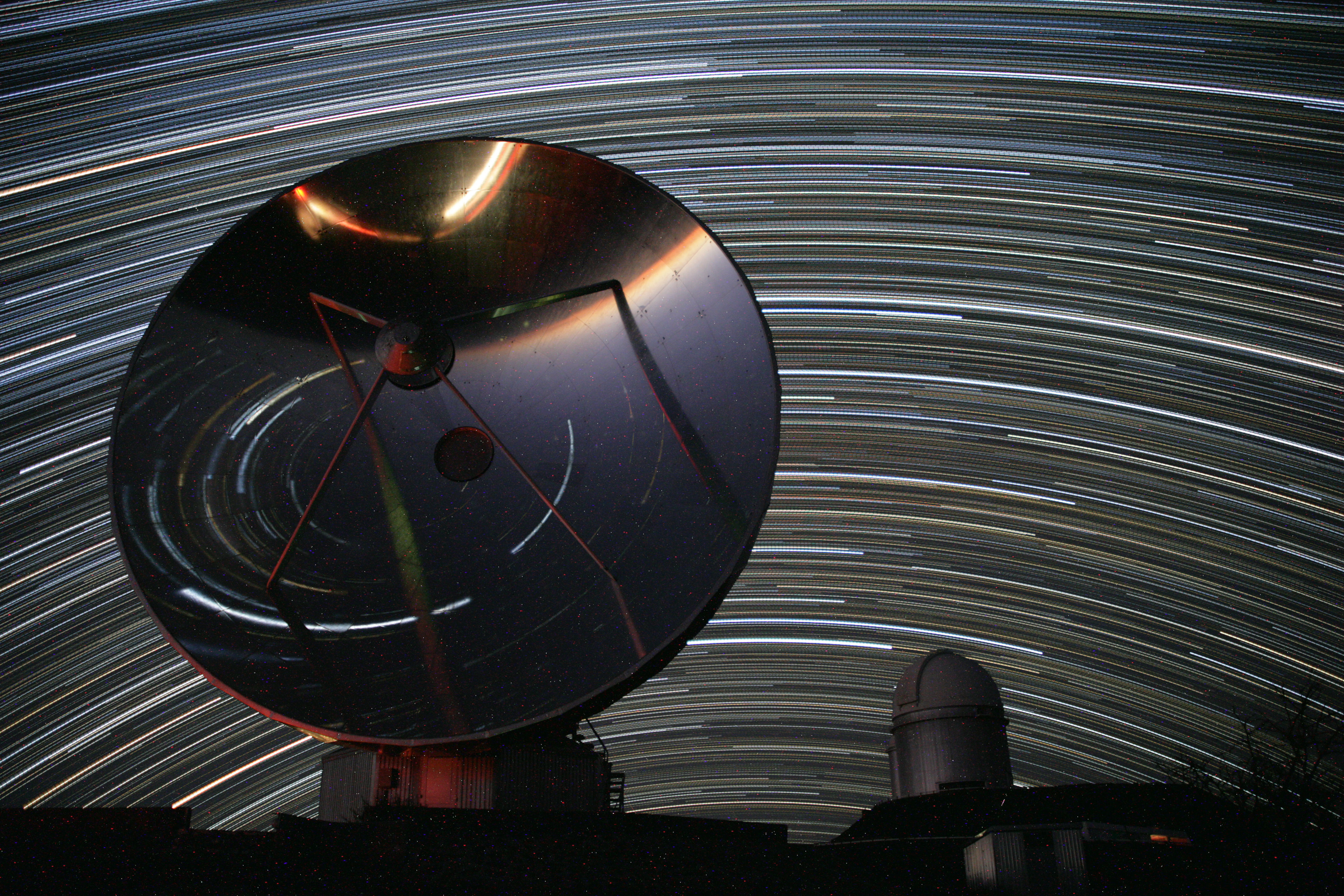
Alt...
2012 February 2
La Silla Star Trails North and South
* Image Credit & Copyright: Alexandre Santerne (Laboratoire d'Astrophysique de Marseille / Observatoire de Haute Provence)
Explanation:
If the tripod is set up at ESO's La Silla Observatory, high in the Atacama desert of Chile, your star trails would look something like this. Spanning about 4 hours on the night of January 24, the image is actually a composite of 250 consecutive 1-minute exposures, looking toward the north. The North Celestial Pole, at the center of the star trail arcs, is just below the horizon in this southern hemisphere perspective. In the foreground, the polished 15-meter diameter dish antenna of the Swedish-ESO Submillimeter Telescope (now decommissioned) shows star trails toward the south by reflection. Sweeping around the South Celestial Pole, the distorted arcs of those stars appear underneath the southern horizon in the focusing dish's inverted view. Right of the dish is the dome of the observatory's 3.6 meter telescope, home to the planet hunting HARPS spectrograph.
Authors & editors: Robert Nemiroff (MTU) & Jerry Bonnell (UMCP)
NASA Official: Phillip Newman Specific rights apply.
NASA Web Privacy Policy and Important Notices
A service of: ASD at NASA / GSFC
& Michigan Tech. U.
MAGIC Star Trails
* Image Credit & Copyright: Babak Tafreshi (TWAN)
Explanation:
Colorful star trails arc across the night in this surreal timelapse skyscape from the Roque de los Muchachos Observatory on the Canary island of La Palma. A reflection of the Earth's daily rotation on its axis, the star trails are also reflected in one of a pair of 17 meter diameter, multi-mirrored MAGIC telescopes. The MAGIC (Major Atmospheric Gamma Imaging Cherenkov) telescope itself is intended to detect gamma rays - photons with over 100 billion times the energy of visible light. As the high energy gamma rays impact the upper atmosphere they produce air showers of high-energy particles. A fast camera monitoring the multi-mirrored surface records in detail brief flashes of optical light, called Cherenkov light, created by the air shower particles. Astronomers can then ultimately relate the optical flashes to cosmic sources of extreme gamma-rays.
https://apod.nasa.gov/apod/ap111014.html
#space #earth #astrophotography #photography #astroart #science #nature
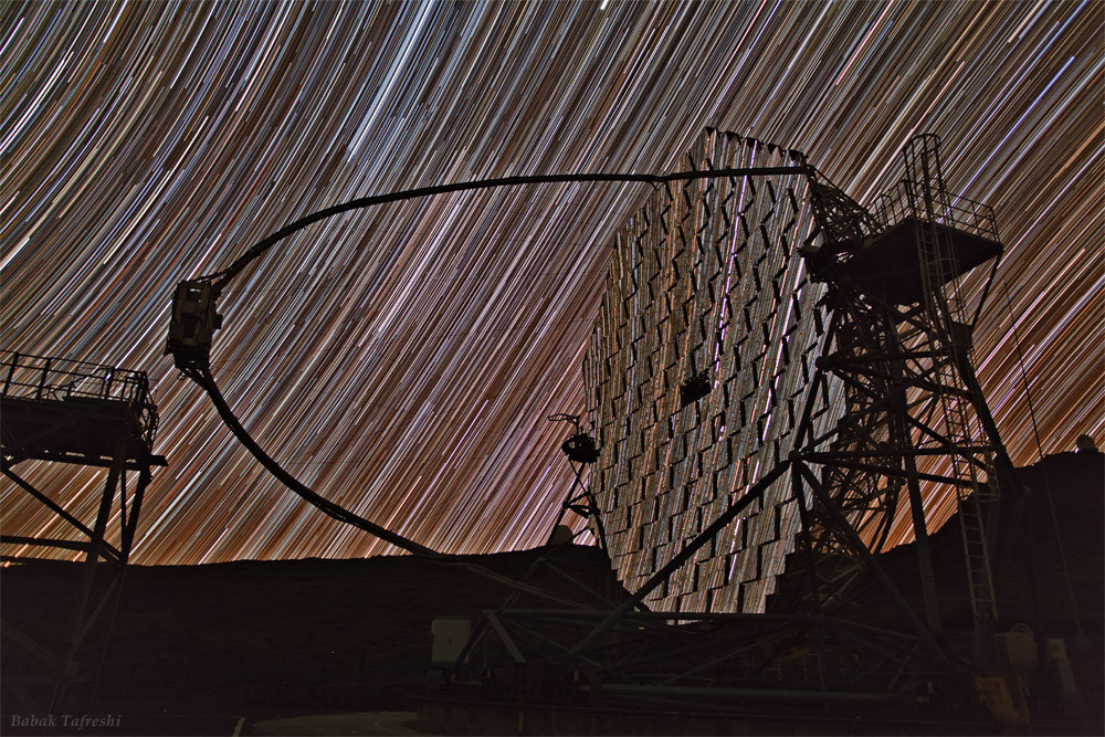
Alt...
2011 October 14
MAGIC Star Trails
* Image Credit & Copyright: Babak Tafreshi (TWAN)
Explanation:
Colorful star trails arc across the night in this surreal timelapse skyscape from the Roque de los Muchachos Observatory on the Canary island of La Palma. A reflection of the Earth's daily rotation on its axis, the star trails are also reflected in one of a pair of 17 meter diameter, multi-mirrored MAGIC telescopes. The MAGIC (Major Atmospheric Gamma Imaging Cherenkov) telescope itself is intended to detect gamma rays - photons with over 100 billion times the energy of visible light. As the high energy gamma rays impact the upper atmosphere they produce air showers of high-energy particles. A fast camera monitoring the multi-mirrored surface records in detail brief flashes of optical light, called Cherenkov light, created by the air shower particles. Astronomers can then ultimately relate the optical flashes to cosmic sources of extreme gamma-rays.
Authors & editors: Robert Nemiroff (MTU) & Jerry Bonnell (UMCP)
NASA Official: Phillip Newman Specific rights apply.
NASA Web Privacy Policy and Important Notices
A service of: ASD at NASA / GSFC
& Michigan Tech. U.
A Summer Night's Dream
* Image Credit & Copyright: Mike Rosinski
Explanation:
Fix your digital camera to a tripod, start a long series of exposures, and you too can record star trails. The concentric arcs traced by the stars as planet Earth rotates on its axis often produce dreamlike scenes in otherwise familiar situations. Fall asleep, though, and the results might surprise you. Setting up on a summer night, photographer Mike Rosinski began his exposures, initially planning to capture about 45-55 minutes worth of star trails from his yard in Hartland, Michigan, USA. But he dozed, only to awaken some 3 hours later to find his camera had continued to run until the battery died. Composing the resulting images, the graceful concentric star trails were expected, along with light from a late rising Moon glinting on windows. Still, as he slept on the warm night a blizzard of yellow streaks flooded the scene, not left by fairies but fireflies.
https://apod.nasa.gov/apod/ap110805.html
#space #earth #astrophotography #photography #astroart #science #nature
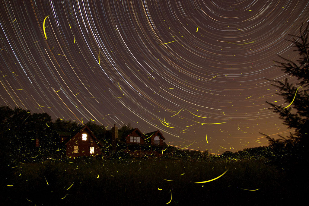
Alt...
2011 August 5
A Summer Night's Dream
* Image Credit & Copyright: Mike Rosinski
Explanation:
Fix your digital camera to a tripod, start a long series of exposures, and you too can record star trails. The concentric arcs traced by the stars as planet Earth rotates on its axis often produce dreamlike scenes in otherwise familiar situations. Fall asleep, though, and the results might surprise you. Setting up on a summer night, photographer Mike Rosinski began his exposures, initially planning to capture about 45-55 minutes worth of star trails from his yard in Hartland, Michigan, USA. But he dozed, only to awaken some 3 hours later to find his camera had continued to run until the battery died. Composing the resulting images, the graceful concentric star trails were expected, along with light from a late rising Moon glinting on windows. Still, as he slept on the warm night a blizzard of yellow streaks flooded the scene, not left by fairies but fireflies.
Authors & editors: Robert Nemiroff (MTU) & Jerry Bonnell (UMCP)
NASA Official: Phillip Newman Specific rights apply.
NASA Web Privacy Policy and Important Notices
A service of: ASD at NASA / GSFC
& Michigan Tech. U.
Lewin's Challenge: 360 Degree Star Trails
* Image Credit & Copyright: Peter Wienerroither (U. Wien)
Explanation:
You could be the first person ever to take a real single-exposure image like this. The above image from Vienna, Austria is not real in the sense that the 360 degree star trails in the sky appear only because of a digital trick. Real star trails observed above Vienna could never go 360 degrees around because the Sun would rise at some time during the exposure and dominate the frame. Star trails of any length occur because as the Earth spins on its axis, the sky seems to rotate around us. This motion, called diurnal motion, produces the beautiful concentric arcs traced by stars during long time exposures. Towards the middle of the above digitally stretched picture is the North Celestial Pole (NCP), easily identified as the point in the sky at the center of all the star trail arcs. The star Polaris, commonly known as the North Star, made the very short bright circle near the NCP. Walter Lewin, though, has asked APOD to pose this as a challenge to astrophotographers: create a real single-exposure image of a clear night sky that features 360 degree star trails. Of course, such an image would only be possible near the poles of our fair planet, because only there could a nighttime run for more than 24 hours.
https://apod.nasa.gov/apod/ap110717.html
#space #earth #astrophotography #photography #astroart #science #nature
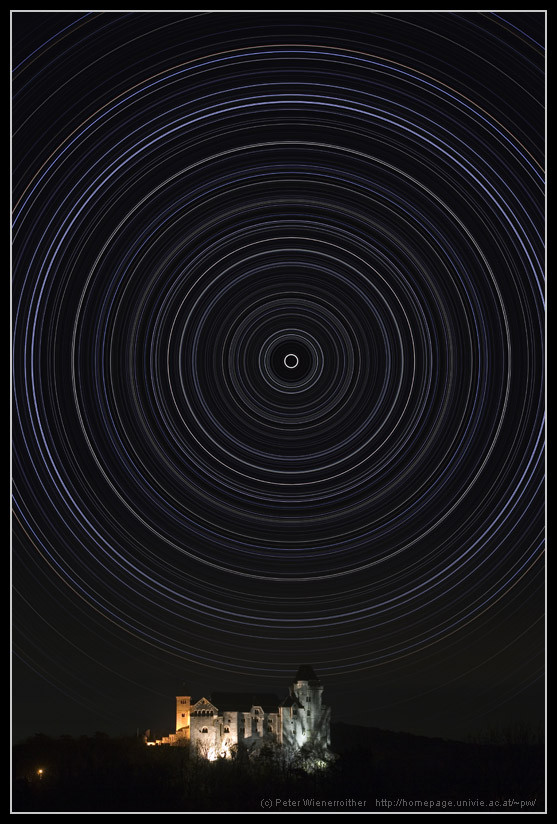
Alt...
2011 July 17
Lewin's Challenge: 360 Degree Star Trails
* Image Credit & Copyright: Peter Wienerroither (U. Wien)
Explanation:
You could be the first person ever to take a real single-exposure image like this. The above image from Vienna, Austria is not real in the sense that the 360 degree star trails in the sky appear only because of a digital trick. Real star trails observed above Vienna could never go 360 degrees around because the Sun would rise at some time during the exposure and dominate the frame. Star trails of any length occur because as the Earth spins on its axis, the sky seems to rotate around us. This motion, called diurnal motion, produces the beautiful concentric arcs traced by stars during long time exposures. Towards the middle of the above digitally stretched picture is the North Celestial Pole (NCP), easily identified as the point in the sky at the center of all the star trail arcs. The star Polaris, commonly known as the North Star, made the very short bright circle near the NCP. Walter Lewin, though, has asked APOD to pose this as a challenge to astrophotographers: create a real single-exposure image of a clear night sky that features 360 degree star trails. Of course, such an image would only be possible near the poles of our fair planet, because only there could a nighttime run for more than 24 hours.
Authors & editors: Robert Nemiroff (MTU) & Jerry Bonnell (UMCP)
NASA Official: Phillip Newman Specific rights apply.
Scintillating
* Image Credit & Copyright: Juergen Michelberger
Explanation:
On June 4, 2010 Regulus, alpha star of the constellation Leo, and wandering planet Mars were at about the same apparent brightness, separated on the sky by 1.5 degrees. An ingenious and creative 10 second exposure from a swinging camera recorded these gyrating trails of the celestial pairing. Can you tell which trail belongs to the star and which to the planet? Hint: atmospheric turbulence causes the image of the star to scintillate or vary in brightness and color more readily than the planet. The scintillation is more pronounced because the star is effectively a point source of light seen as a narrow bundle of light rays. Rapidly changing refraction due to turbulence along the line of sight affects different colors of light by different amounts and generally produces a twinkling effect for stars. But Mars is much closer than the distant stars and an extended source of light. Though tiny, its disk is seen as a bundle of light rays that is substantially broader compared to a star's and so, on average, less affected by small scale turbulence. The result is the varied, rainbow like trail for Regulus (left) and the steadier, consistently reddish trail for Mars.
https://apod.nasa.gov/apod/ap110428.html
#space #earth #astrophotography #photography #astroart #science #nature
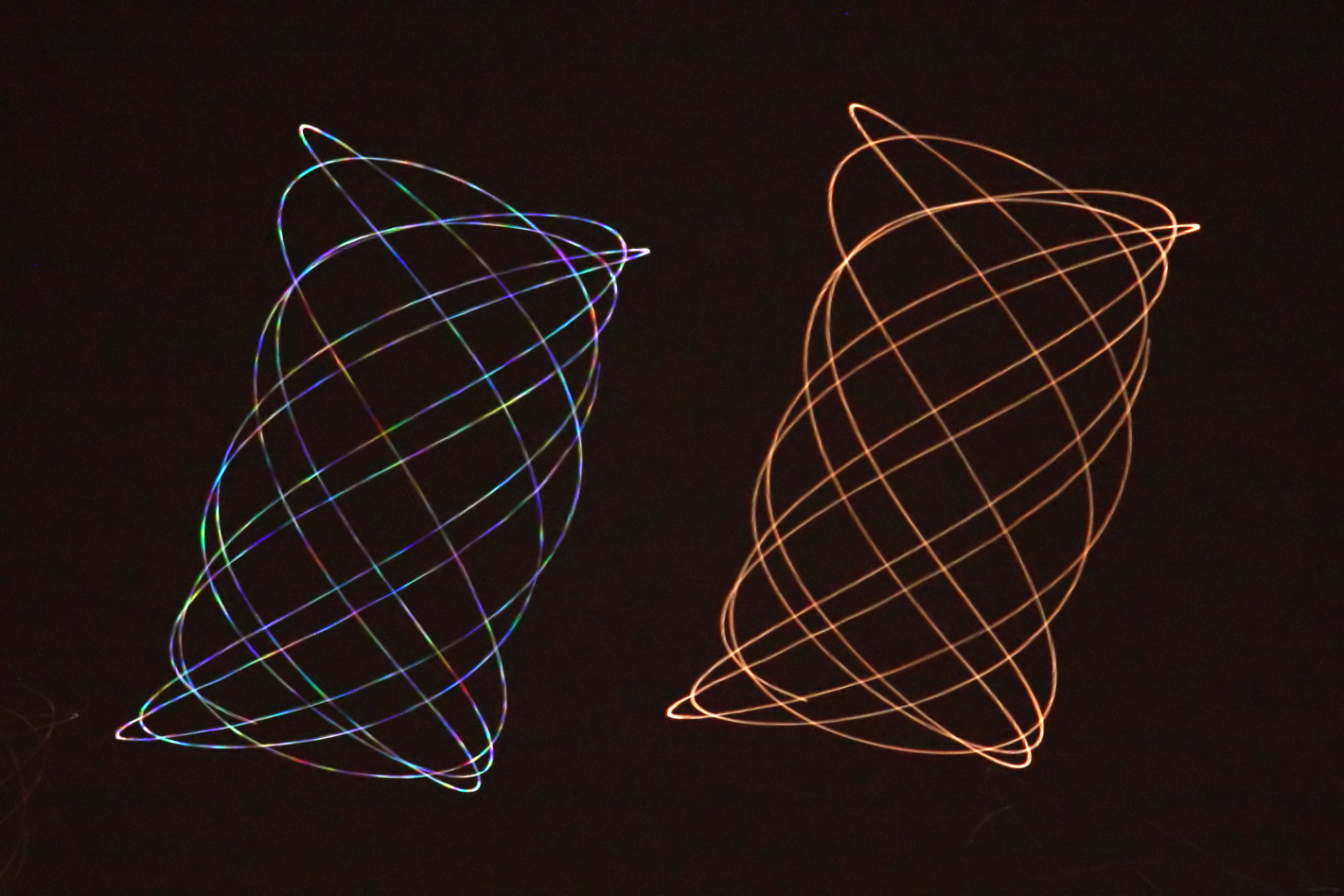
Alt...
2011 April 28
Scintillating
* Image Credit & Copyright: Juergen Michelberger
Explanation:
On June 4, 2010 Regulus, alpha star of the constellation Leo, and wandering planet Mars were at about the same apparent brightness, separated on the sky by 1.5 degrees. An ingenious and creative 10 second exposure from a swinging camera recorded these gyrating trails of the celestial pairing. Can you tell which trail belongs to the star and which to the planet? Hint: atmospheric turbulence causes the image of the star to scintillate or vary in brightness and color more readily than the planet. The scintillation is more pronounced because the star is effectively a point source of light seen as a narrow bundle of light rays. Rapidly changing refraction due to turbulence along the line of sight affects different colors of light by different amounts and generally produces a twinkling effect for stars. But Mars is much closer than the distant stars and an extended source of light. Though tiny, its disk is seen as a bundle of light rays that is substantially broader compared to a star's and so, on average, less affected by small scale turbulence. The result is the varied, rainbow like trail for Regulus (left) and the steadier, consistently reddish trail for Mars.
Authors & editors: Robert Nemiroff (MTU) & Jerry Bonnell (UMCP)
NASA Official: Phillip Newman Specific rights apply.
NASA Web Privacy Policy and Important Notices
A service of: ASD at NASA / GSFC
& Michigan Tech. U.
Night and Day above Almost Planet Sounio
* Credit & Copyright: Chris Kotsiopoulos (GreekSky)
Explanation:
Has a new planet been discovered? What is pictured above is a remarkable 24 hour mosaic surrounding a spot on Sounio, Greece, right here on planet Earth. Images taken at night compose the top half of the picture, with star trails lasting as long as 11 hours visible. Contrastingly, images taken during the day compose the bottom of the image, with the Sun being captured once every 15 minutes. The image center shows a Little Prince wide angle projection centered on the ground but including gravel, grass, trees, Saint John's church, clouds, crepuscular rays, and even a signature icon of the photographer -- the Temple of Poseidon. Meticulous planning as well as several transition shots and expert digital processing eventually culminated in this image documenting half of the final two days of last year.
https://apod.nasa.gov/apod/ap110117.html
#space #earth #astrophotography #photography #astroart #art #science #nature
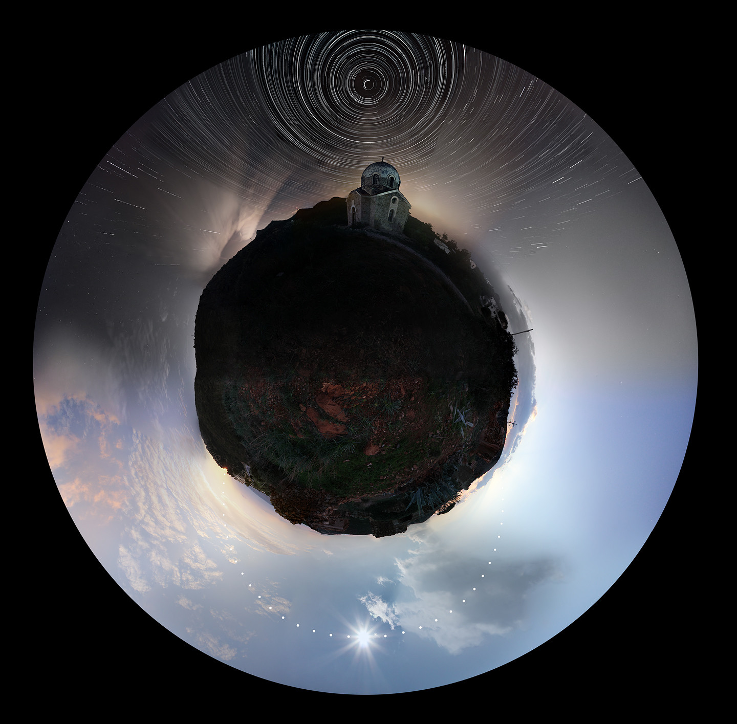
Alt...
2011 January 17
Night and Day above Almost Planet Sounio
* Credit & Copyright: Chris Kotsiopoulos (GreekSky)
Explanation:
Has a new planet been discovered? What is pictured above is a remarkable 24 hour mosaic surrounding a spot on Sounio, Greece, right here on planet Earth. Images taken at night compose the top half of the picture, with star trails lasting as long as 11 hours visible. Contrastingly, images taken during the day compose the bottom of the image, with the Sun being captured once every 15 minutes. The image center shows a Little Prince wide angle projection centered on the ground but including gravel, grass, trees, Saint John's church, clouds, crepuscular rays, and even a signature icon of the photographer -- the Temple of Poseidon. Meticulous planning as well as several transition shots and expert digital processing eventually culminated in this image documenting half of the final two days of last year.
Authors & editors: Robert Nemiroff (MTU) & Jerry Bonnell (UMCP)
NASA Official: Phillip Newman Specific rights apply.
NASA Web Privacy Policy and Important Notices
A service of: ASD at NASA / GSFC
& Michigan Tech. U.
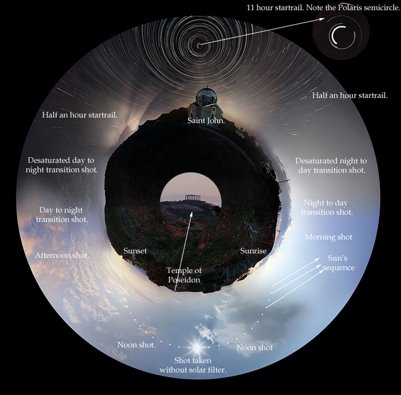
Alt...
2011 January 17
Night and Day above Almost Planet Sounio
* Credit & Copyright: Chris Kotsiopoulos (GreekSky)
Explanation:
Has a new planet been discovered? What is pictured above is a remarkable 24 hour mosaic surrounding a spot on Sounio, Greece, right here on planet Earth. Images taken at night compose the top half of the picture, with star trails lasting as long as 11 hours visible. Contrastingly, images taken during the day compose the bottom of the image, with the Sun being captured once every 15 minutes. The image center shows a Little Prince wide angle projection centered on the ground but including gravel, grass, trees, Saint John's church, clouds, crepuscular rays, and even a signature icon of the photographer -- the Temple of Poseidon. Meticulous planning as well as several transition shots and expert digital processing eventually culminated in this image documenting half of the final two days of last year.
Authors & editors: Robert Nemiroff (MTU) & Jerry Bonnell (UMCP)
NASA Official: Phillip Newman Specific rights apply.
NASA Web Privacy Policy and Important Notices
A service of: ASD at NASA / GSFC
& Michigan Tech. U.
Quadrantids over Qumis
* Image Credit & Copyright: Babak Tafreshi (TWAN)
Explanation:
The Quadrantid Meteor Shower is an annual event for planet Earth's northern hemisphere skygazers. It usually peaks briefly in the cold, early morning hours of January 4. The shower is named for its radiant point on the sky within the old, astronomically obsolete constellation Quadrans Muralis. That position is situated near the boundaries of the modern constellations Hercules, Bootes, and Draco. In this haunting time exposure, two quadrantid meteor streaks are captured crossing trails left by rising stars of the constellations Virgo and Corvus, but Saturn leaves the brightest "star" trail. The meteor streaks, one bright and one faint, are nearly parallel above and right of center in the frame. Fittingly, the old cistern structure in the foreground lies above the now buried city of Qumis. Known as a city of many gates, Qumis (in Greek history Hecatompylos), was founded 2300 years ago in ancient Persia.
https://apod.nasa.gov/apod/ap110114.html
#space #earth #astrophotography #photography #science #nature
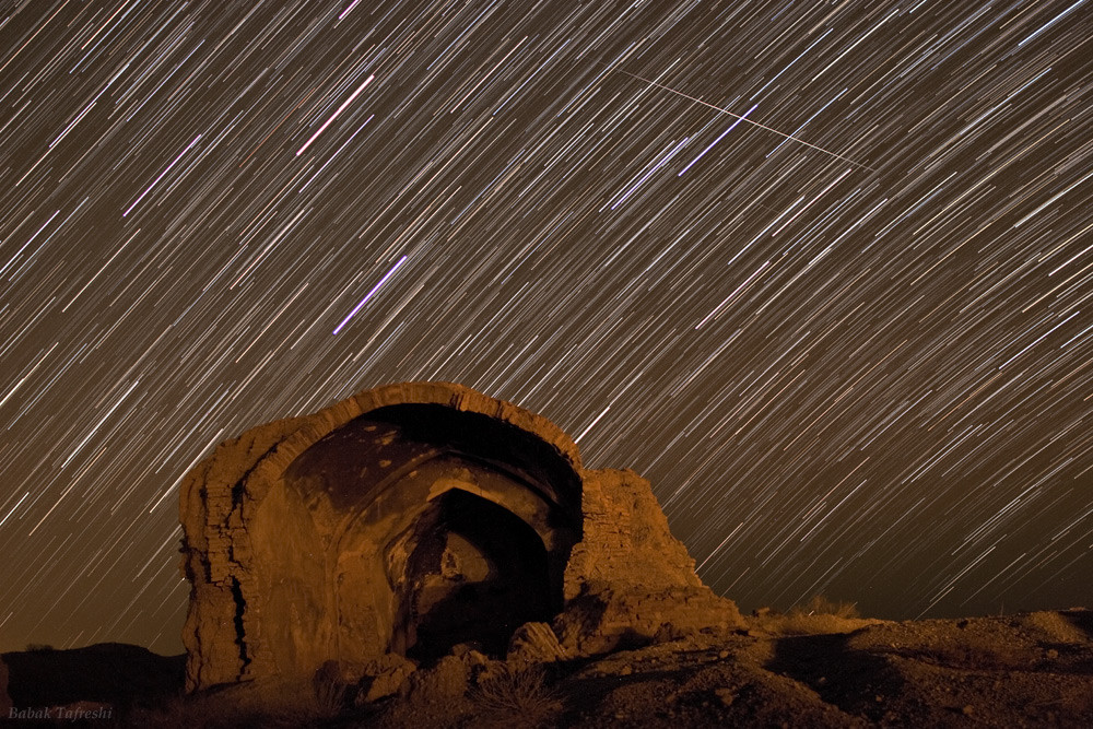
Alt...
2011 January 14
Quadrantids over Qumis
* Image Credit & Copyright: Babak Tafreshi (TWAN)
Explanation:
The Quadrantid Meteor Shower is an annual event for planet Earth's northern hemisphere skygazers. It usually peaks briefly in the cold, early morning hours of January 4. The shower is named for its radiant point on the sky within the old, astronomically obsolete constellation Quadrans Muralis. That position is situated near the boundaries of the modern constellations Hercules, Bootes, and Draco. In this haunting time exposure, two quadrantid meteor streaks are captured crossing trails left by rising stars of the constellations Virgo and Corvus, but Saturn leaves the brightest "star" trail. The meteor streaks, one bright and one faint, are nearly parallel above and right of center in the frame. Fittingly, the old cistern structure in the foreground lies above the now buried city of Qumis. Known as a city of many gates, Qumis (in Greek history Hecatompylos), was founded 2300 years ago in ancient Persia.
Authors & editors: Robert Nemiroff (MTU) & Jerry Bonnell (UMCP)
NASA Official: Phillip Newman Specific rights apply.
NASA Web Privacy Policy and Important Notices
A service of: ASD at NASA / GSFC
& Michigan Tech. U.